Typhoon Tip
-
Posts
40,583 -
Joined
-
Last visited
Content Type
Profiles
Blogs
Forums
American Weather
Media Demo
Store
Gallery
Everything posted by Typhoon Tip
-
We may not need waiting until after mid month ... In fact, I'd almost suggest that more likely players are troika through the 14th, then it may go cold and quiescent there after for awhile, because I agree with the compression - it's more than a mere observation; it's a large scale negative interference product that will limit the intra-scale events from ever being able to amplify. That said, the three system - their success notwithstanding in this statement ... - that occur ~ the 6th, 9 or 10th, and the 13th-ish, are occurring prior to any such enhanced compression and therefore for more identity conserved - which leads to actual events succeeding in taking place.
-
I slept in this morning so bite it - that 06z GFS for the 9/10th was a mise-en-science of winter joy... It reminded me of that event in 2015, the one that came thru as more of a protracted WAA, with a series of waves along it, with arctic air entrenched on the N side. Something like 15" occurred here from that, and I don't thing surface pressure of any of those two waves on the front back then were less than 1000mb by very much. But is snowed moderate with some blowing and drifting for 18 hours straight - I'm about going half from memory here, half from artistry because I remember it happened more so than the details. Anyway, this 06z is about the only way to get a longer duration event out of compressed, velocity saturated flow type. It's also interesting that the 18, 00z runs leading were not hugely different. Last I checked, the op Euro was in another universe - Haven't seen any other guidance.
-
Unlikely its speed is guided by the character of the pattern foot … Im sure you’ve heard us speak of “compression”? That’s synonymous with fast bigger event on the 9th but seems suspiciously too amped given those same constraints
-
The models haven’t been completely giving up on the 6th and now the GFS 00z with a quick moving moderate event. This is < 6 days out there too
-
North of the Pike Slop Fest Jan 31-Feb 1
Typhoon Tip replied to HoarfrostHubb's topic in New England
Roads went white as soon as it switched here about a half hr ago 32 S -
North of the Pike Slop Fest Jan 31-Feb 1
Typhoon Tip replied to HoarfrostHubb's topic in New England
Yeah been watching that for the last couple hours as it's unzipped east from southern ny/n pa... I'm wondering what that looks like when it moves over the 35 air along rt 2 -
Perfectly stated!
-
For now hold... but geesh! not impossible that we're seeing the local hemisphere through winter goggles. I'm guilty of it too. I mean I mentioned heat burst and recent seasons and -PNA and all that.. but, hammering consistency by these materialized charts gets a bit overbearing. Models are going to struggle with that boundary - that's a slam dunk for poor performance. Unfortunately ...about top shelf premium error magnitude exists across where ever that is
-
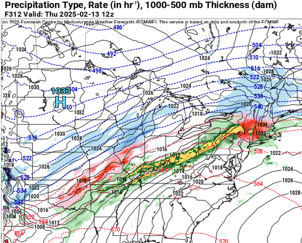
It's really not that much different than the going ideas, it's just about 200 mi or so further N with the front. The problem is, there's like 50 to 60 degrees of variance across the fugger ... That 312 hour frame could be nearing 75 in S Jersey, while Kevin blacks out and we don't get to see his posts anywhere ( oh no! ) from icing - This gradient thing is getting rather excessive, all necessary jokes aside - I mean, you wonder if this is even possible..
-
hahaha ... I'm like
-
Ha ha omg ... dudes, we're not getting and ice "storm" in this kind of hyper velocity cosmic ray jet out of a quasar flow type. A 300 mile long icing strip gets through in 6 hours. Light to moderate fall rates blasting through so quickly would lower the semantic requirement to something beneath storm. LOL
-
I suppose it doesn't matter how exactly and/or what precedes the splitting of the PV into SPV layout ... If it splits, it splits. The key is whether it involves/couples to the troposphere - the mechanism in which that happens is through stabilizing the UVM toward DVM, and that then physically drafts warm air from surrounding the PV domain into the elevated domain --> warm nodes at high altitudes and blocking results... That's the very skinny on how that works. The thermal field projections off the GFS are not clear as to whether there is an actual thermal plume in the process of moving down in the column. There are warm layers, however - which could be the same thing just difficult to distinguish in the coarseness of the sigmas offered. Unless someone has a different more liquid source: https://www.cpc.ncep.noaa.gov/products/stratosphere/strat_a_f/ In any case, a split that couples would highly likely register as a -AO ... I would suggest if that happens sooner rather than 3 weeks from now, that it is not an SSW but just a planetary reshuffling leading to a similar result. A -AO from either source bears no difference to middle latitudes after the fact. It's a cold index mode and it comes down to where the hemispheric conveyors decide to layout for determining the mid latitude temperature distribution.
-
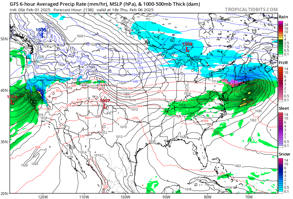
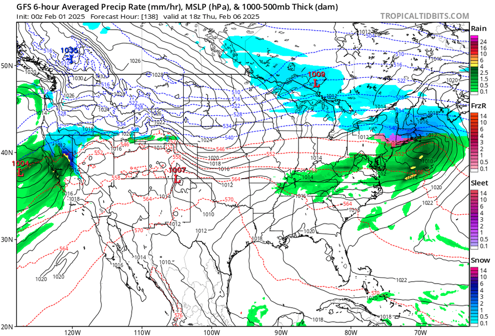
The 6th and the 9th look almost identical in the general 500 mb cinema of the 12z GFS run... Not sure how that will manifest and/or be different at the surface, but just looking at that one metric -
-
technically still a needle thread pattern foot.
-
Yup these high alt warm nodes are not uncommon. Most are not initiators … though the few that are, may ‘pulse’ in an out of the verification before the big burst occurs. I checked all this yesterday and though there is an impressive warm node modeled d8 or so in the 10s … at least in so far as the GFS, there wasn’t much of a subsequent penetration down to 30 .. 50. It may have changed in that guidance since yesterday re these lower sigma levels but I haven’t checked today. Even if so … folks, you’re looking at 20 days min before the AO response. If the index is neggie prior to that … it’s likely motivated from other physical influences, because the down welling propagation takes time to arrive thru the tropopause region to where it couples.
-
North of the Pike Slop Fest Jan 31-Feb 1
Typhoon Tip replied to HoarfrostHubb's topic in New England
okay, so .. having looked at that NAM my self. The model paints rain, intensity not withstanding ..., through early evening than a change to snow along Rt 2 in N. Ma between 5 and 7 pm. It may snow moderately at times, but most likely light thereafter through 1am. Then the whole system mercifully dwindles off into the Atlantic where we can finally never have to talk its irrelevancy again ... Not sure what individual expectations are with this thing but the current behavior appears to match the 12z run from what I'm seeing. -
North of the Pike Slop Fest Jan 31-Feb 1
Typhoon Tip replied to HoarfrostHubb's topic in New England
Like I said ... always a risk with the NAM lol -
North of the Pike Slop Fest Jan 31-Feb 1
Typhoon Tip replied to HoarfrostHubb's topic in New England
Perhaps ... it is the NAM. Never a bad idea LOL That said, it is 36/31 here, however ... I personally fail to see where we are getting warm air into this region above the deck. The sounding is chilly, suggesting any warmth at all is restricted to the surface to 1200' Every sigma above is at or below 0C? 'less I'm mistaken. Probably fall rates dictate this bad boys distribution - -
It's aggression ... You're talking about the motivation behind it. The act of doing so, without confer and diplomacy and all the other tacts of "civility" that demonstrate respect for sovereignty, is absolutely an abysmal act of fuckin aggression.
-
Right, so based on that logic, Mexico should be changed to America - why stop at the Gulf. It's not based on geodetic distinction.. It's an act of geopolitical signaling and aggression to annex that region by name - whether it is ultimately petty and not very meaningful or not. Ha! If we want to get into geological demarcations based on the fragmentation of the lithosphere, that's going to be rather distabilizing to global harmony - not that there is any of that to begin with...
-
yeah. Actually yeah ... I've been saying all along, so long as the NE Pacific heights keep rebounding high, that's going to make it difficult to get warmth to higher latitudes across the continent. Suppressing the N/stream south becomes a the correction vector - just meaning the direction the correction will tend to occur.
-
No shit ?
-
It's not much ice though. Your dystopian, "super ethically responsible minded dream ..." necessarily is for > 1.5" accretion. So you just dreamed for a boning. Nice goin'
-
These very recent overnight various runs, en masse, attempting to suppress the warm signal - not removing it ... I mean, literally sitting on it like the playground bully. It's there, but slowly losing oxygen as the cold sits on it. The NE Pac just won't relent. The models seem to be really bit into some variant notion of Newton's First Law of Motion, "..an object in motion will continue moving at a constant speed in a straight line unless acted upon by an external force..." The models think the warm signal must be insufficient as an external force enough to change the preexisting state, huh. LOL We'll see if all has legs but ..it's getting harder to fight the cold winning idea. I've had the rug pulled on "convincing signals" this season a couple of times, so yeah.. keeping that in mind, too
-
The 9th is attempting emergence. What I suspect would become a multi regional concern for the east/northeastern U.S. Too far out in time for specific goodies. I am aware there's also an overrunning type/SW flow set up for the 6th to get through first, but frankly ... the 9th-ish is just more interesting to me. This is still primitive so let's not get carried away, but there are recent subtle changes among the various key teleconnectors. Alone they would likely be dismissed, but taken in aggregate, and combining the circumstantial hemisphere, the signal bears some meaning. For 2-3 days there is a local -EPO nadir, beyond which the index is collapsing in the outlook from all three EPS/GEFs/GEPs. This flags hesitance to really alter the NE Pacific's influencing the downstream flow over N/A ( above 45 ) ...and probable cold sustaining. It could be west in a -PNA, but circumstantially ... this is not a newly arriving EPO. It becomes more of a back-loading scenario. I think the deposition of the NAO discussed below is likely related to that concept That, while there is a subtle but important +d(PNA) between the 6 and the 9th. The index only moves about .5, but A, it is the scalar behavior that is important, less the scalar value. It is an upward movement spanning that period of time. And B, it probably is doing that at all because ens members see the smaller scaled min passing through the eastern mid latitude continent. In all, these aspect send an interesting wave signal down what is likely a suppressed polar boundary due to the antecedent cold bias already in place. Lastly, the interesting aspect is the NAO, 'where the hell have you been...' It's suddenly -d(NAO). Granted, of all three, it is the less confident beacon do to the intrinsic assholiness of that index. For the time being, a dropping NAO tends to move the storm track from the eastern GL to S of NE. It's a taken FWIW addendum. We pretty much see this already manifesting in the operational guidance, anyway, but with all these larger inputs ... lends to the notion that this could become a thing. The EPS/GEFs ens means, albeit weak for the time being, have a cyclone signal at 230+ hours now E of the Del Marva. I picture this more as a narrowed but possibly more significant player though. So much for not getting detailed. LOL