

Typhoon Tip
-
Posts
40,583 -
Joined
-
Last visited
Content Type
Profiles
Blogs
Forums
American Weather
Media Demo
Store
Gallery
Everything posted by Typhoon Tip
-
It's amazing how dependable these early La Nina springs are ...
-
That's a crazy fantastic look on this operational GFS for the clown range, tho holy cryo shit. Massive nodal blocking in the epo and nao, with a 504 dm SPV over Wisconsin - nICE
-
the 6th and the 9th in the GFS solutions lately look quite similar
-
I'm interesting it that guidance in summer
-
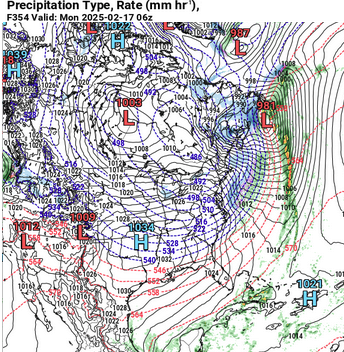
Tracking February 6. Light to moderate event potential
Typhoon Tip replied to Typhoon Tip's topic in New England
Will and I mentioned back and forth last week that as we head thru these first two weeks of February, that model performance was going be challenged. In this case, crucially what is taking place is that the Euro is putting more emphasis on the southern Canada transit of a N/stream S/W and attending low ... I had referred to that low as a primary, but it's technically not that. It's just really the N/stream interfering by bullying wave space into a fragile S/stream impulse. The GFS places less emphasis on that feature in southern Canada, and this creates a bigger synoptic gap, resulting less negative interference, allowing it to generate more coastal response - albeit weak overall, but enough so to put in play more of what people want to see happen. Normally in this situation I'd say there is a 50/50 chance of either; both argument are valid. The reason why I was leaning more GFS, however, was the NAO, which is gone/going negative during that period. This really should suppress the Canadian transit and help the wholesale commit more to a GFS -like solution.. 12z is bumped N like Scott was mentioning, confusing matters because not really doing so because of the N/stream. It's still weaker with that N/stream S/W compared to prior Euro. Then we get into idiosyncrasies like the system moving so fast. It may be that any antecedent cold anomaly in position doesn't get scoured out in time - in which case, any model going west may error some in the lowest level, anyway... GGEM kind of likes that idea, interestingly. It looks like a scalping sleet fest inside a warm sector which is weird. In the end, model error incarnate. The intangible of seasonal trend to be cold, while finding the least amount of actual snow that is physically possible relative to a cold hemisphere, is difficult not to invade one's perception. LOL I get it. It doesn't lend to anything over performing, does it - ...It's not the most sciency thing to say, but regardless the actual cause for that ( I suspect it's simply too much speed/compression but whatever - ), it's hard to knock such a persistent result trend. -
Tracking February 6. Light to moderate event potential
Typhoon Tip replied to Typhoon Tip's topic in New England
Agreed ... most of these facets I've covered in the thread opener. The crucible of time has burned off quality readers/contributors, leaving more and more of this cackling nonsense - it's getting more and more like a Trump rally in here... [ this is an opportunity for the, "you're new to this forum" response ] I guess. I'm not sure what the source of the antipathy is or is felt somehow justified by, but l have more confidence that is is completely out of line and subjectively based on idiocy and thus unwarranted, than I do that this "...2-4 or 3-5" potential will survive verification. -
Tracking February 6. Light to moderate event potential
Typhoon Tip replied to Typhoon Tip's topic in New England
That’s about what I’d expect from this 3-5” if using the GFS it’s about a 4 hr in and out with a couple hrs between 1 and 2/hr rates in the middle kind of thing. things can change tho -
Are you talking about the 00z GFS? if so that’s hardly a “storm”. I mean it’s moving too fasts with only moderate rates. It’s snowin tho - looks a lot like the 6th on this run
-
Tracking February 6. Light to moderate event potential
Typhoon Tip replied to Typhoon Tip's topic in New England
00z GFS continues looking locked on a low transit east of the Del Marva /S of LI, placing less emphases on an Ontario primary like the Euro. Another run with a burst of moderate quick hitter snow … Again … several reason why this type of solution is better supported than the Euro. Provided those remain … makes the 00z Euro run interesting. It’ll be passing thru the 4.5 day lead -
it’s conceivable that we’d get most of the snow this year over these next 10 days to 2 weeks
-
Tracking February 6. Light to moderate event potential
Typhoon Tip replied to Typhoon Tip's topic in New England
I’m not sure what I have to prove? I outlined plenty of uncertainty there -
Fwiw I fired up a thread for this made a case for cooling the Euro future runs but we’ll see.
-
16 already DP 4 nice tick insecticide
-
This is intended to begin specific coverage for a 2-4 or 3-5" type event on the 6th, intending to leave the larger, more interesting coverage for the 9th/10th to a later time. This is actually fairly straight forward scenario. There's been remarkable stability in the recent GFS operational runs for active wave transport along the pattern-fixated polar boundary. Yes, that is likely to be a repeating theme for the next 10 days, but again ... not getting into those scenarios here. Short version: the higher odds for this, what I suspect will cap at a lower moderate mix and/or event, will likely involve areas N of Kevin ... Pretty much Pike to about mid VT/NH and lower Maine. I'm actually inclined, though reluctantly, to invite him to this party ... given to the arguments below. However, in deference to the N tracked models there's a compromise. Longer version: the GEFs mean is slowly inching toward the operational run, which is being pretty strictly guided for where it can move between the stolid S-SE ridge/compressed field, whilst the -EPO attribute/on-going cold loading is pinning the mean polar boundary just S of the N/stream jet into position roughly IND-PHL. This "should" ( famous word usage ) limit the wiggle room to between LI and the Del Marva. Below, we see the GEFs at 18z beginning to bite on this concept, with a clear indication for stressing the pressure field E along that path of evolving/lesser resistance. This is also a bump S and also incrementally more coherent than the 12z ...which was more so than the 00z last night...etc. I'm actually a bit more concerned in this general synopsis, for compression beginning to correct/ attenuate matters. There's that, and the fact that models tend erode 20 or so percent of amplitude off everything... However, in this case we are solidly < than 5 days. It's time for the model to put up or shut up. The GGEM and Euro carry the 6th as well, though obviously those vary toward a more N track and bring more of a brief icing after perhaps a shot of snow. Definitely within the possibility envelope. However, in both the EPS and GEFs derivatives the NAO index ( where in the hell have you been all season! ) is dropping precipitously from +1 now to about -1 SD ... Now, it's possible that the physical manifestation of the block is situated less ideally N in the D. Straight, however... this is still overall a western limbed orientation, so I suspect some limitation to a west/left turning track as a transitive influence - might be a correction coming from the Euro. Lastly, there's a bit of an intangible with this... The very fast bias in the total troposphere lags the surface drag behind, with cold not getting scoured "out" in time prior to the system moving off. If the coalesce to track along and S of LI fails to take place, and this does move west/left of our latitude (SNE), for the love lorn model/storm enthusiasts ... that will likely insure at least a start as snow and then a transition sequence. We don't have a shortage of cold air leading this event, either way
-
I think the 6th is good for a 3-5" type deal ... I may start a thread on that this evening - it's a nice pattern entrance kind of appetizer. I also suspect there's at least snow in the air from the waa pulse tomorrow night but should be low in significance. These are all nail biter needle threaders. I know what your saying about the sinking south with the SPV but I'm also a little of leery of some of these systems falling victim to negative interference thru compression. But we'll see. Hint teaser, part of my confidence is because the NAO is falling negative pretty convincingly, multi-sourced. The NAO doesn't cause these systems, no, but ... it's useful in estimating track configurations. In this case the correlation fading away from early left turners. So I see the eye of the needle as being between LI and the Del Marva, unless the total scaffolding changes
-
Folks 'ill be within frozen spit distance of 0 tomorrow morning. Probably a lot of 6's
-
'Magine if nothing happened ? ho man.
-
The 9th is actually attempting a Miller B in the EPS mean ... It's a rather unusual approach. Typically, that storm type originates from the N/ or hybrid stream coming down the polar boundary, whilst lower +PP is situated over or N of our region, but this mean at 12z is approaching from the WSW. I think I see it though. The jet is still a polar branch - it's just doing a weird circuitous journey through the continent. Also, there is modest +PP N of the region to help enhance baroclinicity but it's in the ambience more so than a nodal surface high pressure whatever too much effort for this range
-
Anywho ... nice to emerge for a change into Saturday morning's coffee and danish time, with such a cornucopia of delicious Meteorological aspects to run through the social media mill, huh
-
Iiiii'd still be leery of the height compression. That shit smearing from southern Cali to SE of the Maritime is real. It's an opposing force that is always there - never mind why You'd rather have the above look than no look...sure. haha. But, it would be nice if that field was more neutral in the means, kind of like on the opposite side of the hemisphere you see above. That, underneath that Hudson node, would be the superior product. Above is 70% of that
-
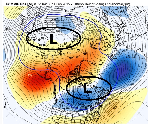
thanks for saying that ( bold ...) ... See, I've been trying to impress to a room full of crickets for ...years really, that the NAO is purely a non-linear wave distributed forcing downstream of the Pacific resolution. In other words, these latter aspect trigger the NAO's circulation modes. Not the other way around... It may not be as much of a misconception as it used to be - thru a decade or so ago it was like a NAO chatty-kathy doll between the 1994 popularizing of it's identity, and the years of tsunamis miss-allocation of it that still to this day isn't completely dead. But when rock star Met used to say the NAO retro will cause an expo... blah blah, what they really should have meant was, the Pacific is hiding it's storm production from the PNA, by non-linear forcing. LOL ...you know, totally clear to everyone - Anyway, this so-far modeled event, with the PV split, appears to be completely harmonically caused, but at large scales. We're just seeing what an exceptionally well-tuned multi-vocal range chorus sounds like when they hit the sweet tone -
-
Fwiw, the split in the PV is evidenced all the way down to the 500 mb in the recent EPS - similar in the GEFs recency as well...
-
I know ...I was joking about this yesterday but partially serious... it's difficult to call out an ice STORM in this compression/high velocity, low residence time flow type. These systems are not standing wave icing events in this flow. Some of them are done in 6 hours. Even at moderate ZR clip, you're just not accreting warning levels - There's a tendency - no shit, huh LOL - to next level all hyperbole at the bus stops of social media.
-
I think what we are seeing there is really an exotic EPO explosion... It's not connected to an antecedent, down welled stratosphere warm intrusion/wave breaking event. If so, one would have happened in early January. So that's fascinating. Lol, I get the feeling folks don't care to engage in the theoretical discussion as to what's enforcing things, rather just getting them to take place... SSW's aside, it doesn't matter how we get there - once there ...that's obviously got an enormous potential to influence the mid latitudes on both sides of the hemisphere with that mobius structure like that. I don't think I've ever - personally - seen that kind of symmetric geometry so clean, so deep, and so removing of noise ... interesting.
-
Straight up is gone negative in the index derivatives, post ~ the 10th. This is, by the way is not SSW related. I know you're not asking or commenting, but I am just side noting: it precedes any perception of a SSW ( much less whether any burst is actually propagating downward, which take 20 days min for the correlation to kick in.. So, when the posters in here inevitably start sharing the gifted insights of the X poster claims connecting the ensuing -AO to all that SSW stuff, please take those grandiosities with a degree of incredulity. This is no statement attempting to abase a -AO. We've seen countless excursions of the AO index over the years, both positive and negative, whence they circulation modes gets there via other means. I'm just tired of the relentless application of the SSW complexity from people that appear to not really understand how it's occurrence mechanically influences the hemisphere.


