

Typhoon Tip
-
Posts
40,582 -
Joined
-
Last visited
Content Type
Profiles
Blogs
Forums
American Weather
Media Demo
Store
Gallery
Everything posted by Typhoon Tip
-
agreed on QPF... I might even go 5-8" but that's a like a run-of-the-mill warning event either way. If the max amount is 7 or 9 ... meh. As far as the 'region wide' - that depends. There are challenges as to the areal extend in these compressed fields. Those constraints can be overcome, but then the low residence time is also a limitation because if the given system is strong enough to extend farther out in radial coverage ... the outer reaches are both less QPF but moving fast - threading the needles are squeeze gigs is what it comes down two.
-
Having said that ... one of these events may over-achieve a little over this 10 days to two weeks. Yeah, sure .. But some of these products look hefty for QPF given a pancaked compression of jet fields moving so fast for this guy
-
Overnighties look like a low end warning event ... I like a either a 60/40 or almost 50/50 blend of the 00z GEFs with the 00Z EPS The operational versions don't actually vary hugely - but two aspects about monitoring guidance... it is both easy to be 'overly' discrete about minute difference as though they mean more than they do (heh, call it lens biasing ), but also, some of that is still needed in a needle pattern. So how much. I feel the 00z oper. Euro was too far N in the cold air so bumping that south looks like a GEFS/EPS blend
-
Haven't looked at particulars but I would guess the GEFs could be too based on that climo track - even if they aren't printing that out, it's an easy modulation
-
Tracking February 6. Light to moderate event potential
Typhoon Tip replied to Typhoon Tip's topic in New England
Yup -
Tracking February 6. Light to moderate event potential
Typhoon Tip replied to Typhoon Tip's topic in New England
These situations where it snowing at sea 20 or 30 or so mile SE of CC while it's pinging and going to zr in ALB, and still snowing moderately in HFD, tend to foster a "tuck" slosh back. That set up is more correlated to the fact that it is quite cold ahead and thus there is a lot of low level mass --> to meso forcing. The models are already coherently depicting a closing beta low down over SE mass about 2/3rds of the way thru this, and when that happens, a cold surge my tumble back S out of S NH. I could see the snow burst going to a freezing drizzle in that cold slosh as the top of the inversion remains saturated. Yeah, the front scours it all away and that's probably unavoidable. But this is a gainer -
The EPS has also shifted south. 120 hours is coherently S of the 00z at 132 - which I would think really matters, because this EPS solution is far enough south that given the amount of cold air prior to this one's arrival, this solution is likely a moderate impact snow event "as is" ... and like the comparison between the GEFs mean and the operational GFS, this to is south of it's operational version. interesting
-
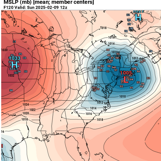
To each his / her own but 3-5" glazed over with zr ... It's more than insignificant. Shear impact to society sort of validates the former notion in my mind. Anyway, this one for the weekend: I find it interesting that the ensemble mean of the GEFs vs the operational GFS are opposit comparing the this event in the foreground. The 6th has routinely had the ens mean NW of the operational guidance... Contrasting, the present ensemble mean is pretty significantly south of the operational - so the modeled circumstance in reversed. It's hard to determine if this is true with the Euro cluster but perhaps to some lesser degree it appears to be so per 00z. In any case, the GEFs move a 1000 mb low S of LI, to between the BM and CC going toward 995 mb - we've ... or I've been comparing the 6th and the 9th as sort of twins but this GEFs behavior does have greater implication, if not hugely so ...some.
-
Tracking February 6. Light to moderate event potential
Typhoon Tip replied to Typhoon Tip's topic in New England
probably not worth as much to point out but the 12z ggem looks primarily snow along and N of the pike, with snow in CT/RI for at least some of the front game - an overall colder profile comparing to its 00z run -
Occasional Thoughts on Climate Change
Typhoon Tip replied to donsutherland1's topic in Climate Change
https://phys.org/news/2025-02-degree-global-triple-area-earth.html -
Occasional Thoughts on Climate Change
Typhoon Tip replied to donsutherland1's topic in Climate Change
There may be a sense of transient empowerment in the "denialsphere," That's more intuitively expected really, during the weeks...months, or year post the inauguration of this particular administration. It rabble roused among the court yard ignoramus pounding fists to a heaven that is trying to remove them and they they're oblivious. A mistake to deny climate change. You don't get it. You don't. But you know what ... Fermi Paradox explanation really has a cocktail of contributing "Holocaustic methods" ...Being mollycoddled over so many generations, such that the humanity of this post Neutron Era technological empowerment, get the right/entitlement/luxury of flouting advice is a verrrrry dangerous game for humanity. It's most likely, an 'end game.' "Neutron" milestones are those like the harnessing of fire in human pre history, to the steam and eventually internal combustion engine, to Watson&Crick 'double helix', to the General Theory of Relativity, to the splitting of the atom and the Neutron chain reaction that leads probably to a local scaled holocaust if not one involving the whole globe..., to AI and soon QC ... These are truly transformative, increasingly more god-like powers. Human innovation has vastly outpaced any checks and balances - like those that are built into all other species of life on this planet, which are evolutionarily constrained into and thus by their ecological niches. We don't have the intelligence to steward this world for these powers at our disposal, by our own ability to design and command. Human innovation will become one of, if not the, most powerful destructive forces ... ultimately natural disasters to ever befall this planet. Denialism? - it's just another cog in the gears of making sure these d-day clock aspects actually machine our demise. It doesn't matter if you deny. Or people cry. There's too many other things to worry about. You're wasting your time. We are even to listen to you. Because you are not right. You are objectively wrong, and are apparently lacking the intelligence to even begin to get what objective means and why that is. So be it. We are not in the business of suppressing anyone's opinion. We are, however, quite within our rights to completely ignore the lunacy of the obliviously abstinent, self-destructive rabble. -
Can we start the 2025 ?
-
Tracking February 6. Light to moderate event potential
Typhoon Tip replied to Typhoon Tip's topic in New England
I don't think they, or anyone else for that matter ... ( so I'm alone on this one, what's new haha) are also considering the speed of the system nuance and the fact that it's out-pacing the time it takes to remove a cold boundary layer... -
Tracking February 6. Light to moderate event potential
Typhoon Tip replied to Typhoon Tip's topic in New England
Me old favorite FOUS grid ( NAM) has an impressive .5+" liq equiv in one 6-hrly period, between 48 and 54 hours at Logan, and all temperature sigma levels are -1C ( 980, 900, 800 mb). There may or may not be an elevated warm layer; if not, that's a wall of S with at least an hour or two embedded where approaches S+. Gotta figure west of the city out along say Rt 9 and the Pike out to Springfield would pound for a time given these grid interpretations. -
Tracking February 6. Light to moderate event potential
Typhoon Tip replied to Typhoon Tip's topic in New England
Looks like what the generalized perspective offered on this last Saturday. Deposited all interpretive peregrinations since … still a 2-4 or 3-5 scenario. That should be advisory in headline scale. However WAA bursts can sometimes overperform … -
Tracking February 6. Light to moderate event potential
Typhoon Tip replied to Typhoon Tip's topic in New England
I’ve been mentioning this but in a sense the speed of this thing moving through appears to outpace the drag/‘scour out’ rate. That said … if a meso or preform beta low forms and moves under that would then put the kabosh on warming the interior before it’s all in the books -
No problem from me. I said 2 weeks ago when this started looking encouraging via the various methodologies ... that we are being enabled in our hiding from the truth - so to speak. 'All winter ... ' 'everything's the way it should be'. yeah, riiight. Despite anyone's personal belief, the objective reality is that CC has claimed enough of our tendency vectors, that as soon as we close down the cold source into mid latitude N/A the NE Pacific circulation mode - I even annotated charts to show, "...As long as this feature is there, winter is within reach" - it's perpetual autumn. While it is there, it is easy for people to either not be aware, forget, or just flat out deny that we blow torch ( relative to normal...) at a higher pitch than prior climate generation, and do so more and more dependably. And it shows... Those weirdly extraordinary heat bursts in February and March since the earlier 2000's, taking place regardless of antecedent established long and short telecon correlation biases, ... are a part of that. etc etc. Just as much as the "cold" January turns out to not even be appreciably below normal across the total subforum - somewhere in that reality is a cold pattern that can't quite get it done. Oblivious though... So, hey ... as long as we're dumping -25 C 850 mb plumes through NW Canada and spreading them out to 45 N, we can bury our head in the winter sand of it all, like a cat hiding their head in a brown paper bag while their tail and ass sticks out thinking that is their world and they are all safe. LOL ...seriously, my cat used to do that when it gets scared. It's pretty funny
-
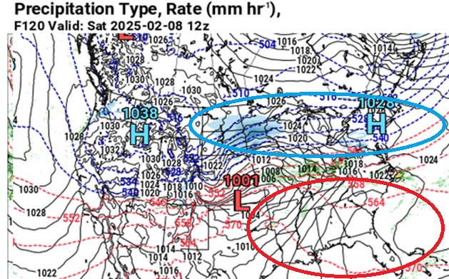
The weekend is less clear for the southern 1/3 to 1/2 of this sub-forum. Yesterday it was more clear; that clarity has been disrupted overnight by a trend to push the low track farther N. It's right on the door stop at this point from being a full breach warm intrusion for MA/CT/RI; but for now, we we're narrowly escaping with minoring mix ending as liquid rain S of VT/NH. In fact, with 552 dm thickness, and initially a WNW flow ahead of the cold front Sunday morning that I'm seeing in the Euro and GGEM... if the sun comes out in that region there's going to be awesome rise/appeal to the air mass for several hours as it is. Up there you'd have to correct this - by the way - weak to middling system more so before this becomes a problem for you. We'll see if the things settle back S -
-
Notice how that took place in a relaxed deep tropospheric, lateral gradient in the non-hydrostatic heights too - there's a 975 mb low under that. We can't seem to get this over on our side of the hemisphere in recent years. If/when it is cold enough for winter events, the cold itself seems it cannot evolve to middle latitudes without compression/velocity saturation. Cold seems to always arrive with base-line negative interference. What we need is for more of the gradient to be in the hydrostatic heights (the "thickness"). Not the other way around...
-
Again … very similar in size and duration as this event on the 6th.
-
Tracking February 6. Light to moderate event potential
Typhoon Tip replied to Typhoon Tip's topic in New England
Ha... that's an interesting thought. I was haven't considered them in aggregate. I've see that only once around here, though ...way back in the late 1980s. There was a nondescript icing event and then it got cold. I remember still hearing that crinkling sound when the wind would blow through the trees like 4 days later. Then, there was a nor'easter brewing and there was concern for wind and snow loading on the ice but it didn't actually become an issue. -
Tracking February 6. Light to moderate event potential
Typhoon Tip replied to Typhoon Tip's topic in New England
Unfortunately ..this event isn't likely to produce much of either. 5" of snow is likely tops. .35" glazing where/if all ice. -
Tracking February 6. Light to moderate event potential
Typhoon Tip replied to Typhoon Tip's topic in New England
That's a nice comparison to 1994 ... I think we must've talked about it before as memory serves, but one of those systems was an IP carpet bombing while heavy blowing and drifting OEs banding was pummeling underneath. Strange. It even came out as far as Acton where I was living then, and I remember at one point we had 1/4 mi vis from breezy 20:1 shattering snow, while the sound of hail on the car tops. I'd never seen that combination of ptypes and haven't really since. -
The Euro's 12z, 120 hour layout is right out of a mid March winter storm set up... HUGE thickness dipole across the eastward extension of the polar boundary - March's and even latter February's this gets to be interesting. Here we are signaling why storms at that time of year can once in a while, massively over-achieve. The only limitation to this one is likely to be the attending S/W is probably being attenuated for moving through a very compressed field, otherwise, in principle, that could be a very dangerous set up. As is, it probably means that it would likely over produce where ever it is precipitating as the storm formulates through that gradient pathway -
-
Tracking February 6. Light to moderate event potential
Typhoon Tip replied to Typhoon Tip's topic in New England
Not quite as cold as the GFS but damn close ... Close enough that I suspect we could be coalescing a consensus. GFS has moved maybe 70 total miles in 3 days of guidance. The Euro's getting away with not moving as much as it's just cooling everything off - reluctantly getting to a similar result. The surface PP in the Euro solution looks more like it's bending around BL cold forcing than "admitting" the GFS is right about a low down there... haha sumpin' li' ghat


