

Typhoon Tip
-
Posts
40,583 -
Joined
-
Last visited
Content Type
Profiles
Blogs
Forums
American Weather
Media Demo
Store
Gallery
Everything posted by Typhoon Tip
-
The GEFs did trend N of priors this morning by enough to alleviated some deterministic uncertainties. Another tick and it'll be on par with the 00Z EPS.
-
GFS misses with a real big one on the 15-17th potential... Just moving the interaction timing a CH and we're correcting any perception of this winter in the absolute sense. Problem is ... the fast flow should really prevent the phase so ..it's like a baked in face smack limitation. haha
-
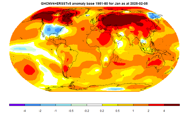
Is that real tho ? I mean I don't doubt that it is but I just went over to NASA's interactive page that runs the map request for GHCNv4 Tv5 and it says it's not available for Jan 2025 Do you have another link ?
-
Basically that’s metaphorical to us having won a cold raffle …
-
Hahaha ! how enabling -
-
kind of aggravating ... because it has hindered matters without any room for doubt, for years now ... This is not the first discussion over this. Forget that, we should all have PHD's in this awareness just by proximity to life in this shit-show by now. Plus, some of us here have clearly been wasting our time instructing this stuff for the course. I'm a pissy cynic about it... but I cannot help but see it sometimes that people filter out/elide/ignore contents if/when they don't sense that it is what they want. It's a good thing no one's getting graded in here. HAHAHA. Anyway, yeah ... the whole pattern has the caution flag baked in for compression and fast flow limiting curvature and zonal forcing circumstances. yup.
-
6" is too much given unmistakable and objective trends. That said ... trends can reverse. That's what we're hoping for a winter enthusiasts. If that happens...sure. Part of the problem is not just that the system is trended(ing) S... The problem is in understanding the structural limitations of a compressed field and fast flow, limiting the N-S extend of any system for that matter. Then adding consideration that this one is not a strong one. If I were Brian and Jay ...this is already a modeled a dim sun cirrus smoker Realistically... ? there's nothing wrong with keeping the higher ends down.
-
Ha. That QPF field is probably just a virga event for NoP in that run.
-
It's safe. I mean, protecting one from the unsavory circumstance of having been d-dripped along by bullshit is a very adult thing to do. Heh ... that super hot flirtatious waitress isn't really that into you Seriously though, conserved approach when there are so many valid reasons to be conservative -
-
Actually ... I'm also a bit skeptical on the higher amounts of the 8" range just looking at the ensemble means. This is not a very intense storm. We want it to be on the N side of the climo track now that I'm thinking about that; while not being too close to where it starts going the other way.. This is what it means to negotiate needle thread circumstance. That's exactly how one has to fiddle with the guidance implications ( btw). If the storm were slower it would probably be stronger by virtue of having been born out of a less compressed field ... so it would spread its goodies over a larger area. The GEFs are just flat out too far S for a 998 mb low frankly, to really correlated more than 4". If the QPF is saying otherwise given below ...it's destined to tone it down as this nears. The EPS is better ... *HOWEVER*, the entire Euro cluster has been too far NW with modeled cyclone tracks since this pattern foot became established. That could be a caution flag for which team has error in its favor. Having to compound all this with storm speed and lacking duration and this and that it's dicey for higher numbers. So ... we'll see if there are any future short term wiggles that help.
-
Tracking February 6. Light to moderate event potential
Typhoon Tip replied to Typhoon Tip's topic in New England
OT, I never had a snow day in the 1980s ... Not once. Of course, that was a different cultural era - it wasn't just for dearth of snows. But there's still no mistaking, the trigger gets pulled ( starting about 15 years ago ...) at least excuse imagined when preceding pretty much anything in reality nowadays. I used to think that's because our society has evolved to be litigiously preoccupied, always looking to sniff ways to f-over some one or something else to compensate for their own stupidity or just bad luck, or both ... Eventually ... institutions had to evolve to protect themselves from lawsuit giddiness. Ha. But I wonder if there is also a "day off" undisclosed sorta motivation going on. Because unless parents really are working for some unforgivable p.o.s. employer, they can pull the 'have to be with the kids' card. Raising kids is complex... it's easy to hide that motivations behind a litany of reasons why this would require not doing one's day job along with the kids staying home. So it's very difficult to prove that mentality is part of it. lol I'm also kind of cynical so tfwiw - -
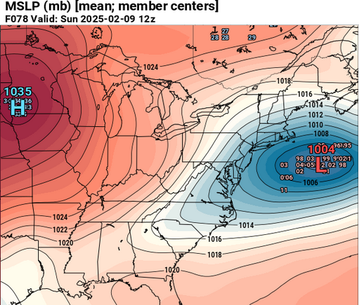
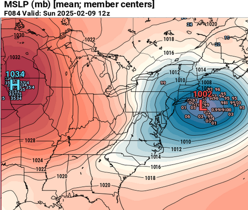
The operational Euro from 00z depicted an unusually high efficiency QPF "explosion" for lack of better word, from an excessive isentropic lift, overnight between Sat/Sun. One of those morning's where a new 8-10" had abruptly occurred, and blue tinted light cleaves through curtain like a gelid peep hole from inside an igloo. Big short duration snow rates .. .Somewhat reminds me of that Dec snow in 2007 that was supposed to be 3 or 4" then IP/ZR then a light rain finish, but it positive busted on the snow side to the tune of some 10" - major ending with freezing drizzle. Never saw 32. It seems to be the only guidance with that scale and degree of proficiency, and it is a rather detailed aspect that may not survive the 3 day's worth of model runs yet to come... so by virtue of that reality as it stands now we'd have to consider that low confidence. That said, the system is quintessentially propagating - albeit fast - along the climate track that correlates well for snow from SE NY to S ME in the operational blends ... something like HFD to ASH along that axis, even without that specific Euro efficiency... either way. Unlike this event today, this 9th one is much higher confidence at this point just because of the stark continuity in the guidance et al. Whether it is 4-6" or 6-8" ... meh. I lean low end warning still and we'll see if some kind of exotic 5 hour, upper tier anomaly starts looking more likely in future runs.
-
Tracking February 6. Light to moderate event potential
Typhoon Tip replied to Typhoon Tip's topic in New England
I feel like for this particular winter this is kind of a 'nadir system' Doesn't have to be a stem wound coastal bomb like in 2015 with that 5 F juggernaut, 978 mb low going by to make the point. It was 8 this morning when the u/a deck capped the cold, and now it is 14 with est 3/4 mi vis of straight down micro dendrite bundles. [edit, now slightly bigger aggregates and est 1/2 mi vis ] I had mentioned some time ago in this thread that part of this system's advantage was in fact it's translation speed; it is outpacing the surface lag. By the time any WAA could scour this slab of low cold, it's long gone. The systems going forward appear to be on the polar side of the boundary so may be safer. Not sure they'll be this knuckle stinger cold at onset. -
"The world warmed to yet another monthly heat record in January, despite an abnormally chilly United States, a cooling La Niña and predictions of a slightly less hot 2025, according to the European climate service Copernicus." https://phys.org/news/2025-02-la-nina-eases-earth.html
-
Tracking February 6. Light to moderate event potential
Typhoon Tip replied to Typhoon Tip's topic in New England
Right in 4 runs it’ll be over - I bet it’ll nail it ! -
20 … there are people about to graduate from college born after 2004
-
sorta yeah. There's actually a line up on a 2 to 3 day periodicity. It's not impossible that we're clock punching advisory and/or low end warning scenarios out there. It's very 1994 esque pumping off an ensemble line. It's physically a way to exhaust an energy saturated hemisphere when the flow is too fast for big dawgs. We could also get screwed by one or two missing, but there's 4 in the pipe line to consider so missing one meh The one the 13th looks the most impressive at the moment (notwithstanding a 6-8" 9th) but there's another on the 11th that may slip S before, and then another that showing up out between the 15-17th. 6th, 9th, 11th, 13th and 16th ... Kind of unusual but like we said, we're not talking systems so big that it makes it unrealistic to turn it over quickly. Fun pattern for winter enthusiasts... Ha, we pass out of the solar minimum on the 8th too LOL
-
Tracking February 6. Light to moderate event potential
Typhoon Tip replied to Typhoon Tip's topic in New England
NAM QPF is now under .25" liq eq at Logan. If that fugger coups that's be a hoot -
At 10:1 snow ratio. .1" liq = 1 inch of snow. SO, that's 7 or 8" above. just sayn' Extending that 10 to 12 would require 15:1, then combining that with compaction after the first couple of inches ... it's probably not making a foot.
-
Yeah I'd try to tone down the intensity of your d-drips if/when taking this thing to the next level. There's plenty of reasons why that run might be 20 or so % too much. I'm still in the 6-8" camp for now.
-
Euro looks initially like it'll be S of prior, how much so notwithstanding
-
13th keeps popping up... this GFS run is a foot of snow. It would be because this one is not a straight shot from the west along a narrow inclusion field, it's coming up the coast as a quasi Miller A - but by virtue of source ( most importantly ...) has a pig ton of PWAT to lop over the polar air mass ...
-
I thought the GGEM and GFS were close to identical ... It's pretty awesome from outside looking in on this thing, considering the last 10 years of everything under the sun in this maddening field and engagement ... to ever have two models in such tightly coupled appeal at still 4 days lead time. We'll see what a crank-in-butt model Euro has to say here shortly. But the GGEM/GFS either in blend or alone look like 6-8" entry into winter storm headline club
-
Tracking February 6. Light to moderate event potential
Typhoon Tip replied to Typhoon Tip's topic in New England
12z NAM has a really warm layer at 800 mb now over Logan that previous solutions did not have 30020969563 08014 151317 42999500 36022982927 -2109 050303 49010207 42000962729 06211 042417 46000204 +7 C seems bit much... but if that happens and there's only .2" liq up to that point, Boston proper would net gain probably 0.0 out of this piddling piece of shit event. On a general note, this was never more than a 2-4 or 3-5er - it's in the bold writing at the thread onset. But there's more to it than just that. This event has sneakily attneuated by 15 to 20% of amplitude compared to when it was in the longer mid range. We been over this a hundred times over the last 10 years, the models tend to magnify amplitude and then correct down some as the come into nearer terms - perhaps this is just that taking place. It's taking a low impact scenario and injuring it more, though. -
Fwiw, that actually doesn't look that bad for me ... I see "probability for >- 12" spanning two weeks of time on this product? Cumulatively, we seem likely to receive at least 3" a pop from 4 pretty easily identifiable events in both guidance and method. I guess capping at 70% might be a conservative approach, too.


