Typhoon Tip
-
Posts
40,581 -
Joined
-
Last visited
Content Type
Profiles
Blogs
Forums
American Weather
Media Demo
Store
Gallery
Everything posted by Typhoon Tip
-
The annular mode has plummeted deeply negative … .. that may also have something to do with it
-
Here you go Jerry... https://www.atmos.albany.edu/gopher-local/albany/FOUS61
-
hahaha... word! I don't think of bonkers as is 1" qpf I guess. So there's some subjectivity there as to what the AMS Glossary officially codified definition is for that word. lol But it's .96" there on the FOUS qpf column. 30000537959 01925 221910 32999290 30021969247 03418 201309 42999598 36025959049 08925 151309 35989292 36064988921 13113 080511 47009803 42045975604 01020 090213 29999489 42011933520 -3423 103512 39009594 48006755203 -2516 153409 22009387 48000683119 -4324 183211 31019493 I just don't like the hyperbolic lean on everything in here. It only adds to the insufferable mania when something works out as a decline.
-
yeah, that's what I noticed - it's just a function of better organization. how or why drives that nuanced difference, unknown.. but that's why the shield looks and is denser above the polar boundary interface - stronger everything. It didn't go "bonkers" though. It's better, but this is still constrained by too fast of an event - so I'd just caution folks from going too much d-drip.
-
I don't think that's ever a possibility in this. This is narrowed impact corridor from a system moving straight west-east across the continent. The jet structures aloft are not impinging that way. In general, it's got some dynamics; it's more a question of where the moisture is coming from for the QPF because the back ground synoptic circumstance suggests drier is supported. That's why we should not be quick to drop the NAM's drier profile - but again...I think there's also folks overdoing it on the dry interpretation - part of the 'oh god oh god' manic thing. haha. Anyway, I just pointed out that the NAM's total QPF is doable for at least an advisory event, given to .3 to .45" liq equiv dropped through an arctic medium.
-
Here's the NAM FOUS grid QPF for Logan ... .43" liq equiv total... At 20:1 out west of the city ( assuming high ratio) that's 8" 42008959143 06924 151009 35979292 48029975705 03721 110212 28999490 54005764704 -2418 153409 23009388 Maybe the ratios won't be that high. Looks like there could be a "ratio gradient" too.
-
Fwiw, the NAM's not blanking the surface .. it's just offering a solution no one wants ( obviously...) to consider
-
I doubt there is a complete whiff in this. The low is triggered initially along the b-c axis because there's a lot of gradient there and the subtle increase in difluence as the jet compression/velocity increases over the boundary leads to wave genesis. But this is actually well ahead of N/stream S/W that is torpedoing along 45 N... This N/stream aft feature eventually catches up to this wave ...eventually giving it a boost in strength once it's long gone, but in the process of closing the gap it's probably going to ignite lighter snows lagging back - pretty much the only way to get a lag in this synoptic speed shit. Anyway, the NAM pretty clearly shows this taking place ... It's not a lot... but, that's 1-2" ...maybe 3", which eliminates the whiff, if using the NAM-like take on this.
-
I think the NAM coup on the last system - I snarked that the night before if in jest but ...heh There are inherent limitations in these compression/fast stream patterns that we go over, and over, and over again ..., but no sooner do the models show something that's above the phenotype for those limitations, there's this elided perception that takes place. Ha haha .. ... I guess the court yard rabble has always demonstrated a willingness to operate within the confines of restraint, huh - I don't know. Maybe the NAM is wrong this time. Just because there are limitations doesn't mean it can't be overcome - knowing when that is can be art.
-
Yeah, I'm not sure I disagree with this bold... I mentioned to Will yesterday that I thought this was 4-6" NoP and 6-8" SoP, but that could be generous by the time we get to S NH. I'd also add that this is done in 6 hours - speed of the system and low residence time . However, I also wouldn't be surprised if what Scott's saying might distort things... This is going to be 20:1 under the clouds so if the DGZ doesn't then pass through some elevated warm layer, this system might "lie" about the significance of it by stack efficiency. LOL
-
Oh shit I'm never disagreeing with that in a CC canvas attempting to usurp a fantastic winter stretch: the collateral damage of that epic war is probably messy systems ... just in principle. Also a manifestation of the war is the compression that seems to be predominating every base line/winter hemisphere since the 2000s, too - but that's going down rabbit hole.
-
I'm just citing what the numerical teleconnectors are correlating as of recent days. The -PNA underpinning with a strongly negative NAO over the western limb, does not permit ( typically ) low positions moving through the Lakes. But I suspect you're just being euphemistic lol S/W don't bounce of ridges ... ? They are either absorbing into the flow by destructive interference, or being emphasized by the flow due to constructive interference. This behavior is manifest by S/W attenuation, such as moving the wave space through a compressed medium ( for example...). Conversely, it may look like a ping ponging but what's really taking place is the S/W is taking pathway that is constructive interfering wrt to where the L/W axis really is anchored. And this can all be partial too - which becomes a head game of how much so... I've seen weird interference patterns where the models look to attempt to send S/W against the larger wave space mechanical layout, but where that usually morphs/corrects is the old squeeze play. Low moves up Michigan and slams to a halt and starts vomiting smaller waves along the east extension, and/or if the primary is BUF ... a Miller B is an option. This is all idealized too - I'm sure there are anomalies relative to anomalies, couched in yet bigger anomalies like a Russian Nesting doll of misfortune, too.
-
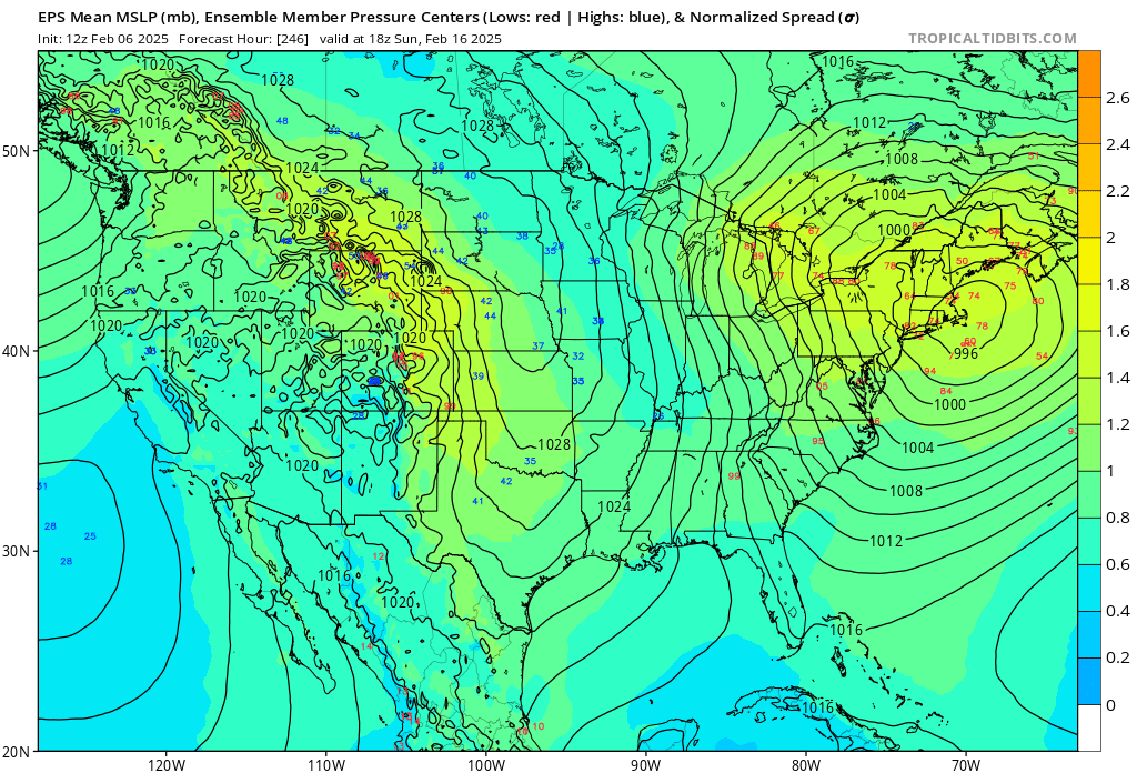
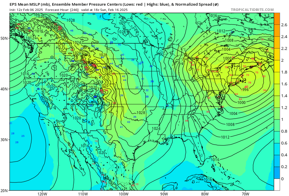
I suspect that is in error... I think we're talking about the bigger event the 15-17th? The numerical derivatives don't correlate very well to early left turning. In fact ... they are opposite. That source implies an east, and by virtue of that also means somewhat south, correction in time. That may not be the case ...it's not a declaration. I wouldn't be surprised. Beyond that, I also think the 13th is a "trap game" storm. It may become that there is a bigger dawg on the 16 or so that's too tempting to captivate the audience, while the 13th sneaks in as a player. Before the big dawg's in Jan and Feb 1978 there was a 1000 mb low up the coast with 19" at Logan in 24 hours. This is interesting because it is more of a Miller A origin, as is suggested coherently in all 3 ens systems... By virtue of that, it will have access to a better moisture source - that is reflected already in the 24-hrly QPF means > .75" even from 160 hour lead - that's a pretty wet signal to be moving headlong into an antecedent air mass that still gripped by 1030 mb polar-arctic PP, N of our latitude when that one arrives. 13th becomes a candidate for over-achieving relative to climo low strength if these synoptics formulate in kind. This paragraph could be the thread opener on that imho - but in deference to the weekend gig ...
-
This run was an improvement. N of priors and more QPF
-
Ha if this were circa 2006 I would at Eastern, with title of ‘possible but above normally ‘ in a heart beat IF we didn’t have possibly two other thread able events after this weekends to consider first.
-
I hadn’t realized that … was heads down at work save what time I spent was focused on the weekend But the 15-17th bomb on the GFS I consider a nod to the EPS ensemble. Btw, the GEFs have above normal coherence too, just 1/3rd of the coherence … which is still above normal for this range.its just that the EPS is exotic
-
all indicators included suggest for me that that is an important period to watch in that midmonth
-
The next couple of frames after that have a clear tendency for bent cyclonic -PP with an extraordinary number of members below 970 mbar considering the range…
-
For ensemble mean consideration, it is very rare to get a signal this coherent at this kind of time range… this also has a positive PNA pulsation occurring in tandem
-
Storm of the season may be the 15-17th
-
yeah honestly ... I'm not seeing differences here that matter from anything when blending all. Moving some parts around inside the average doesn't change the average, in principle. Still looks like a 4-6" NoP and 6-8" Sop deal, but if there is a change in future runs than I'm happy to adjust. One other thing, NWS may have some cross sectional jazz they're using but I'm not sure I see ( otherwise ) where 8-12" come from in this very fast moving open wave. Some attenuation, even if only 5 to 15% is also typical in the final event approach in compression
-
It's actually a tick S at interval 72 compared to the 00z 84. May not be enough to matter.
-
Just being persnickety re Euro but the 66 hour position of the low and PP layout is almost identical to the 00z depiction. It's the QPF field that's a little S, also ... perhaps 10% less Didn't compare the 06z in this -
-
The GEFs did trend N of priors this morning by enough to alleviated some deterministic uncertainties. Another tick and it'll be on par with the 00Z EPS.
-
GFS misses with a real big one on the 15-17th potential... Just moving the interaction timing a CH and we're correcting any perception of this winter in the absolute sense. Problem is ... the fast flow should really prevent the phase so ..it's like a baked in face smack limitation. haha