Typhoon Tip
-
Posts
40,574 -
Joined
-
Last visited
Content Type
Profiles
Blogs
Forums
American Weather
Media Demo
Store
Gallery
Everything posted by Typhoon Tip
-
EPS mean is a tad deeper ( 3 or so mb...) this 12z cycle... Also presenting there are more members on the western envelope suggesting there may yet be corrections toward the NW in general - that's what that metric is used for..etc.
-
agree - and I'm trying to impress that trend is really more important at this range - including the ensemble mean in that isn't a bad idea.
-
Meh, the D6.5 position(s) thru that period are an incremental improvement in track closeness enough to justify the trend continues. The total blend of all guidance now, compared to 24 hours ago, is already a worldly different
-
12z UKMET looks like 3" of snow followed by a 1/2" of sleet mixed with .3" of accretion making whatever clings like glued sand
-
It does but it's less consolidated with the QPF layout ... It's also more nucleated with the low - I don't like that. I've seen this modeled behavior in the past, where it starts hinting at disassociating things and then the next run you realize why. It was because it was trying to fuck the whole thing up and blow it away on the previous run, but it just failed to be bad. LOL
-
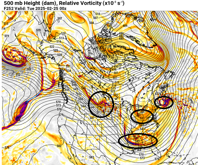
Our much better variant of the +PNA circulation mode nicely showing up in this 12z GFS for the 22nd - 28th. Not so worried about the interference pattern embedded within from this range; it's more likely that one or two of these are real in lieu of this shit hits the fan look
-
24 hours since yesterday has definitely demonstrated more attempts in the better marriage side from what I'm observing. For the record, I don't ultimately like this set up - there's just not enough canonical western flow aspects over western N/A. Thus, this is and will remain prone to errors.
-
meanwhile... GFS of course steps off
-
Meeting at work... just catching up but the 12z CMC is much more proficient phase and capture. Large impacter for eastern zones... perhaps as far west as EEN-HFD Trends trends trends ...
-
trend continues...
-
yeah, slightly better phasing in the total manifold of that solution, compared to the 00z. again, this system's yes or no is probably something like 90% related to how proficiently the phasing ultimately is... less and that S/stream doesn't have a prayer at getting up here... but, a better/deeper N/stream entanglement foists it N and then there's a party that leads to our baby.
-
Ah I think it would be interesting to test these assumptions, either way. My personal hunch is that a bulk density on a scatter plot of total snow ( perhaps using the linear average of HFD/PVD/ORH/BOS for each point analysis), would reveal that 6 to 9" should be the more typical climatology. Yes, there are 12" events, but they may be proven rarer compared to a real analysis. Interesting.... we've never down that in here. But, "in here" isn't science as much as it's model induced, dopamine drug addiction hahaha so go figure -
-
Why does it have to be "2'+" ? "Massive snow producer" granted that's subjective but N of 12" is massive for our climate. What's the interquartile density of snow-related storm totals? A regional foot average is probably on the rarer side compared to where the bulk is in that scatter plot. Wherever the bulk average of all snow events is, that's the cut off for massive consideration? At least in my mind. I know in 1977-1978 winter there were a couple of Miller As in late Dec thru early Jan. One of them, I want to say it was 19.1" fell at Logan and set the 24-hour records for snowfall at that location. A record that would be broken several weeks later by the Feb 5-7 juggernaut of course - which wasn't a Miller A... BUT, there was a Miller A wave that was technically captured in that, but it was weak and was pulled N while E of the Va Capes. Anyway, I'm losing track of the purpose of this conversation. Ha. I was just pointing out that it's not really a very good Miller A comparison, when there is this N/stream capture thing going on. The Miller A model doesn't contain that, which is a entirely instrumental in this case for getting an event here.
-
That's probably going be about what this does. Amts of whatever and who gets what, notwithstanding...
-
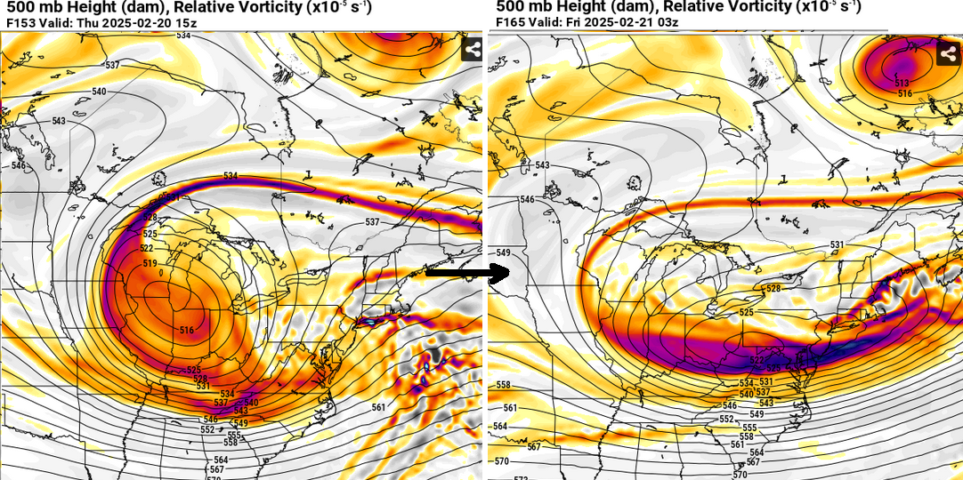
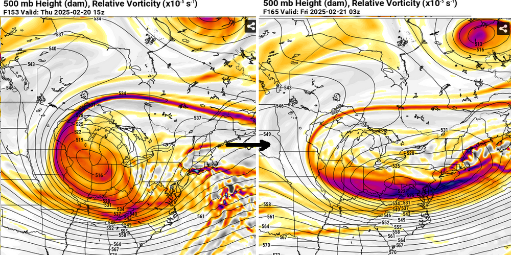
jesus Looking at the NAM cinema you can clearly tell this is coming down to the speed of the troposphere hugely outpacing the frictional drag/cold damming in that fight. By the time the cold would ever work out our area, this things wrapped up already in the Maritimes it's moving so fast. Probably not easy to visualize but relative to just these NAM runs, if the total troposphere were slower, we probably would have just had an easier Lakes cutter with less desire to start a thread - ha
-
both aspects he just stated can be concurrently true
-
I disagree a little ... a little - let's not blow tops off volcano cones here.. This is a different species than a pure Miller A. The S/stream does actively trigger a wave down S... but a Miller A model's total manifold does not have an SPV N/stream timed scenario of capturing and subsuming. That is different than a Miller A in the purer sense - thus I don't believe the correlations is entirely clad. Also, there are Miller A's in history that were massive snow producers. It may be rarer, but they have occurred. I've always been a little bit leery of relying on that idea.
-
It's a little bit of a negative interference offset to this system's total potential. Nevertheless, in so far as the 00z GFS, that solution was not so dismantled that it could not put out a big dawg solution. It just shows it is within the realm of possibility. But this system's ultimate fate is still bit up in the air ( pun hopefully annoying ...) as far as timing these stream mechanics.
-
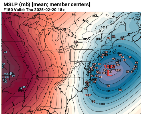
The 20th is a real storm problem. It's going to be on the map; the uncertainty isn't whether a storm is real, the sensitivity as far as I'm observing ( fwiw...) is tightly connected to phase proficiency. Those guidance that suggest more of it, end up more meaningfully impacting/W solutions. It's really attempting a subsume phase type ( 1978 is a spectacular course work on what that cinema looks like - not saying so as an analog in this case ), but there's still a bit of compression and speed bias lingering - mainly because the western heights are not canonically extending polarward enough. It's poorly constructed and the stream lines are also partially fractured ...these constructs signal vague L/W support for this event over the eastern mid latitudes. Such that the wave spacing is being lengthened - you can see it how a partial phase in these guidance is then causing the SPV (N/stream vortex part) to spaghettify toward the E... It's like it grabs the S/stream and then gets it's arms ripped off ...
-
the Euro telecon correlations, when then adding attribution ... is a 70+ F implication by and post Mar 10 the GFS would be too... but it has a subtle sag in the EPO around the 3rd to the 7th... it's not clear if that is really going to be another NE Pac bully or if it fades - we're getting into extended ranges by then that obviously present typically lower confidence. Other than that one concern, everything else from the GEFs derivates might also imply 70+ F by Mar 10. just sayn' not forecasting. it is what it is. But, we have to get through a less compressed, +PNA between the 20th and the end of the month, first... Obviously we have this one on the 20th, which too much time is being spent on individual model's butt bonings and not enough on the fact that the trend was enormous. Then the 25th has been all or nothing. Either the given model has a 970 juggernaut, or it's partly sunny on the next run. So we'll see if that one has legs. Both are a part of a slowly relaxing compression, whilst the PNA flips mode from neg to positive. If/when one emerges more likely with the 25th, that one has the most torpid background and thus slower moving/time to develop "in time" plausibility in my mind. The 20th is a real storm problem. It's going to be on the map; the uncertainty isn't whether a storm is real, the sensitivity as far as I'm observing ( fwiw...) is tightly connected to phase proficiency. Those guidance that suggest more of it, end up more meaningfully impacting/W solutions. It's really attempting a subsume phase type ( 1978 is a spectacular course work on what that cinema looks like - not saying so as an analog in this case ), but there's still a bit of compression and speed bias lingering - mainly because the western heights are not canonical. The wave spacing is being lengthened - you can see it how a partial phase in these guidance is then causing the SPV (N/stream vortex part) to spaghettify toward the E... It's like it grabs the S/stream and then gets it's arms ripped off ...
-
00z UKMET had 9 hours of light to moderate snow NoP FWIW.
-
UKMET was interesting
-
Or if he wants to focus on the low, it’s steadily getting deeper every run the last three cycles, too
-
It’s more amped it’s not a disaster;it’s moving too fast
-
There’s no way for the primary to go into Canada. That’s figuratively against the northwest wall