
DRVTS
-
Posts
157 -
Joined
-
Last visited
Content Type
Profiles
Blogs
Forums
American Weather
Media Demo
Store
Gallery
Everything posted by DRVTS
-
 Been snowing light but steady here in n putnam since 7:30. 1/3 inch on the board. really no virga this am. incoming radar looks decent. I have the "norlun board" in place just in case...
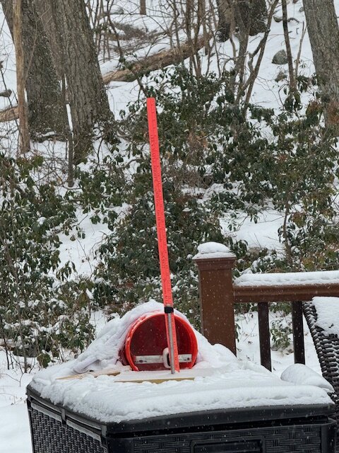
-
Two Mdt to high impact events NYC subforum; wknd Jan 6-7 Incl OBS, and mid week Jan 9-10 (incl OBS). Total water equiv by 00z/11 general 2", possibly 6" includes snow-ice mainly interior. RVR flood potential increases Jan 10 and beyond. Damaging wind.
DRVTS replied to wdrag's topic in New York City Metro
First few feathery flakes in Norther Putnam co currently. Seems early. No virga? -
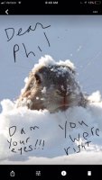
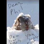
Could we be looking at a "peeper-paster" storm?
-
Did the CCB already move through? Where did it set up?
-
closing in on 6" moderate snow 31.3
-
Wet manglers mixing in temp 36.1 carmel 850ft temp steadily dropping since dark
-
At what point in the storm will the IVT begin to present itself. It seems that it's position will be the difference between 2 and 10 inches. I dont know how the NWS still gives Putnam 6-12 when the forcasted temp never drops below 33 for the entire storm.
-
What will be the over/under elevation number that makes or breaks the big accumulations... It was 32.4 degrees for the whole storm yesterday, and I got 2 inches. (850ft in Carmel) .3 degrees lower would have probably yielded 6-7 inches This storm is like Forest's box of chocolates...you never know what youre gonna get
-
So when does the He-Man's American Weather Snow Weiner Snowstorm Chasing Club have its first official meeting, Imagine this whole crew meeting up and heading to the center of the bullseye with a storm like this? Maybe starting a Snow Storm Chasing Charter company would be a winning business idea as these winters continue to deprive the depraved snow weenies We would be the first chapter.
-
1 inch at 850ft carmel 32.2
-
Shes coming in hot...overperformer?
-
2/13 Light/Moderate Snowfall Nowcasting & Observations
DRVTS replied to Northof78's topic in New York City Metro
Glad you are still checking though. Keep us updated -
if only we were in the bull's-eye seven days ago....
-
37.2 here. Looks like the cold is moving south of Albany nearing Norther Dutchess co.
-
37.2 in norther Putnam Co. Seems about 3 degrees lower than expected at this time. Not sure if it is meaningful, but they have my area changing to freezing rain at around 4am.
-
I say the main roads will likely be ok, but side roads a gamble. The mains will be salted heavily. I think I will close the Animal Hospital mainly due to staff commuting/ many from Dutchess. You should check now and ask if the Dr had any other cancellations next week. That is a good way to get an appointment sooner than March.
-
Icing threat starting to look real and potentially damaging. Get your salt (fyi-avoid calcium chloride where your dogs walk)
-
The true pure-blood weenie cherishes every measurable amount, and looks forward to a better day.
-
Is radar filling in for round 2 over PA?
-
How long can this rotating band stay over us in the HV? it looks like it means to hang for a while the way that moisture is streaming in from the sound and east.
-
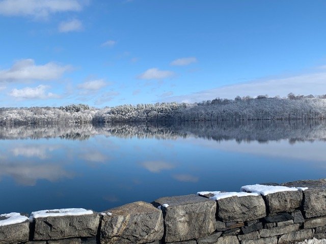
After last weeks ice. Had to stop on the way to work...
-
.8 inches of ZR.? with no thawing all week? That is a disaster if it occurs. Esp because the nyseg trucks have not been mobilized like in past storms in preparation.
-
Minor to moderate winter event M-Tue Dec 16-17, 2019
DRVTS replied to wdrag's topic in New York City Metro
Is that really a possibility That is major power outages, with sub zero temps all week. NWS has not even mentioned that kind of ice event all week, and now still says only up to .2 ZR possible. -
watch out..... Special Weather Statement National Weather Service New York NY 958 AM EST Thu Jan 24 2019 NJZ002-004-006-103>108-NYZ067>075-176>179-242100- Western Passaic-Eastern Passaic-Hudson-Western Bergen- Eastern Bergen-Western Essex-Eastern Essex-Western Union- Eastern Union-Orange-Putnam-Rockland-Northern Westchester- Southern Westchester-New York (Manhattan)-Bronx- Richmond (Staten Island)-Kings (Brooklyn)-Northern Queens- Northern Nassau-Southern Queens-Southern Nassau- 958 AM EST Thu Jan 24 2019 ...A LINE OF HEAVY RAIN WITH POTENTIALLY STRONG TO DAMAGING WINDS THIS AFTERNOON... A line of heavy rain with possible thunderstorms will move in this afternoon between 12PM and 3PM. Widespread wind gusts of 50 to 60 mph are possible with this line. This could bring down tree limbs, trees, and power lines.
-
Any guesses on first flakes. Radar looks pretty far off still. also, anyone know of a good "futurecast" link, like accuweather has on chanel seven?


