Iceagewhereartthou
-
Posts
1,906 -
Joined
-
Last visited
Content Type
Profiles
Blogs
Forums
American Weather
Media Demo
Store
Gallery
Everything posted by Iceagewhereartthou
-
December 8-10, 2018 Winter Storm
Iceagewhereartthou replied to Orangeburgwx's topic in Southeastern States
30-36 hours of pink in the upstate; is that sleet or zr? Anyone have the zr map from this run? -
December 8-10, 2018 Winter Storm
Iceagewhereartthou replied to Orangeburgwx's topic in Southeastern States
Boy a cruel cuttoff for us Oconee, Pickens, Greenville county peeps if that verifies! Unfortunately, that happens often. -
December 8-10, 2018 Winter Storm
Iceagewhereartthou replied to Orangeburgwx's topic in Southeastern States
HP and LP in good tandem at 108, but LP looks like is getting to amped to me, closes off then. HP at 1040. -
December 8-10, 2018 Winter Storm
Iceagewhereartthou replied to Orangeburgwx's topic in Southeastern States
S/w goes from being closed at 72 to almost being sheared out at 90, then looks like it really flares up around Dallas at 102. -
December 8-10, 2018 Winter Storm
Iceagewhereartthou replied to Orangeburgwx's topic in Southeastern States
I believe it's also further north, didn't the 18z come ashore in mid Baja? -
December 8-10, 2018 Winter Storm
Iceagewhereartthou replied to Orangeburgwx's topic in Southeastern States
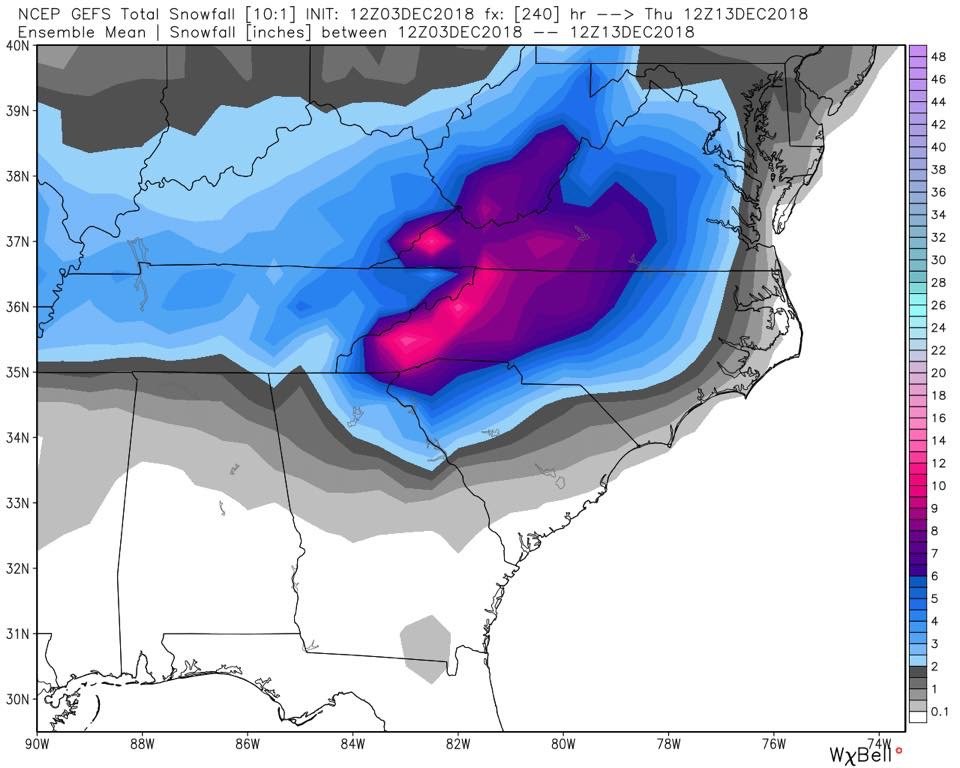
That's crazy honestly, I can't remember seeing means like that at this lead before. Almost all the panels show significant snowfall, although I am sure most of that, at least for CLT and GSP would be mix. Crazier still, is how the op runs have basically left GSP with all rain; how can the op's and ensembles be so different? Something for everyone to keep in mind, in a setup like this with very marginal cold, timing and placement are the whole show; even more than usual when we have better cold air sources. Speed up or slow down one player, 50 miles here or there for placement, or a couple mbs of pressure up or down will change the model outputs tremendously; even up till go time. I certainly wouldn't expect it, but it's very possible a nick here or tuck there could change our output back to a colder suppressed look; it wouldn't take a whole lot. Too early to be jumping ship, even though tempered expectations are wise. -
December 8-10, 2018 Winter Storm
Iceagewhereartthou replied to Orangeburgwx's topic in Southeastern States
High gets pushed out after 126, way too warm, even mtns mostly a mix. Terrible run there! -
December 8-10, 2018 Winter Storm
Iceagewhereartthou replied to Orangeburgwx's topic in Southeastern States
Looks good, just a stronger NE high! -
December 8-10, 2018 Winter Storm
Iceagewhereartthou replied to Orangeburgwx's topic in Southeastern States
Well what we're pretty sure of: - An LP will bring significant amount of QPF into the SE next weekend - There are several key ingredients in play for a winter storm somewhere in our area > S/W, HP somewhere to our north, early season cold - It's climo for some areas such as the high country of NC and VA, and early climo for adjacent areas. There are some other factors that appear to be going in our direction at this time, such as the relatively weak baja low, a bit of a 50/50 low, and possibility of 2 highs; one in the MW and one in the NE. And the fact that most models have been showing something wintry for a few days now. Some things to consider: The Baja to Jax track of a 1008ish LP with a 1035-1040 HP over Pen/NY (and another high over MN) would give most of the board the best chance for a decent storm (with timing considerations). Many of the model runs we have seen have shown deviations of that and even slight changes would yield nice results for some folks, while sticking it to others. This looks to be a high QPF scenario (we're usually trying to scrape a few tenths) with many areas possibly receiving 1-3 inches of it! With high QPF will come a HUGE bust factor based on the temp profile. Cold = big snow (or mix); not cold =big rain (big disappointment). Someone is likely to get a very nice dump out of this, but there will be big gradients in short distances and elevation changes, and lots of heartbreak. As always, NC Mtns and SW VA will have the best chances, and are in great shape for a nice storm. Next would be NC piedmont, Upstate, and NEGA, though the odds of serious mixing increase considerably even if those areas are fortunate. IF we get the trends we need, more folks will have a chance. Right now both the GFS and Euro Ensembles are pretty close (even though the OP runs are wildly different) which I think is pretty unuual at this point. Hope for the best but expect cold rain and we'll see what happens!
-
December 8-10, 2018 Winter Storm
Iceagewhereartthou replied to Orangeburgwx's topic in Southeastern States
I've thought about that one also and that's not good for my neck. I was in Taylor's and saw a few sleet pellets mixed in with the cold rain. Caesars Head got close to a foot of snow- had to go up above about 2500 ft. Lower levels just a hair too warm. A tough one to take in the upstate, similar to last year in that regard. This one has that type of solution written all over it unless that cold press is really strong. Pulling for suppression as long as possible, but it would be against the grain around the upstate. -
December 8-10, 2018 Winter Storm
Iceagewhereartthou replied to Orangeburgwx's topic in Southeastern States
Looks like FV3 is the only model that came in colder and further south. All others came further north and a little warmer. We'll have to watch today's runs to see if that continues. If so, that would likely indicate our NW trend, which this early, would be bad for non NC peeps. My guess is that is exactly what will happen as we approach game time; low will become more amped and/or cold press is less and this is an I77/40 West and elevation storm. That's climo anyway. Hopefully we see a return to the more southern and colder solution on runs today or tomorrow, but it's hard to get that once we start losing it. -
December 8-10, 2018 Winter Storm
Iceagewhereartthou replied to Orangeburgwx's topic in Southeastern States
I'd like to see that low 100 miles to the south and the high 100 miles SW at about 1038 or 1040. -
Southeast Sanitarium - A Place to Vent
Iceagewhereartthou replied to Jonathan's topic in Southeastern States
Here's everyone on the board that gets left out come zero hour next weekend -
Southeast Sanitarium - A Place to Vent
Iceagewhereartthou replied to Jonathan's topic in Southeastern States
Not to mention the mountains tend to set the trend for snow each year, and the storm trends tend to trend well for those folks! -
Southeast Sanitarium - A Place to Vent
Iceagewhereartthou replied to Jonathan's topic in Southeastern States
GFS would absolutely suck for upstate, especially western upstate, but would be much more climatologically likely. Most of NC gets good snowfall while western upstate gets almost nothing, with eastern upstate getting in on the cold before moisture ends. That's about par for the course. -
December 8-10, 2018 Winter Storm
Iceagewhereartthou replied to Orangeburgwx's topic in Southeastern States
That's about as bullish as GSP ever gets, and I don't ever remember that much confidence 6-7 days out. That surprises me at this stage. -
December 8-10, 2018 Winter Storm
Iceagewhereartthou replied to Orangeburgwx's topic in Southeastern States
I also agree with that. And the infamous NW trend, though not universal, is climo, so I think most want to see that suppression continue for the next couple days at least. It's going to be a crazy week of watching to say the least, with some mega mood swings in this thread! -
December 8-10, 2018 Winter Storm
Iceagewhereartthou replied to Orangeburgwx's topic in Southeastern States
That almost seems like an impossible scenario anymore. I guess we did pretty well with Jan 11 storm, but of course our standard is Jan 88. While those totals are pure fantasy, it would be awesome to see a double digit snowfall again, it's been decades for us! Defintiely need this Miller A scenario to happen. Unfortunately, we have to temper ourselves with this being so far out. What are the odds the setup we're seeing today (almost perfect for us) actually verifies? Extremely small I would think. Nevertheless, pretty cool to see so many big dog solutions from various models. -
December 8-10, 2018 Winter Storm
Iceagewhereartthou replied to Orangeburgwx's topic in Southeastern States
Wow, one clown map is bigger than the next! This one will either go down in antiquity or in infamy... but which will it be? I have dreams of seeing one storm like that in my lifetime... just once. That aside, it's hard not to get excited about the runs over the past 24 hours. -
Ok, guess it's the fall wennie in me but I find that I am actually a little giddy about tomorrow night. I seriously have been thinking about the cool down all day with anticipation, kinda like when you have something really cool planned that you can't wait till it gets here. Ok, part if it is that my a/c went out a couple weeks ago and with the heat and humidity, the windows have provided little relief at night. But beyond that, it will be awesome just to have some comfortable, NORMAL weather! Most on the board have not seen temps below 60 since the late August front, even places like Asheville. Low 50s is going to feel so awesome!
-
Yeah, I've heard that before and its a mind boggling streak. I looked it up and Dec 1984 was the last month. Hmm, wonder if it had any effect on Jan 85. Anything happen that month of interest?
-
Ok, believe it or not I actually tried to find the answer! NWS only goes back 5 years, or 60 months, and I don't know where to go to get farther back. I tried wunderground, but I every time I try to bring up the history for GSP it goes over to some site in Peru...? anyway, for the past 60 months - back though Oct of 2013, there have actually been 19 that were below normal - actually more than I would have thought. But still, less than a third. One was exactly normal, and the rest were above. These are the months below for each year since then 2013 - Nov 2014 - Jan, Mar, July, Aug, Nov 2015 - Jan, Feb, Oct 2016 - Jan, Feb, May 2017 - June, Aug 2018 - Jan, Mar, April, July, Aug The top 3 greatest departures below were as follows: 1. Jan 14 (-6.1), 2. Nov 14 (-4.7), 3. Jan 18 (-4.1) Most of the rest were less than 2 below normal. The three greatest positive departures were as follows: 1. Dec 15 (+11.2), 2. Feb 17 (+8.2), 3. Feb 18 (+7.9), nearly twice the greatest cold departures.
-
GSP has not recorded a single day below average since 8/26. CLT and AVL, since 8/25.
-
I was looking at a listing of GSP 's top five warmest for each month, and it shows what many of us have been experiencing and referencing of late; an alarming number of record and near record warm months just in the last few years. Going back to 2010, there have been 105 months, not counting this Oct. The number 1 and 3 warmest Februaries on record, 2017 and 2018 The number 1 and 4 Marches, 2012 and 2016 The number 1 April 2017 The number 4 May, 2018 The number 2 June, 2010 The number 3, 4, and 5 July s, 2016, 2011, 2010 The number 3 and 5 Augusta, 2011 and 2016 The number 2 and 4 Septembers, 2018 and 2016 The number 5 October, 2016 And the number 1 December, 2015. That is 16 of our last 105 months have been an all-time top five warmest for that particular month (with 4 having been the warmest ever)! Even the previous decade, the 2000s, which was a warm decade only had 7 total, and that was a lot. By contrast, we have only had 1 top 5 coldest since 2010, that was our number 5 December 2010. And only one other going back to 2000; number 3 December, 2000. Disturbing trends!
-
In truth, I'm not even asking for "cold" right now. It doesn't have to be 10 below average ) though that would be nice), I would just like to see, you know, average... Just having a little crisp, at least at night, a drop in humidity (like is supposed to happen in Oct.) , a nip to get the leaves starting to change, some of those bright blue afternoons without the summer like feel... Ok, gotta stop, getting frustrated again