Harry Perry
-
Posts
1,030 -
Joined
-
Last visited
Content Type
Profiles
Blogs
Forums
American Weather
Media Demo
Store
Gallery
Everything posted by Harry Perry
-

2022 Short/Medium Range Severe Weather Discussion
Harry Perry replied to Chicago Storm's topic in Lakes/Ohio Valley
Tomorrow afternoon/evening trying to sneak up on us. RAP/NAM show some intriguing soundings with storms firing along the warm front near I-65 northeast to roughly the MI/IN border. -
Mid range/long range solutions backing off on the cooling trend for next week. Was looking like a week or so of 60’s but Euro/GFS has trended toward more 70’s and only one day of 60’s.
-
Spring 2022 Medium/Long Range Discussion
Harry Perry replied to Chicago Storm's topic in Lakes/Ohio Valley
Just got to Sarasota Florida yesterday and we head back next Wednesday.. safe to say that we’re bringing summer with us. Not seeing much in the long range showing a pattern flip back to cold either. Very nice signal, and as I kind of figured - we’ll go from 50’s right to 80’s with a flip of a switch. -
Spring 2022 Medium/Long Range Discussion
Harry Perry replied to Chicago Storm's topic in Lakes/Ohio Valley
True. One good caveat to this prolonged cool spell. The switch to summer will likely be overnight (or seem to be) this year. We’ll be saying “remember last Monday when it was snowing and 34°?” While it’s 85° under full sun and dew points in the 60’s the following Monday. One can wonder anyway. -
Spring/Summer 2022 Complaint/Banter Hangout
Harry Perry replied to IWXwx's topic in Lakes/Ohio Valley
Funny you should mention that…
-
Spring/Summer 2022 Complaint/Banter Hangout
Harry Perry replied to IWXwx's topic in Lakes/Ohio Valley
I can tolerate bouts of colder weather, but one day (maybe 2, if we’re lucky) of average temperatures followed by 5-7 days of 20-30° below average temps is just brutal. -
Spring/Summer 2022 Complaint/Banter Hangout
Harry Perry replied to IWXwx's topic in Lakes/Ohio Valley
GFS showing 30’s for highs throughout the beginning of May. Old habits die hard. -
Ended up with 3” of pixie dust here. Some drifting close to a foot in spots. Nice little system.
-
Two perfect names for future forecast models… 06z POS and PUNT coming in hot.
-
This storm will certainly be feast of famine for some, who is yet to be determined. I feel for the Mets/NWS in times like these. What a mess to sort through.
-
This, this is impressive.
-
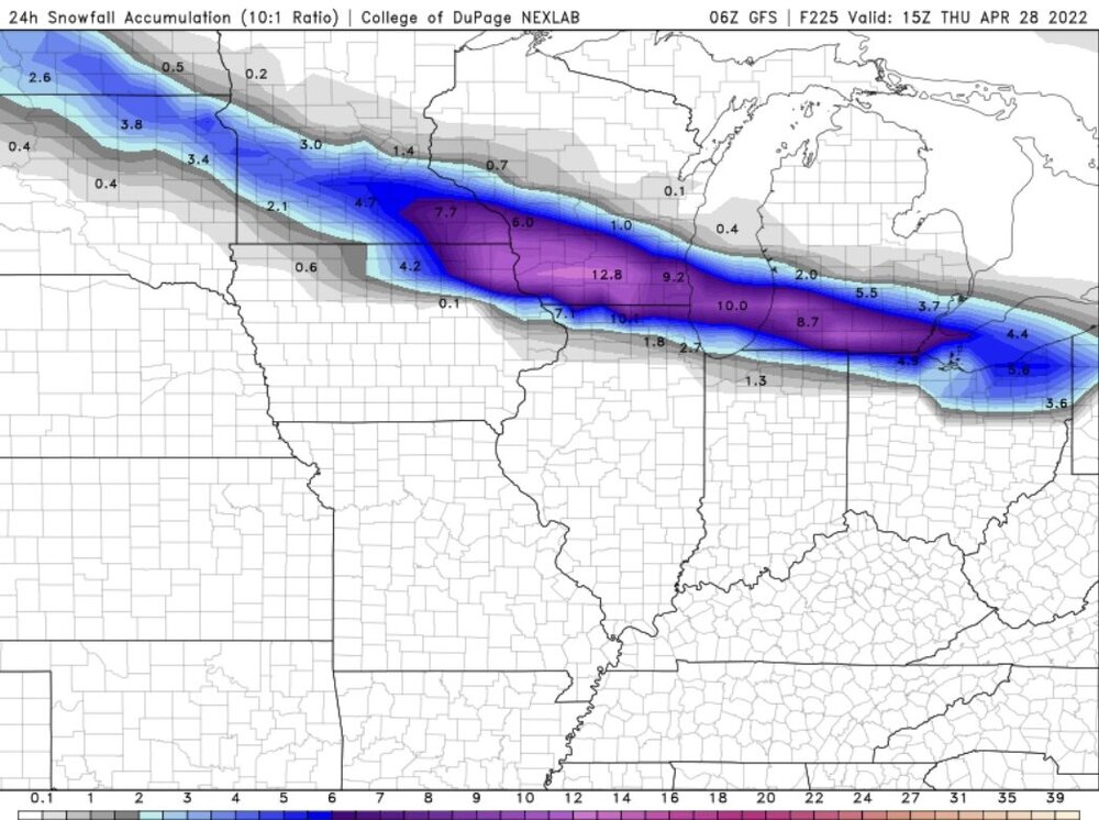
Cold front is moving a bit quicker than previously thought.. at this rate Flat Rock to Adrian point south is in line for 3-5”
-
Those rates would be niiiiice. I’m 33 and think the biggest system I can recall is GHDII. Seems like there were big ones all the time when I was young, but when you’re only 3’ tall… doesn’t take much to have snow up to your knees. But yeah, this system… this one is exciting. Loved how GRR stated this to be a high end advisory yesterday, yet issued a warning today and will likely bust (unless these short range ensembles are correct). They’ll never issue a watch or warning here again. Ever.
-
I remember this. This was one of the events I remembered. The other was 2005-6ish. Dry air infiltration completely demolished the deformation zone snows with a sharp cut-off. Literally nothing but virga and a sharp NE wind.
-
Seems like this didn’t happen as much growing up, but I remember a few times where 6-10” was forecast and woke up to less than a dusting on the ground.
-
I don’t know… this smells like a bust around here.
-
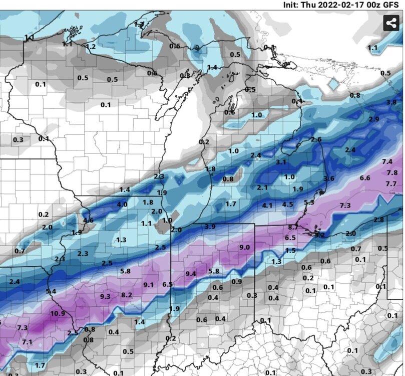
Good call. I’d expect roughly the same over this way. Watch roughly from the I-96 corridor south including Clinton and Gratiot counties with 5-9” totals with locally higher amounts and the mention of a brief onset of sleet/freezing rain in the southern zones before changing to all snow.
-
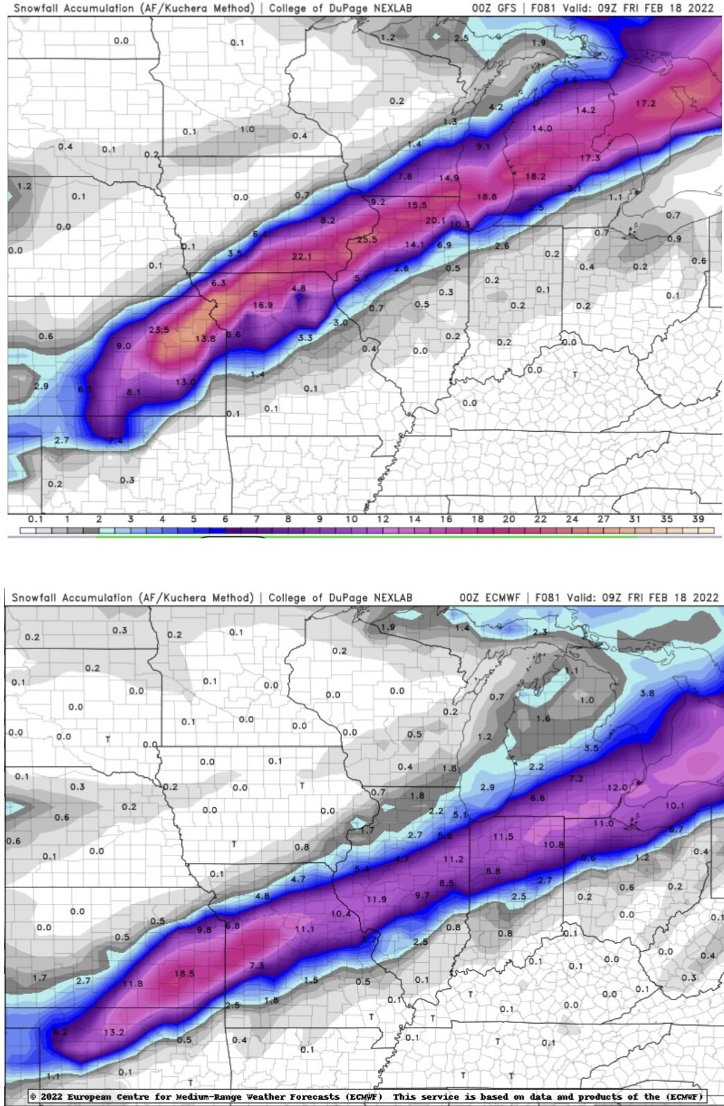
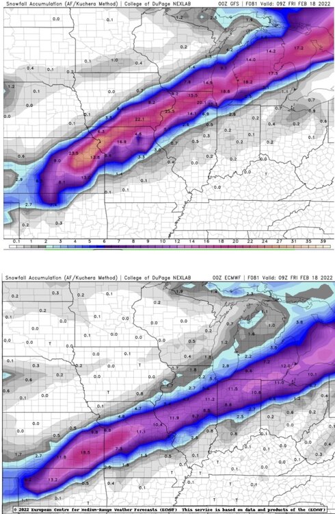
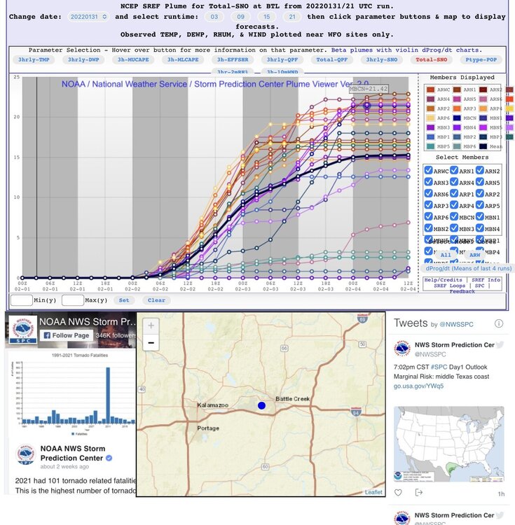
Came up with this. Pretty impressive spread.
-
This. Truer words never spoken.
-
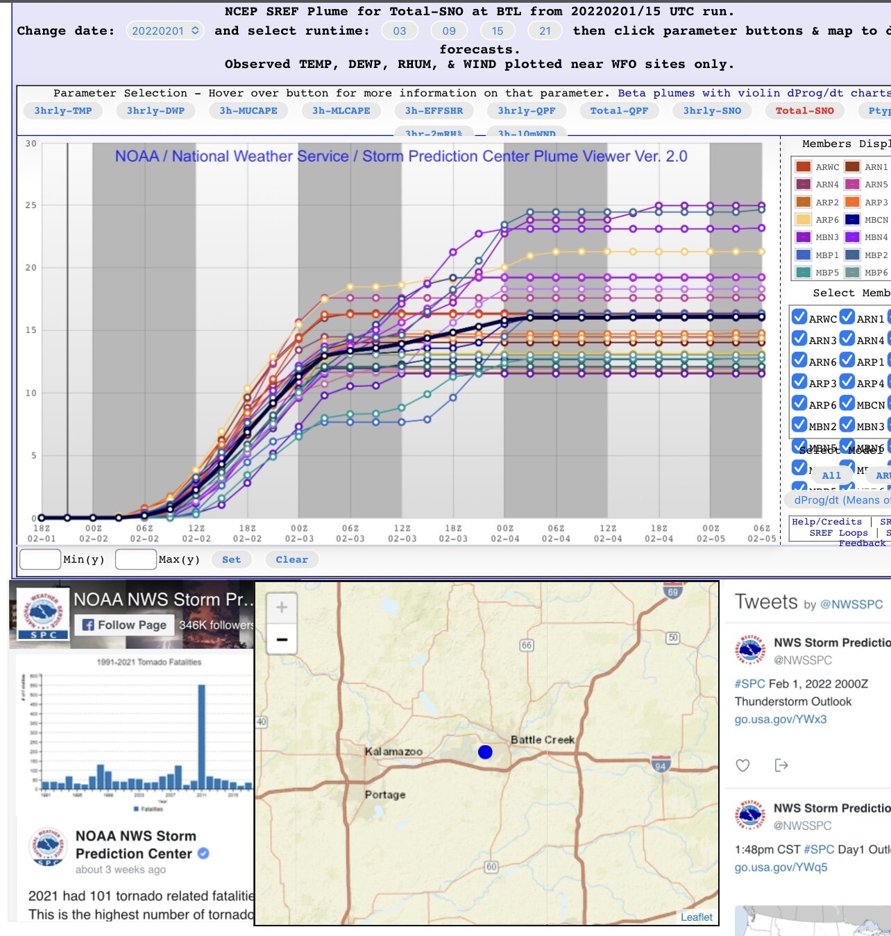
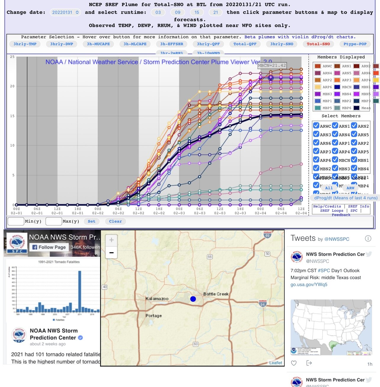
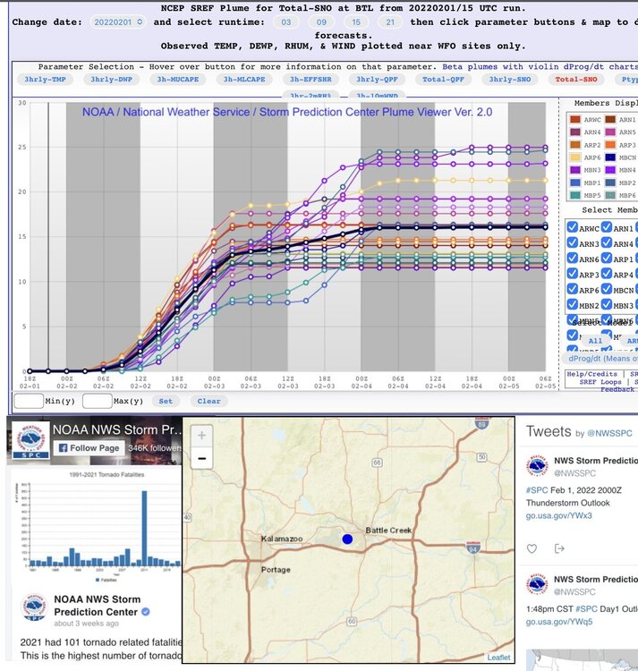
First time I’ve personally witnessed plumes this high clustered between 12-25”
-
Good lookin out… Smells like hopes & dreams in here
-
Currently sitting at a strip club drinking a Michelob Ultra waiting to see the next model suite.. literally.
-
Guess we’ll see what happens in the next 24. Unique event nevertheless. Usually waiting on a sub-990mb surface low to bring us a storm like this.
-
Still makes for some good
-
This. What are we missing here..