Harry Perry
-
Posts
1,030 -
Joined
-
Last visited
Content Type
Profiles
Blogs
Forums
American Weather
Media Demo
Store
Gallery
Everything posted by Harry Perry
-

Pre-Christmas (Dec 21-23rd) Winter Storm Part 2
Harry Perry replied to Chicago Storm's topic in Lakes/Ohio Valley
Everywhere and I mean literally everyone here closing early due to the “snow storm”. Garbage pick up is today and they called it off. No one on the roads/highway. Some ice on side/back roads but all other roads and highway is clear. Very windy, but visibility is pretty good. Filtered sun at times, very little if any snow accums today. Feels like a normal Michigan winter day. -
Pre-Christmas (Dec 21-23rd) Winter Storm Part 2
Harry Perry replied to Chicago Storm's topic in Lakes/Ohio Valley
This is rather lack-luster so far, and the back end of the snow is approaching quickly. Will be interesting to see what transpires, but the 3-6” by 1am looks to be in dire jeopardy. -
Pre-Christmas (Dec 21-23rd) Winter Storm Part 2
Harry Perry replied to Chicago Storm's topic in Lakes/Ohio Valley
Notable uptick for sure. -
Pre-Christmas (Dec 21-23rd) Winter Storm Part 2
Harry Perry replied to Chicago Storm's topic in Lakes/Ohio Valley
I think they’re sitting in a good spot now, I could see an upgrade to blizzard warning if the low continues to deepen more rapidly earlier than expected. Overnight shift or mid morning shift would likely pull the trigger on that. Or if they don’t they will just as the winds begin to die down and the snow rates drop Friday evening - in somewhat typical GRR fashion . One thing to note is (Bill Marino GRR AFD) mentions the uncertainty with 3+ hour of 1/4 mile visibility/less in the WSW zones, but I would say that it’s close enough to more than likely going to happen in the Eastern zones just as much if not more as the SLP deepens over the east side of the state. All headline verbiage and technical jargon aside. It’s going to feel like a blizzard. -
Pre-Christmas (Dec 21-23rd) Winter Storm Part 2
Harry Perry replied to Chicago Storm's topic in Lakes/Ohio Valley
Never a dull moment. What’s your prediction around our parts? -
Pre-Christmas (Dec 21-23rd) Winter Storm Part 2
Harry Perry replied to Chicago Storm's topic in Lakes/Ohio Valley
This. Albeit the November LES event was the most impressive I recall in recent times (over a foot of pure LES), this system will only enhance totals, but it’ll be interesting to measure. Think that might be a problem with 50mph gusts. -
Pre-Christmas (Dec 21-23rd) Winter Storm Part 2
Harry Perry replied to Chicago Storm's topic in Lakes/Ohio Valley
SREF or die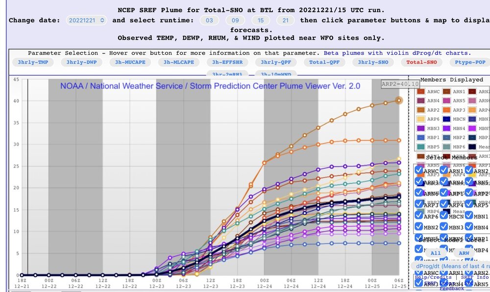
-
Pre-Christmas (Dec 21-23rd) Winter Storm Part 2
Harry Perry replied to Chicago Storm's topic in Lakes/Ohio Valley
Meanwhile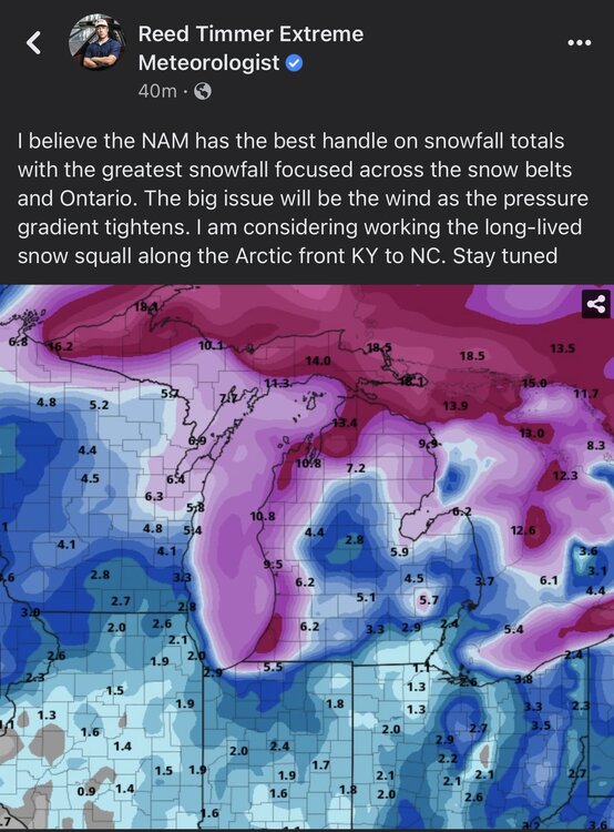
-
Pre-Christmas (Dec 21-23rd) Winter Storm
Harry Perry replied to Chicago Storm's topic in Lakes/Ohio Valley
Don’t throw the towel in yet. This is still 72 hours away. A lot ̶c̶a̶n̶ ̶ WILL change (for better or worse in the next 72 hours) -
Pre-Christmas (Dec 21-23rd) Winter Storm
Harry Perry replied to Chicago Storm's topic in Lakes/Ohio Valley
Bonus on the GFS, shows a decent clipper on the heals of the departing system. Starts Sunday evening and drops a few more inches across southern Minnesota, most of Iowa, northern Illinois, Indiana. Brings more moisture and lift into the DGZ for the LES belts - even with the disturbance passing south of the lakes, enough to squeeze another 1-3” for western lower Michigan, maybe more. Still a long way off. -
Pre-Christmas (Dec 21-23rd) Winter Storm
Harry Perry replied to Chicago Storm's topic in Lakes/Ohio Valley
Yeah, should make a thick crust of ice/slush beneath. Travel will be a nightmare. Nice hearing from you, been a minute. -
Pre-Christmas (Dec 21-23rd) Winter Storm
Harry Perry replied to Chicago Storm's topic in Lakes/Ohio Valley
More realistic, though ratios are cut due to high winds shredding the flakes.. 10:1 still snowing.
-
Pre-Christmas (Dec 21-23rd) Winter Storm
Harry Perry replied to Chicago Storm's topic in Lakes/Ohio Valley
For the weenies…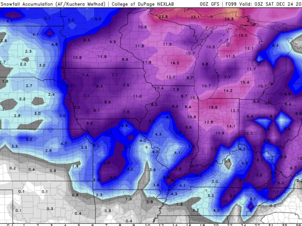
-
Pre-Christmas (Dec 21-23rd) Winter Storm
Harry Perry replied to Chicago Storm's topic in Lakes/Ohio Valley
-
Pre-Christmas (Dec 21-23rd) Winter Storm
Harry Perry replied to Chicago Storm's topic in Lakes/Ohio Valley
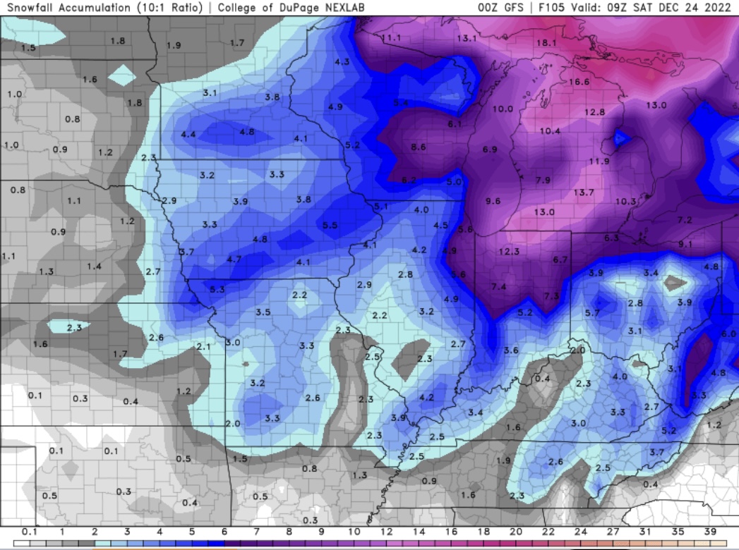
Definitely a wound up storm but getting weaker on QPF every run. -
Pre-Christmas (Dec 21-23rd) Winter Storm
Harry Perry replied to Chicago Storm's topic in Lakes/Ohio Valley
With storms of this magnitude, we’re going to see wild fluctuations 96+ hours out. You don’t want to be in the bullseye at the moment. One thing is pretty certain, it’s going to be a massive system. -
Pre-Christmas (Dec 21-23rd) Winter Storm
Harry Perry replied to Chicago Storm's topic in Lakes/Ohio Valley
Wagons west. -
2022 Short/Medium Range Severe Weather Discussion
Harry Perry replied to Chicago Storm's topic in Lakes/Ohio Valley
Really need to get some instability over here.. still socked in with thick low-level clouds. 14z HRRR out to lunch on current convection. 15z has it but doesn’t look to handle it all. -
Didn’t rain here last night, but with strong southerly flow the modified air has settled in here. Dew points were briefly in the upper 50’s this morning, but have only slightly increased to 63° imby at the moment with a stern 15-20mph southerly wind. 18z guidance not handling the surface moisture at all. Plumes all showing 70-74° surface dpoints at the current hour. SB instability obviously not materializing as expected across southern lower Michigan so that’s probably why the slight makes that turn SE, betting that the strongest storms ride that gradient further south and most convection will weaken quickly this side of the lake tonight.
-
Had nothing to 45kft tops develop overhead and drop about 10-15 close CG’s.. moved south now we’re getting no rain, but a constant loud rumble and lots of intracloud lightning. Didn’t expect that to materialize, wondering if more will develop and ride the gradient SE. Seeing some development mid lake at the moment.
-
2022 Short/Medium Range Severe Weather Discussion
Harry Perry replied to Chicago Storm's topic in Lakes/Ohio Valley
Same. Had one rumbler about a month ago. Outside of that, nothing. -
2022 Short/Medium Range Severe Weather Discussion
Harry Perry replied to Chicago Storm's topic in Lakes/Ohio Valley
Yes, thanks OHweather for the discussion and analysis. Great information. Will definitely be interesting to watch everything evolve tonight/tomorrow. -
2022 Short/Medium Range Severe Weather Discussion
Harry Perry replied to Chicago Storm's topic in Lakes/Ohio Valley
00z HRRR backed off on the squall threat locally. Shows one round of isolated storms around 8pm and another round firing up along the warm front riding southeast (training) around midnight. -
2022 Short/Medium Range Severe Weather Discussion
Harry Perry replied to Chicago Storm's topic in Lakes/Ohio Valley
This kinda smells of 5/29/2011.. nasty derecho followed by 90’s with no power. -
2022 Short/Medium Range Severe Weather Discussion
Harry Perry replied to Chicago Storm's topic in Lakes/Ohio Valley
Should make for an interesting afternoon.