Harry Perry
-
Posts
1,030 -
Joined
-
Last visited
Content Type
Profiles
Blogs
Forums
American Weather
Media Demo
Store
Gallery
Everything posted by Harry Perry
-

-
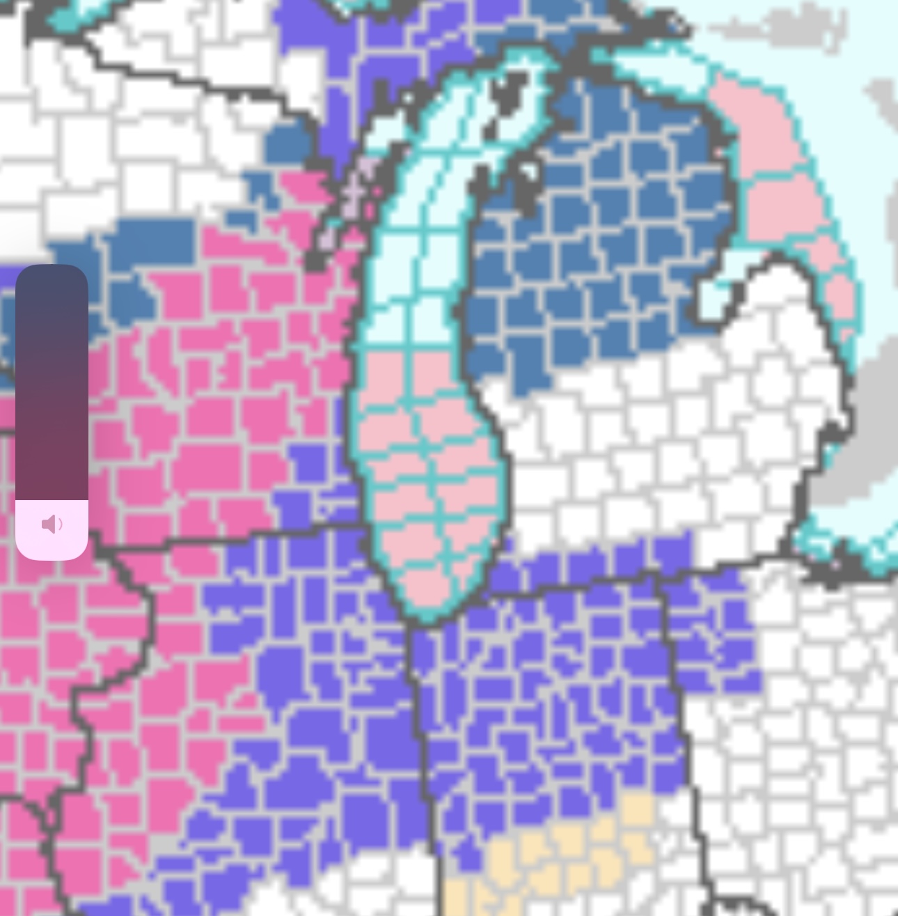
That map gives me flashbacks of a few days ago for today.
-
Excellent consistency. This solution screams mixing/dry-slotting issues for pretty much all the areas that got shafted today as well. Will be sampled tomorrow, should give us a better picture on what’s going to transpire, LOTS of moving pieces with this. One thing for certain, GRR will issue an advisory regardless of the outcome.
-
Kinda has that look to it honestly.
-
Similar to today, but a little closer/better than 10:1
-

Winter '23-'24 Piss and Moan/Banter Thread
Harry Perry replied to IWXwx's topic in Lakes/Ohio Valley
Ironically enough mine just set off the “low sensor battery” about an hour ago as well. -
I agree, end of the week looks impressive for us. My point was - in typical GRR fashion, we will be last to jump on the bandwagon for headlines until the event is damn near underway or nearly over - for the first appreciable snowfall of the season.
-
Already am. Old trends die hard.

-
Makes sense considering the spread. Chances of an outlier verifying are relatively low.
-
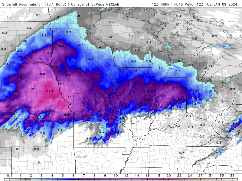
Anyone notice the 12z HRRR? Maybe I’m late to the game but… final image of the run 12z Tuesday. 980 with lowering heights directly east. Moving nearly ENE through central Missouri into south central Illinois.
-
Kind of a crapshoot around these parts. Hoping later in the week brings something a little more noteworthy. Will be fun to watch the evolution of this storm though.
-
-
This storm is nothing but high hopes and dreams. Head over to - Winter 2023/24 Medium/Long Range Discussion and check the storm out after…
-
We’re still 4/5 days out. Too early to be throwing any solution out yet.
-
We are still SO far out - no one should have any expectations yet. It is nice to finally have something to watch though, and to have weenie maps is pure lust.
-
Winter 2023/24 Medium/Long Range Discussion
Harry Perry replied to Chicago Storm's topic in Lakes/Ohio Valley
I could certainly see a redux of that storm being the outcome with this one if thermals are marginal.
-
Winter '23-'24 Piss and Moan/Banter Thread
Harry Perry replied to IWXwx's topic in Lakes/Ohio Valley
He emphasized on the potential being there for something big and that a lot is to change in the coming days, which I agree with. -
Winter '23-'24 Piss and Moan/Banter Thread
Harry Perry replied to IWXwx's topic in Lakes/Ohio Valley
I think you’ll be pleasantly surprised. -
Winter 2023/24 Medium/Long Range Discussion
Harry Perry replied to Chicago Storm's topic in Lakes/Ohio Valley
Spring started today if you ask him. -
Winter 2023/24 Medium/Long Range Discussion
Harry Perry replied to Chicago Storm's topic in Lakes/Ohio Valley

-
Beautiful day on this side of the lake, 76° and very low humidity. Some models showing dew points jumping 20°+ degrees here tomorrow in only 6-10 hours time. Will be interesting to feel.
-
Steady rain, constant rumbling, occasional lightning, 102° hot tub… love to see/feel/hear it. Weather station has a 27mph wind gust, felt like more but lasted less than 5 seconds. Thoughts and prayers for the people camping near Chicago.
-
Willing to bet we will have some good rumblers with anvil crawlers and stratiform rain around our areas tonight.
-
Looks like the HRRR sniffed out something, but looks like garbage over this way for tonight. Wonder what the next SPC outlook will look like. Almost looks as though storms are firing along the higher dew point gradient from N IL points southeast into Indiana. Dare I say… this mornings bullshit in Indiana forked SWMI once again by working over the atmosphere creating a rather large cold-pool, and only slowly advanced that cold-pool NE into the area while better untapped air pushed into northern Indiana? Time will tell. Already cooling off here @79° and clear skies.
-
I would believe that’s the cap breaking. Just the vents in my truck lol.