

Harry Perry
-
Posts
1,030 -
Joined
-
Last visited
Content Type
Profiles
Blogs
Forums
American Weather
Media Demo
Store
Gallery
Everything posted by Harry Perry
-
Intriguing setup around these parts later this evening. Will be interesting to see it unfold.
-

Mid-week potential of something somewhere
Harry Perry replied to Chicago Storm's topic in Lakes/Ohio Valley
Have about 2” here and only flurries at the moment. Had a decent band this morning and nothing really since.. but as usual this year - the heaviest snow was to come this afternoon - and poof. The models really had a hard time with this one lol. -
Mid-week potential of something somewhere
Harry Perry replied to Chicago Storm's topic in Lakes/Ohio Valley
Exactly 1” here as well. -
Mid-week potential of something somewhere
Harry Perry replied to Chicago Storm's topic in Lakes/Ohio Valley
Baby steps. -
Mid-week potential of something somewhere
Harry Perry replied to Chicago Storm's topic in Lakes/Ohio Valley
Have a feeling this will end up being a sloppy mess for nearly everyone involved (not everyone). Models struggling with track and amounts - that tells me that it’s going to be a low end - long duration event with many times where it isn’t snowing and instead is melting... wouldn’t hold fire to it. 2-4” looks solid around here with the majority falling between 9pm Tuesday night through about 1pm Wednesday. What. A. Mess. -
Mid-week potential of something somewhere
Harry Perry replied to Chicago Storm's topic in Lakes/Ohio Valley
For real -
Mid-week potential of something somewhere
Harry Perry replied to Chicago Storm's topic in Lakes/Ohio Valley
Bill Marino with GRR posted an update about an hour ago... the bleed continues. “I also adjusted the POP for Tuesday during the day. From the latest model runs I do not see much if any precipitation during the day time hours of Tuesday. It seems to this forecaster that the storm on Wed may be father to the east as it now seems the upper wave on the southern stream will take a little longer to phase with the northern stream wave. We will have to see how this plays out. I do not plan to change any headlines.” -
Mid-week potential of something somewhere
Harry Perry replied to Chicago Storm's topic in Lakes/Ohio Valley
Can’t believe how terribly the models have handled this system. 00z shall be interesting. -
Mid-week potential of something somewhere
Harry Perry replied to Chicago Storm's topic in Lakes/Ohio Valley
To my surprise GRR goes with a Winter Storm Watch... surely this will end up being a 2-4” incher (isolated 6” here and there) over the period of roughly 36 hours. Confidence = 60% of the time, it works every time. -
Mid-week potential of something somewhere
Harry Perry replied to Chicago Storm's topic in Lakes/Ohio Valley
“Are you reeling in the years (yeilds)” -
Mid-week potential of something somewhere
Harry Perry replied to Chicago Storm's topic in Lakes/Ohio Valley
Hey this isn’t necessarily a bad thing... -
Around an inch looking like a lock around here according to the uncle.. (Long duration inch at that).
-
My local office (GRR) throwing out operational guidance - saying high res is the way to go with this one. Not correctly handing the energy out west early on. edit: Nothing quite like a French tickler so close to Valentine’s Day lol
-
Oof.
-
Ended up with 3” of snow here... pouring sleet and freezing rain at the the moment. Light glaze on everything. 24°.
-
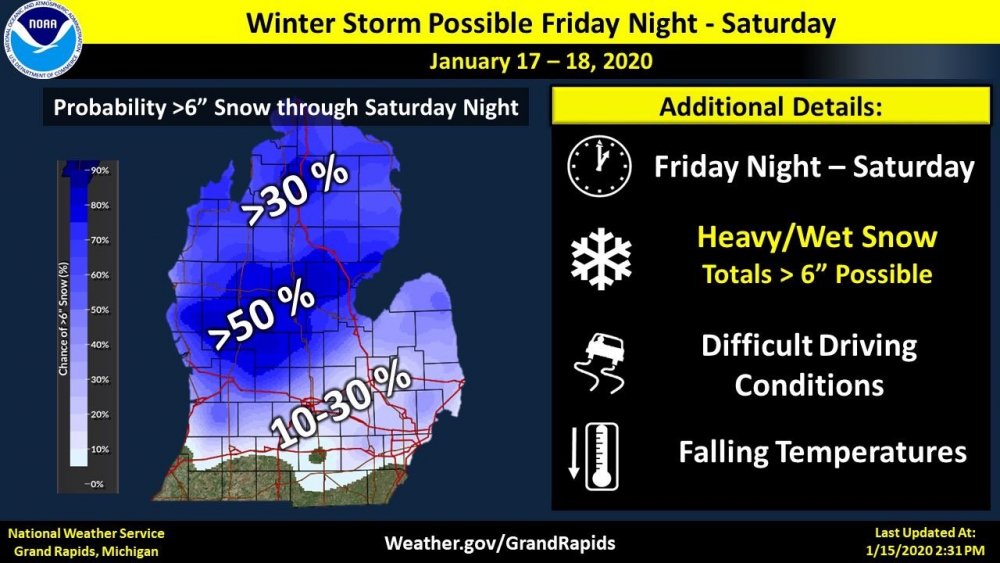
GRR staying with the advisory calling for a “general 4-8” with most of it falling by 10:00 am Saturday. General? More “significant” when it’s not common for the current season or last for that matter haha.
-
GRR saying “hold your horses.” .DISCUSSION...(Today through Next Thursday) Issued at 300 AM EST Fri Jan 17 2020 -- Wet and heavier snow to fall Friday night into Saturday for most of the area -- The area remains on track to see a impactful snowfall tonight and Saturday morning. With this in mind, we will be holding on to the Winter Weather Advisory as is for this forecast package. After a quiet day in which we just see clouds thicken up, and winds increase a bit, a fairly robust of snow is expected to move in after dark, and persist into Saturday. This snow will be the result of a very strong push of moisture coming in via a 70 knot low level jet nosing up into the area. The peak snowfall rates should come after 06z tonight and last until around, or just after 12z Saturday. We are looking at potential inch/hour snow rates of a more wet and heavy snow with lower snow-liquid ratios. This snow will obviously cause issues with the roads, and could cause some power outages as the snow could weigh down power lines and snap tree limbs. The snow should then let up in intensity on Saturday, and will likely even change to a wintry mix, and then rain/drizzle for areas along and south of I-96. This happens for a couple of reasons. The first reason is the surface low will come up into the area, and bring a brief shot of warmer air. This will come in aloft first, and could bring a brief bout of some freezing rain. This should not be a problem for roads falling on top of snow. Also, the deeper moisture will peel away, and could end up as some drizzle as the dgz becomes unsaturated.
-
Hilarity ensues as we get closer to the event, the plumes that we’re once all tight-knit around 5” are now all over the place (from less than an inch to 12”).
-
I thought the same. My bet is they change their tone a bit with a different forecaster by the mid-morning/afternoon forecast package. 3-5” seems like a lock, but they should definitely stress 6” or more locally is possible IMO, especially since this will be the biggest snowfall since November.
-
I agree.. just an odd graphic. Almost like they are trying to keep it cool in lieu of the last system.
-
I see my local office is getting ready to let the public down again haha. Hard to believe that graphic isn’t from a previous system - because I see no models showing what they’re predicting.
-
I can smell the bust from here haha. Seems like the qpf is overdone.. like several have mentioned the majority of the snow falling would be WAA snow - not saying 6-7” couldn’t fall from that, but I’d at least slice those numbers in half, especially around here with the slop that will likely mix in. Travelers advisory incoming.
-
January 10th-12th Winter Storm Potential
Harry Perry replied to Thundersnow12's topic in Lakes/Ohio Valley
Ended up with a glaze of ice and a dusting of snow here. -
January 10th-12th Winter Storm Potential
Harry Perry replied to Thundersnow12's topic in Lakes/Ohio Valley
Ice pellets and light rain here... been sitting at 32°/33° for the last hour. -
January 10th-12th Winter Storm Potential
Harry Perry replied to Thundersnow12's topic in Lakes/Ohio Valley
It’s not saying much... personally a half to third of an inch of ice would be considered major but who am I? the biggest thing I’m noticing is temps are over-performing around here (55° on my thermometer). Latest guidance shows us at 33° here with rain for most of the day tomorrow. (Unfortunately this goes against ALL local Mets if it becomes true). Lansing ends up around 31-32° with heavy rain by about 18z.. problem is - latent heat, sun angle, time of day and warm temperatures tonight - all put a damper on what was expected to be a major event. GRR’s latest thinking is taking the ice all the way to GRR (where temps will be ~30° by 12z tomorrow.) That is roughly a 40-60 mile jump west than previously forecast, but I feel due to the lack of forecast models showing current temps aoa 50° at the current hour, we know what the outcome is shaping up to be for the area.


