Harry Perry
-
Posts
1,030 -
Joined
-
Last visited
Content Type
Profiles
Blogs
Forums
American Weather
Media Demo
Store
Gallery
Everything posted by Harry Perry
-
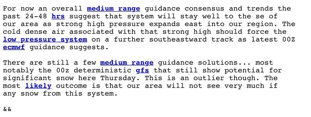
Well at least we’ve got the RAP and HRRR
-
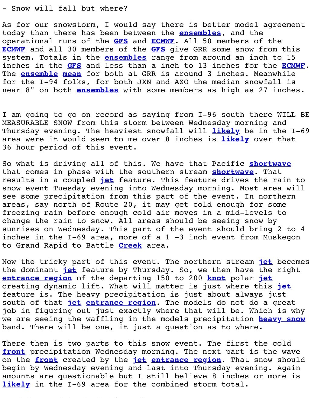
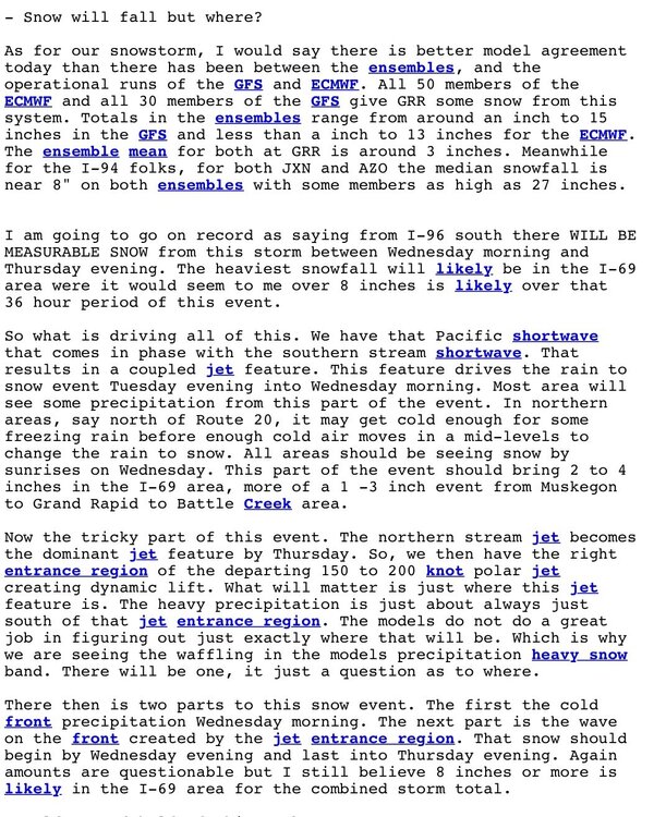
That’s probably the best way to look at it honestly. Most of our snow would come from Tuesday night - Wednesday and very little if anything more after that. Looking at some of 12z operational guidance SLP/Radar make this look like more of a one day storm.
-
Man! What a change between 00z and 12z GFS. Some places went from 0” to 17.5” in southern Indiana. 50-75 mile jumps to keep us on the edge.
-
I would imagine that is going to happen eventually.. totals are more inline at 10:1 while everyone keeps posting Kuchera ratios. How much will they come down is the question. Willing to bet someone will end up with a foot (maybe a little more) out of this before all is said and done.
-
I will say one of our better forecasters WDM (Bill Marino) wrote an excellent forecast discussion this afternoon regarding the upcoming system(s).
-
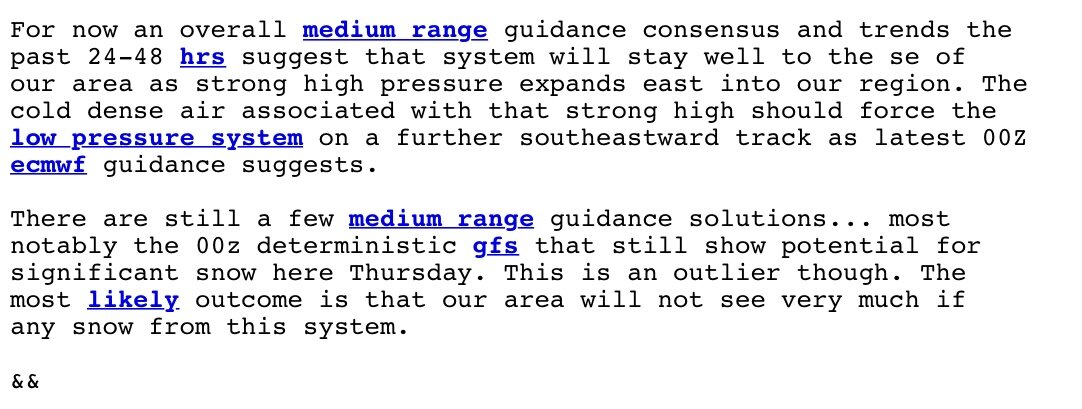
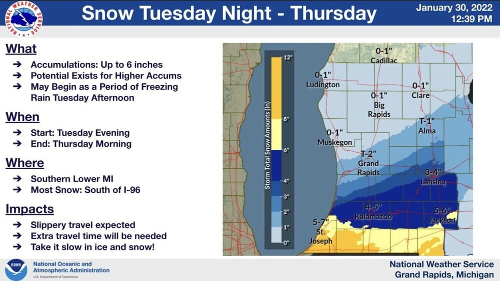
GRR “Little to no snow expected”. Interesting orientation of the heaviest snow axis…
-
GRR completely throwing the storm away that affects 75% of the CWA 72 hours out.. might not end up with an advisory at all, just 6-10” of snow haha. Even the EURO they’re riding to the grave shows appreciable snows across 50% of their CWA so their statement in this mornings AFD just shows how erroneous certain forecasters can be if it doesn’t affect their backyard.
-
Well said. Even if current forecast amounts were slashed in half it would still be a significant snow/ice for someone within the forum.
-
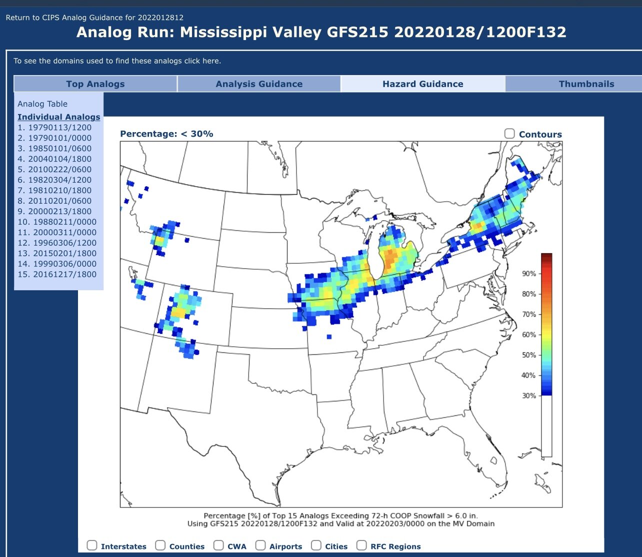
Suspect that GRR will issue an advisory for 8-12” for most around here … Looking at the CIPS analogs, 15 top matches. A few pretty good ones too.

-
Science.. we don’t care about that.
-
Looks like a pretty solid 4-6 incher around here, might end up with some isolated 7-8” in some spots but a very nice snow to welcome in the new year. SREF plumes trending upward with a mean just shy of 6” with a few over 8”.
-
After reading GRR’s AFD this morning, I couldn’t help but chuckle. They must lurk in these forums… - Snow still expected Saturday afternoon through Sunday morning - We are in the time frame (beyond 24 hrs from the event) where a watch issuance would be expected if it was warranted. At this time it does not seem warranted based on the latest guidance. Advisory and Warning decisions are typically made in the 12 to 30 hour time frame and we are moving into that zone today. We will likely make headline decisions (warnings or advisories) later today. Given the onset of snow is in the afternoon on Saturday we will likely make the headline decisions this afternoon. So, no headlines will be issued on this shift. Upstream offices are sticking with their watches, so even upstream where precipitation begins earlier they are sticking with the current headlines. Bottom line is we think this continues to look like a solid advisory for much of our area and potentially high end advisory over portions of the south half of our forecast area. If we are expecting advisories, which we are, watches are not warranted.
-
This is about the time the 00z model suite comes in with weenie amounts, just to trickle back down to reality just before the event begins. One can wish.. right?
-
It gets old. Many times in years past, model output would show 6-8” sometimes even as much as 10” inches of snow within a 24 hour period. Never a watch issued, only an advisory within 6-10 hours of the snow beginning. Snow starts, gets heavy… causes severe disruption in travel/commerce… GRR decides to upgrade select counties to a warning as the snow is ending.. that’s right ENDING. Has happened nearly every time. One time it never happened, just ended up with 7” of snow in about 10 hours with only an advisory. Really makes me scratch my head. I don’t get it. Seems the days of a Winter Storm Watch 24-48 hours out turning to a warning 12-24 hours out are long gone around here, and citizen’s always state “i didn’t know we were going to get this much snow!”, “Its terrible out there, who forecasted this?” right in the middle of the event. Coming from a safety standpoint, it’s unacceptable. Warn the public. “Roll the maps”.
-
Outlier.
-
Same!
-
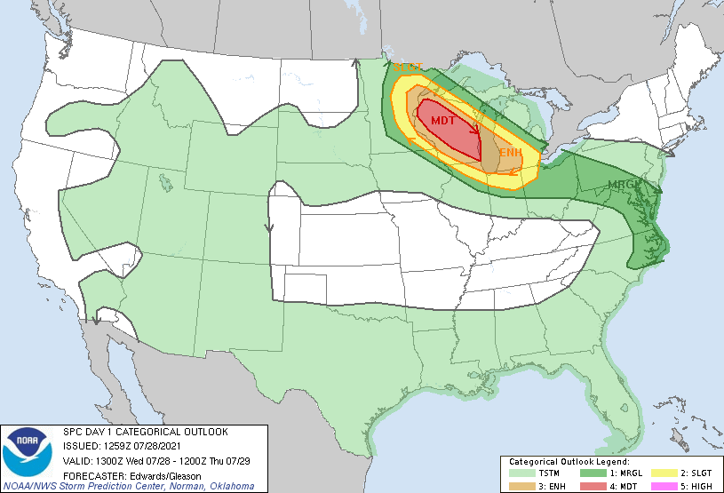
Not really the matter of “if” but more of a “where and when”. One of the more dynamic systems I have seen in recent years (3 jet cores over the area at the same time not to mention up to 70kts of shear)... rather impressive. Looks like the derecho will follow the instability gradient NW to SE with a slight curve (following the warm front) into south central Michigan late tonight/early tomorrow. Anyone between Eau Claire and Kenosha needs to be vigilant this evening. Looking like a once in every 5-10 year event in the making. Also gotta watch this low pressure meander across the area late tonight too - could add a local tornado threat from Chicago east to the SBN/KZO/GRR area.
-

Spring/Summer 2021 Banter/Complaint Thread
Harry Perry replied to madwx's topic in Lakes/Ohio Valley
Hopefully the sun will actually come out at some point this weekend/week/month. -
Yeah, this is for the birds. 5th straight day of garbage. Does not feel like the second week of July. Upper level low after upper level low.
-
June 20th, 2021 Severe Weather Event
Harry Perry replied to HillsdaleMIWeather's topic in Lakes/Ohio Valley
Models looked a lot better for this 12 hours ago. Looks more unorganized/isolated in regards to severe. Have lots of dense fog in the area that has to manage to burn off before mid/high level clouds from lasts nights MCV moves in. Don’t know how we’re going to make it to 89° today under cloudy skies. I would expect isolated supercells initiating around 5-6pm along or south of I-94. Best threat looks to come south of the MI/IN/OH border. Couple of latest HRRR runs show a nice bow blowing through that way. If we can somehow manage to get some better instability then obviously the threat would be greater. -
Looks like our only hope for rain the next couple of weeks is afternoon daytime heating type of showers/storms. Definitely feast or famine. We really need a good overnight soaker - say a pseudo stationary front with multiple rounds of convection aided by a strong LLJ. One can hope that happens at some point soon to really help our growing season this year.
-
Should be alright for the most part.
-
This didn’t age well lol. Latter half of the upcoming week looks borderline heatwave-ish. Dew points pushing 70 with daily highs near 90. Dew points might be a a little overdone for some with how dry the ground is.
-
Seeing lots of roller coasters incoming for the first half of the month. Polar jet makes a return about once a week through the middle of the month before finally staying north of most of us (according to long range GFS guidance). Surely will change a million times between then and now. Seems like we could squeeze a storm or two out in such pattern... unless the fronts are coming through at 9-10 in the morning like usual lol.
-
I don’t think so either, hopefully there’ll be lack of persistent upper level lows and troughing in the GL regions/east. Seems like it’s been western ridge and eastern trough since 2011.