

Harry Perry
-
Posts
1,040 -
Joined
-
Last visited
Content Type
Profiles
Blogs
Forums
American Weather
Media Demo
Store
Gallery
Everything posted by Harry Perry
-
Love to see it.
-

4/2-4/3 Potential Major Severe WX Outbreak
Harry Perry replied to Geoboy645's topic in Lakes/Ohio Valley
Warm front is just not going to make it up here. Looks to stay south of the border now. Couldn’t have been the diarrhetic rain we had for 12 hours straight. It just wouldn’t stop. Pretty ominous looking for the Ft. Wayne region though. -
4/2-4/3 Potential Major Severe WX Outbreak
Harry Perry replied to Geoboy645's topic in Lakes/Ohio Valley
Lots of clearing beginning to break out. Warm front surging northward. Up 8° in the last hour. Wish it were 10am though. -
4/2-4/3 Potential Major Severe WX Outbreak
Harry Perry replied to Geoboy645's topic in Lakes/Ohio Valley
Impressive gradient, nearly 30° temp. difference along the warm front.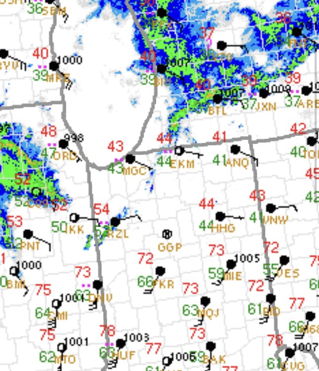
-
4/2-4/3 Potential Major Severe WX Outbreak
Harry Perry replied to Geoboy645's topic in Lakes/Ohio Valley
This. Just going to be too little too late most likely, but hodographs look nasty from you to Detroit and south this evening. The ONLY thing we are missing is surface cape. Looks like we might squeeze 4-500 j/kg but probably not enough, if a storm does go up though, it could be a doozy. SPC will probably hang onto the ENH up here for that reasoning. Edit* ENH adjusted south of the state lines. -
4/2-4/3 Potential Major Severe WX Outbreak
Harry Perry replied to Geoboy645's topic in Lakes/Ohio Valley
Most likely yes for both of us. We might get a local threat but nothing widespread by the looks of things. -
4/2-4/3 Potential Major Severe WX Outbreak
Harry Perry replied to Geoboy645's topic in Lakes/Ohio Valley
Really not thinking there’s a chance in my neck of the woods. Regenerating showers overhead just north of the front is going to keep it from pushing far enough north before the next round in Illinois is here. Not saying it can’t happen, but atmospheric recovery is pretty much out of the cards in Michigan. South of the borders should be interesting though. -
Back to western ridge and eastern trough for a while though. Looking ahead will be good though when the jet buckles, plenty of cold air to the north and subtropical air from the Gulf. Ultimately I believe this will be a pretty significant severe weather season for the midwest and into the Great Lakes region - similar to 2011/12 with lots of above average temps mixed in.
-
I’m willing to bet the dust is helping create the lightning without a doubt.
-
2025 Short Range Severe Weather Discussion
Harry Perry replied to Chicago Storm's topic in Lakes/Ohio Valley
HRRR has a bit more moisture to work with. Looks less cluttered and more defined. This one could creep up on us if a little more moisture is realized. -
Fall/Winter '24 Banter and Complaints Go Here
Harry Perry replied to IWXwx's topic in Lakes/Ohio Valley
I remember that! Would have to change it to channel 9 (used to be our local weather radar channel with noaa weather radio playing in the background) to see what was coming lol. I believe that carried on into the 90’s for a while. I remember the screen red with scrolling text from the NWS on tornado warnings and I think severe thunderstorm warnings as well. -
Fall/Winter '24 Banter and Complaints Go Here
Harry Perry replied to IWXwx's topic in Lakes/Ohio Valley
There is a site dedicated to the old style (90’s) Weather Channel local on the 8’s. Weather Star 4000 I believe. Click the link, put in your zip and enjoy the 90’s anytime you want. https://weatherstar.netbymatt.com I want to say I remember there was a latter version from the early to mid 2000’s that did the same but can’t find it. -
Fall/Winter '24 Banter and Complaints Go Here
Harry Perry replied to IWXwx's topic in Lakes/Ohio Valley
Man, you just awoken the inner 10 year old in me. The big snowflake vs. two little ones from the 90’s. Then later on, early 2000’s, the 3/4 row of snowflakes for heavy snow. The dual lightning bolts for “strong” storms… How times have changed. The good ole days. -
Winter 2024-25 Medium/Long Range Discussion
Harry Perry replied to michsnowfreak's topic in Lakes/Ohio Valley
This is no time for romance. -
I see there was a video posted this morning, pretty surreal to see. Pilot (or officer) waiting for that Delta flight to land was also taking a video of it, likely because of the intense crosswind and complete whiteout on the ground. I think Fox had it on Facebook. Nothing short of a miracle that they all managed to ultimately walk away, from a crash AND fireball. Pretty wild.
-
Winter 2024-25 Medium/Long Range Discussion
Harry Perry replied to michsnowfreak's topic in Lakes/Ohio Valley
Really “squaring in” on the suck zone for this winter. -
Tomato or tomato. Convective blocking downstream played part in moisture transport issues further north which ultimately changed the way the trough was evolving. Not saying your wrong, just saying it wasn’t just a janky h5 evolution.
-
Very true and how most of us should look at it. Atleast we all have some snow on the ground, finally. And like Powerball said, we’re just stuck in the crappy couple year period… it’ll all come full circle. .
-
About the same here.
-
Truly one of the most difficult storms systems to forecast in recent memory. And the models? Pfft…. All risk, no reward.

-

-
To be fair, the hostility is acceptable given the circumstances. Two (three?) storm systems with northern/southern stream energy in the neighborhood, all within a week… before more suppression, and it all went to hell at the last minute to boot. Plenty to be irritated about, but what can you do.
-
As well as the 18z RGEM.
-
I was just thinking about this as well. We’re getting old.
-
I believe it has some effect as to why the models are struggling with the cold sector precipitation.


