fountainguy97
-
Posts
1,112 -
Joined
-
Last visited
Content Type
Profiles
Blogs
Forums
American Weather
Media Demo
Store
Gallery
Everything posted by fountainguy97
-

January 15th-17th 2024 Arctic Blast/Snow Event
fountainguy97 replied to John1122's topic in Tennessee Valley
That would do it lol. This will be a breath of fresh air considering ground will be fully frozen at the start. We won't lose a single flake to melt assuming CMC is over doing it. Not to mention we won't break 32 for an entire 7 days. Even 2-3" of snow will stick around for days -
January 15th-17th 2024 Arctic Blast/Snow Event
fountainguy97 replied to John1122's topic in Tennessee Valley
What's absurd is the entire state is pretty much below 32 starting this Sunday and going through the next Sunday. And most of that is WAY below 32 -
January 15th-17th 2024 Arctic Blast/Snow Event
fountainguy97 replied to John1122's topic in Tennessee Valley
I feel like the gfs was about the best case. Seems any more amped it'll be easy to have mixing issues. I don't see a way to get a ton more moisture out of this. -
January 15th-17th 2024 Arctic Blast/Snow Event
fountainguy97 replied to John1122's topic in Tennessee Valley
This is a super long event. Snow breaking out with the Arctic front by hr 90 on gfs but trailing piece doesn't pull away until hour 144 -
January 15th-17th 2024 Arctic Blast/Snow Event
fountainguy97 replied to John1122's topic in Tennessee Valley
Wow that was a major East coast Storm there. 12z will be interesting! Need it to turn that corner even faster to get precip back our way but that's a great look 5-6 days out. i feel like we have been saying 6 days out for 4 days now lol. -
January 15th-17th 2024 Arctic Blast/Snow Event
fountainguy97 replied to John1122's topic in Tennessee Valley
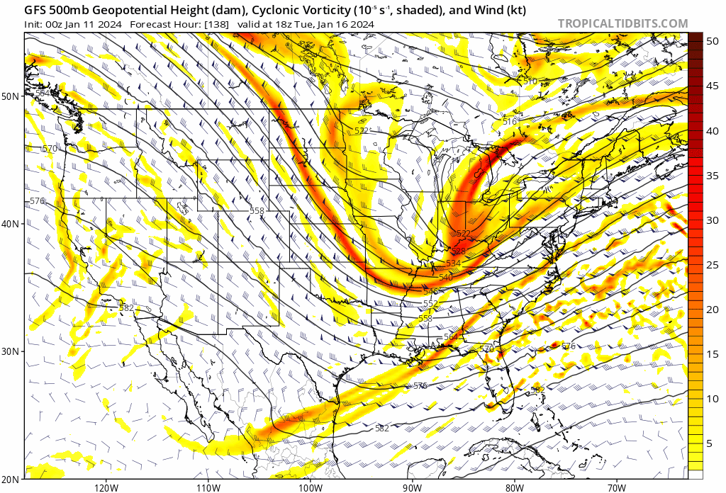
GFS trending toward EURO. All I care about right now is what the euro does. If we can just increase QPF even .15-.2 across the region you're talking about widespread 7-8" the ceiling is so high with this one. GFS is snow in the single digits. Ratios will be upwards of 20:1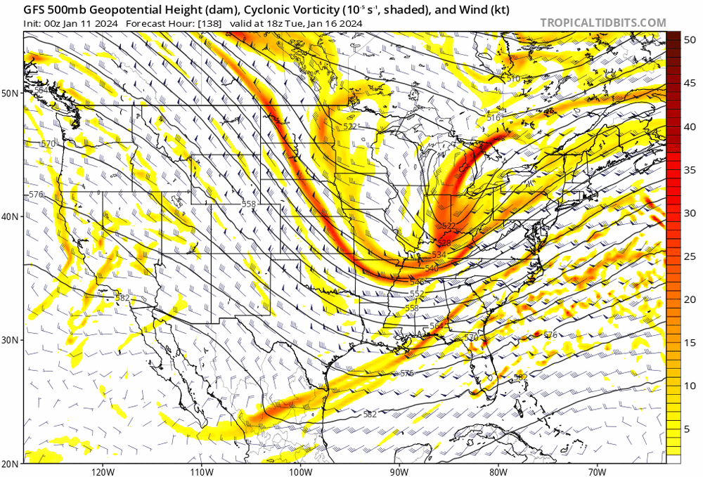
-
January Medium-Long Range Discussion
fountainguy97 replied to Holston_River_Rambler's topic in Tennessee Valley
Moved to storm thread. -
January Medium-Long Range Discussion
fountainguy97 replied to Holston_River_Rambler's topic in Tennessee Valley
Models have definitely come together for an overall idea. Trends will still happen from here. Euro still the best for snow which makes you pretty confident. Remember we are tracking .1's of qpf 5-6 days out. The euro has the best coastal development yet but it still doesn't throw much qpf back across ETN. It doesn't really consolidate the energy but just strings it out. -
Fall/Winter Banter - Football, Basketball, Snowball?
fountainguy97 replied to John1122's topic in Tennessee Valley
I'm just angry right now lol. Nico has a MUCH higher ceiling than Milton ever did. We should be competing at a high level again next season. 12 team playoff actually makes post season interesting. -
Fall/Winter Banter - Football, Basketball, Snowball?
fountainguy97 replied to John1122's topic in Tennessee Valley
Truthfully I'd rather TN just be irrelevant. Both in football and basketball losing every game that matters. SMH let's just suck again to not waste my time. -
January Medium-Long Range Discussion
fountainguy97 replied to Holston_River_Rambler's topic in Tennessee Valley
Yes that 18z run was probably about to bury someone -
January Medium-Long Range Discussion
fountainguy97 replied to Holston_River_Rambler's topic in Tennessee Valley
Yeah this run won't do anything for us but a major trend toward euro with holding back the energy. Euro leading the way. -
January Medium-Long Range Discussion
fountainguy97 replied to Holston_River_Rambler's topic in Tennessee Valley
18z gfs defitnely a big shift toward EURO with more focus on holding back that piece. Initial frontal stuff dies out. -
January Medium-Long Range Discussion
fountainguy97 replied to Holston_River_Rambler's topic in Tennessee Valley
Thats a good summary. Models seem to be trending more toward the holding back solution but I hope we don't end up in an awkward inbetween solution where the front is dead and the back energy is too late -
January Medium-Long Range Discussion
fountainguy97 replied to Holston_River_Rambler's topic in Tennessee Valley
But that's the question. Does this just flatten into a non-event? Verbatim euro is basically a swing and a miss for the SE with a late blooming surface low. I guess the ceiling is much higher with this look but it'll be easy for this to be too late for most of the E US besides New England. -
January Medium-Long Range Discussion
fountainguy97 replied to Holston_River_Rambler's topic in Tennessee Valley
-
January Medium-Long Range Discussion
fountainguy97 replied to Holston_River_Rambler's topic in Tennessee Valley
"I swear bro. The NAM has this one nailed. Trust me" someone start the thread. My last one went poof haha -
January Medium-Long Range Discussion
fountainguy97 replied to Holston_River_Rambler's topic in Tennessee Valley
Yes I believe that's a suitable outcome for all of TN. Middle/west gets the frontal aspect and then the lingered shortwaves backfill the front as a low pops for the east. it's not worth much the but 12z NAM is in line with the euro of a slower and more solidified "backend" shortwave (I guess that's how we will call it) -
Winter 23-24' Wx Observations Thread
fountainguy97 replied to Carvers Gap's topic in Tennessee Valley
The winter of dustings continues today. I've had 6 snowfalls. 3 Trace and 3 dustings. The frustrating thing is almost every snow looked better and then fizzled short range. I've spent so much time at 33-35 and snow this winter. -
January Medium-Long Range Discussion
fountainguy97 replied to Holston_River_Rambler's topic in Tennessee Valley
Yeah need that backing into the cold boundary from a developing coastal. Probably need a thread for 12z. Mid-west TN basically a lock for some frozen -
January Medium-Long Range Discussion
fountainguy97 replied to Holston_River_Rambler's topic in Tennessee Valley
For people East of the Plateau you want the EURO to keep trended for a negative tilt. The only way we score is if we get a low to form and fire convection. If not then yes. The moisture will go poof. the good news is the gfs is ticking that way but still not enough. That's the only way this brings much of anything to Eastern areas. Need this to continue. We don't need an 1" of precip with this. Its so cold just need a few hours of good rates. -
January Medium-Long Range Discussion
fountainguy97 replied to Holston_River_Rambler's topic in Tennessee Valley
This one feels feast or famine. It's either a major event or it's clear skies. Our energy is still over 4 days from being onshore and we have another system to deal with this week too. Still just warning shots but a good sign is that we have cross model support. I personally don't like the looks of this one especially for ETN. But really for anyone. This is one of those storms that will be a pain in the rear to track. It'll be easier to squash this into the ocean vs amp IMO. I hope I'm wrong we have lost most support for an amped version with most of 12z a whiff besides EURO. In normal circumstances I would argue that's right where we want it (for middle and west regions). I'm taking the sit back and relax approach. Let's see what we have come Friday when it's only 2 days from being onshore. -
January Medium-Long Range Discussion
fountainguy97 replied to Holston_River_Rambler's topic in Tennessee Valley
Yeah gfs is coming toward euro which is our miller A. Gefs is very suppressed as is EPS. Thats a good sign that maybe the OPs are on the northern end of guidance. It's possible that means we won't see a massive north trend. Just speculation at this point. we have 2 major systems (1 ongoing 1 to come) before this one is next up to bat. Long way to go but it is probably the best look of the season so far. -
January Medium-Long Range Discussion
fountainguy97 replied to Holston_River_Rambler's topic in Tennessee Valley
This has been my reservation for this system. This screams cold rain for E TN. But the other portions of the state are due! -
January Medium-Long Range Discussion
fountainguy97 replied to Holston_River_Rambler's topic in Tennessee Valley
NAM'd