fountainguy97
-
Posts
1,112 -
Joined
-
Last visited
Content Type
Profiles
Blogs
Forums
American Weather
Media Demo
Store
Gallery
Everything posted by fountainguy97
-

January 15th-17th 2024 Arctic Blast/Snow Event
fountainguy97 replied to John1122's topic in Tennessee Valley
Don't do this to us hrrr.
-
January 15th-17th 2024 Arctic Blast/Snow Event
fountainguy97 replied to John1122's topic in Tennessee Valley
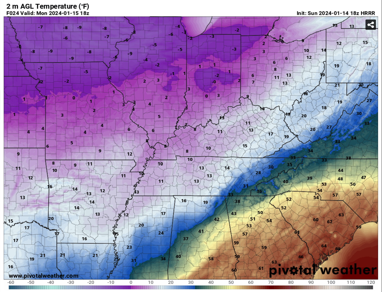
Very steady NW trend continuing on HRRR at 20z. Chattanooga is now above 32 by 9am tmrw and border counties of NE TN. this is just... bad.
-
January 15th-17th 2024 Arctic Blast/Snow Event
fountainguy97 replied to John1122's topic in Tennessee Valley
Here is the 12z hrrr vs the 19z hrrr. Notice the freezing line southern extent steadily trending north. Are we being reverse NAM'd in the East? Haha hate to say it but trends are not your friend in ETN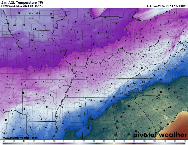
-
January 15th-17th 2024 Arctic Blast/Snow Event
fountainguy97 replied to John1122's topic in Tennessee Valley
I think it's pulling that up from the south and piling it against the apps. A completely reasonable scenario IF it's as amped as it shows. The cold push really isn't doing much "pushing" it's pretty stagnant for the ETN area. Not to mention peak heating. -
January 15th-17th 2024 Arctic Blast/Snow Event
fountainguy97 replied to John1122's topic in Tennessee Valley
It sure is consistent isn't it? This last minute amped trend is no bueno for the valley east. I'm not too surprised but it's not fun to watch haha. Absolutely rocks Middle TN though!! -
January 15th-17th 2024 Arctic Blast/Snow Event
fountainguy97 replied to John1122's topic in Tennessee Valley
Bright banding is always indicative of a phase change in the precipitation. It may not show on the ptype charts but the hrrr is mixing sleet/rain in for 3-5 hrs. It's not convection banding it's brighter returns hitting larger objects ie sleet/rain
-
January 15th-17th 2024 Arctic Blast/Snow Event
fountainguy97 replied to John1122's topic in Tennessee Valley
Lots of mixing on hrrr for eastern counties. To be expected at this point. the faster onset is probably not helping the cold push.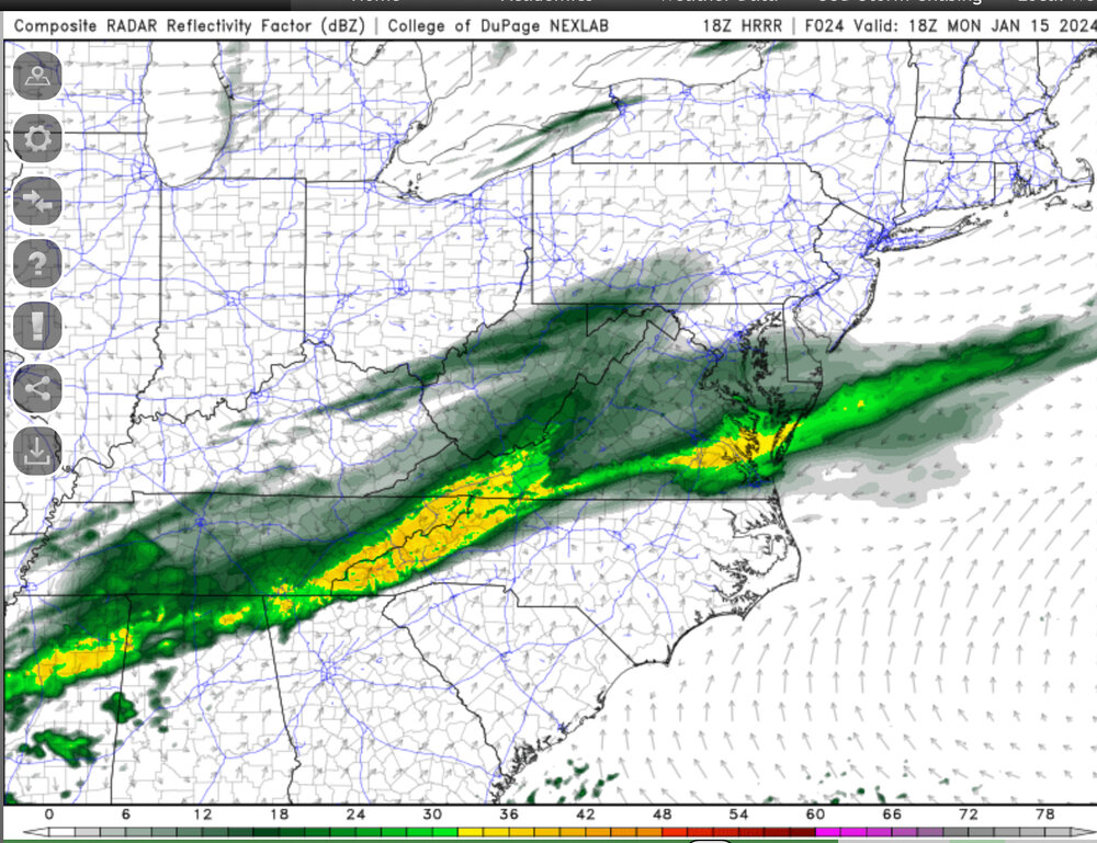
-
January 15th-17th 2024 Arctic Blast/Snow Event
fountainguy97 replied to John1122's topic in Tennessee Valley
Hrrr is trending toward that little bend in the precip shield that was not kind to Eastern areas on other models. -
January 15th-17th 2024 Arctic Blast/Snow Event
fountainguy97 replied to John1122's topic in Tennessee Valley
Yes part of the mixing you see is lack of moisture. It's a very valid concern still though. i have doubted the Ptype maps before and said "but soundings support snow!" You know what I ended up with? Not snow lol. -
January 15th-17th 2024 Arctic Blast/Snow Event
fountainguy97 replied to John1122's topic in Tennessee Valley
It is a valid concern. I'm in the same boat here 5 miles from the NC/TN border. The hrrr is ticking north in the mid range now. I would expect mixing for you and myself Monday during peak heating atleast. -
January 15th-17th 2024 Arctic Blast/Snow Event
fountainguy97 replied to John1122's topic in Tennessee Valley
Probably large enough event to make an OBS thread -
January 15th-17th 2024 Arctic Blast/Snow Event
fountainguy97 replied to John1122's topic in Tennessee Valley
If it catches on we will take 50/50 credit haha! -
January 15th-17th 2024 Arctic Blast/Snow Event
fountainguy97 replied to John1122's topic in Tennessee Valley
Rufus!! -
January 15th-17th 2024 Arctic Blast/Snow Event
fountainguy97 replied to John1122's topic in Tennessee Valley
finally, the RGEM caves and almost all eastern areas remain frozen. -
January 15th-17th 2024 Arctic Blast/Snow Event
fountainguy97 replied to John1122's topic in Tennessee Valley
Speak for yourself. No mercy over here it's bullseye in my backyard or this is the largest bust of all time. seriously though the reason I'm here and not elsewhere is because no one here lets their backyard determine if a model is good or bad. Can't be said for others. -
January 15th-17th 2024 Arctic Blast/Snow Event
fountainguy97 replied to John1122's topic in Tennessee Valley
Little bit more warm nose for me. I'll probably Mix for 3-6 hrs but hopefully you guys stay all snow! -
January 15th-17th 2024 Arctic Blast/Snow Event
fountainguy97 replied to John1122's topic in Tennessee Valley
The RAP is just absurd. All frozen! (does anyone else find it annoying you have to screenshot pivotal on mobile??)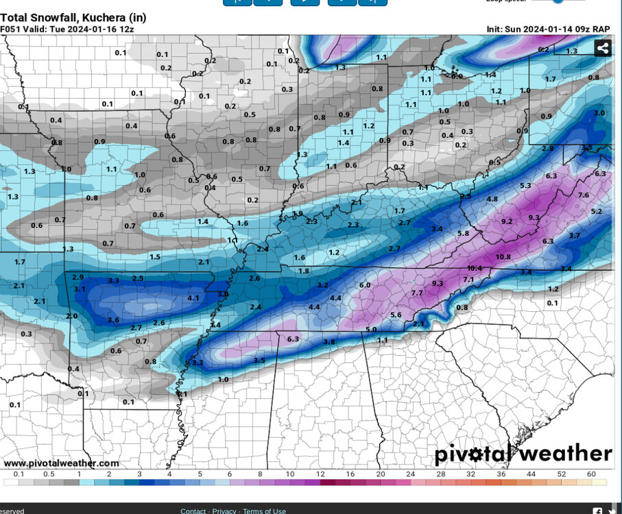
-
January 15th-17th 2024 Arctic Blast/Snow Event
fountainguy97 replied to John1122's topic in Tennessee Valley
I noticed that as well. I do find it hard to believe the RGEM scours out the cold. I go from 21 to 36 on the RGEM Monday with snow falling. Doesn't add up. -
January 15th-17th 2024 Arctic Blast/Snow Event
fountainguy97 replied to John1122's topic in Tennessee Valley
Yep! RGEM pushing in more cold. One more tick at 12z and I'm happy haha hrrr and RGEM absolutely crush eastern portions while NAM nearly blanks the same locations.. -
January 15th-17th 2024 Arctic Blast/Snow Event
fountainguy97 replied to John1122's topic in Tennessee Valley
Yeah 12km is a minor tick better for eastern areas but still a massive difference between hrrr and NAM. Inside 24 hrs now... -
January 15th-17th 2024 Arctic Blast/Snow Event
fountainguy97 replied to John1122's topic in Tennessee Valley
Still snowing on hrrr too lol it's razor thin but keeps me frozen the entire event. NAM looks good too! A tick south. Update: better early on. Nasty warm nose still later. -
January Medium-Long Range Discussion
fountainguy97 replied to Holston_River_Rambler's topic in Tennessee Valley
the GEFS is super aggressive on the 5 day threat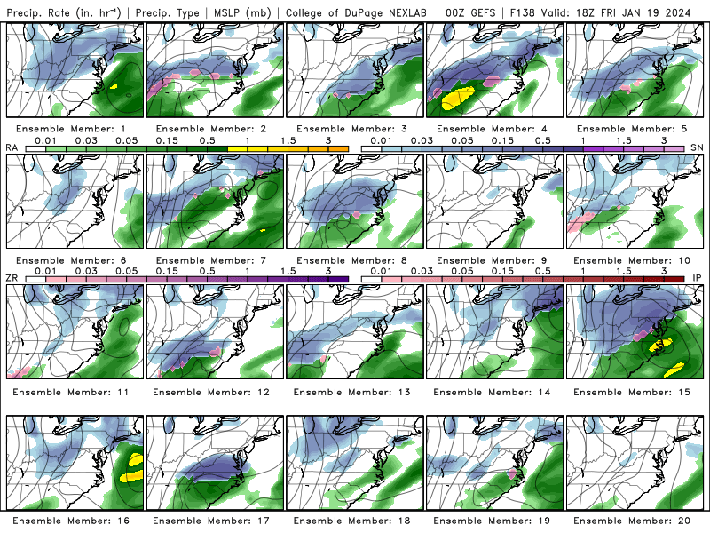
-
January 15th-17th 2024 Arctic Blast/Snow Event
fountainguy97 replied to John1122's topic in Tennessee Valley
Man I feel much more optimistic for extreme eastern areas such as myself after 00z. Pretty much all high res keep temps below 32 to the border except the NAM (which jumped SE in a big way) and the RGEM. Hopefully the RGEM can get on board with more cold push by 12z! -
January 15th-17th 2024 Arctic Blast/Snow Event
fountainguy97 replied to John1122's topic in Tennessee Valley
I agree. Let's get that cold push all the way to the border and I'll be happy -
January 15th-17th 2024 Arctic Blast/Snow Event
fountainguy97 replied to John1122's topic in Tennessee Valley
FWIW the WRF family of models and the fv3, and the RAP, are like the hrrr with the cold push all the way to the state line