fountainguy97
-
Posts
1,267 -
Joined
-
Last visited
About fountainguy97

- Birthday 06/14/1997
Recent Profile Visitors


-
27 with steady snow this afternoon. Working toward dusting currently. It was 65 yesterday..
-
woah. Outlier for sure but that's a money shot.
-

Jan 30th-February 1st 2026 Arctic Blast/ULL Snow OBS Thread.
fountainguy97 replied to John1122's topic in Tennessee Valley
End total for me was 12" and got down to -1. Overall an incredible event which was by far my largest snow in the 7 years I've been here. -
Jan 30th-February 1st 2026 Arctic Blast/ULL Snow OBS Thread.
fountainguy97 replied to John1122's topic in Tennessee Valley
14.4. 8" on the dot. Rates have been lackluster most of the day. I assume I need some NW winds to get some mountain terrain involved. -
Jan 30th-February 1st 2026 Arctic Blast/ULL Snow OBS Thread.
fountainguy97 replied to John1122's topic in Tennessee Valley
They have been by 3-4 times salting my road this morning. Each time it turns slushy for 15 min then straight back white. I think they are just building up a skating rink at this point. -
Jan 30th-February 1st 2026 Arctic Blast/ULL Snow OBS Thread.
fountainguy97 replied to John1122's topic in Tennessee Valley
Really starting to stack up now. Probably 7" or more. Temp is 14.7. Probably another 4-6 easily on the way. -
Jan 30th-February 1st 2026 Arctic Blast/ULL Snow OBS Thread.
fountainguy97 replied to John1122's topic in Tennessee Valley
18.9. Got several hours of sleep during the slower rates. I'd guess 5" out there. Still snowing pretty well. -
Jan 30th-February 1st 2026 Arctic Blast/ULL Snow OBS Thread.
fountainguy97 replied to John1122's topic in Tennessee Valley
26.5 here and down to a heavy glitter falling. The flow has shifted and should enhance southern areas for the next few hours. When the pivot begins moisture will back up against the mountains again. I'd guess 3" here, yard has that bumpy look right before it smooths out. -
Jan 30th-February 1st 2026 Arctic Blast/ULL Snow OBS Thread.
fountainguy97 replied to John1122's topic in Tennessee Valley
Should backfill over next couple of hours. -
Jan 30th-February 1st 2026 Arctic Blast/ULL Snow OBS Thread.
fountainguy97 replied to John1122's topic in Tennessee Valley
27.3. It's changing to that smaller higher ratio stuff. Very high number of flakes falling. -
Jan 30th-February 1st 2026 Arctic Blast/ULL Snow OBS Thread.
fountainguy97 replied to John1122's topic in Tennessee Valley
Wow. Just like that. Not a flake to big nickels pouring out of the sky. 30.5 -
1-30/2-1-26 Arctic Blast, ULL Snow Event
fountainguy97 replied to John1122's topic in Tennessee Valley
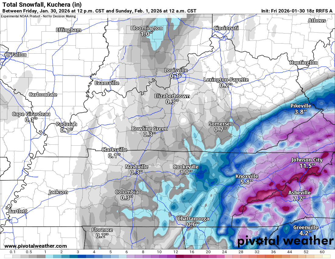
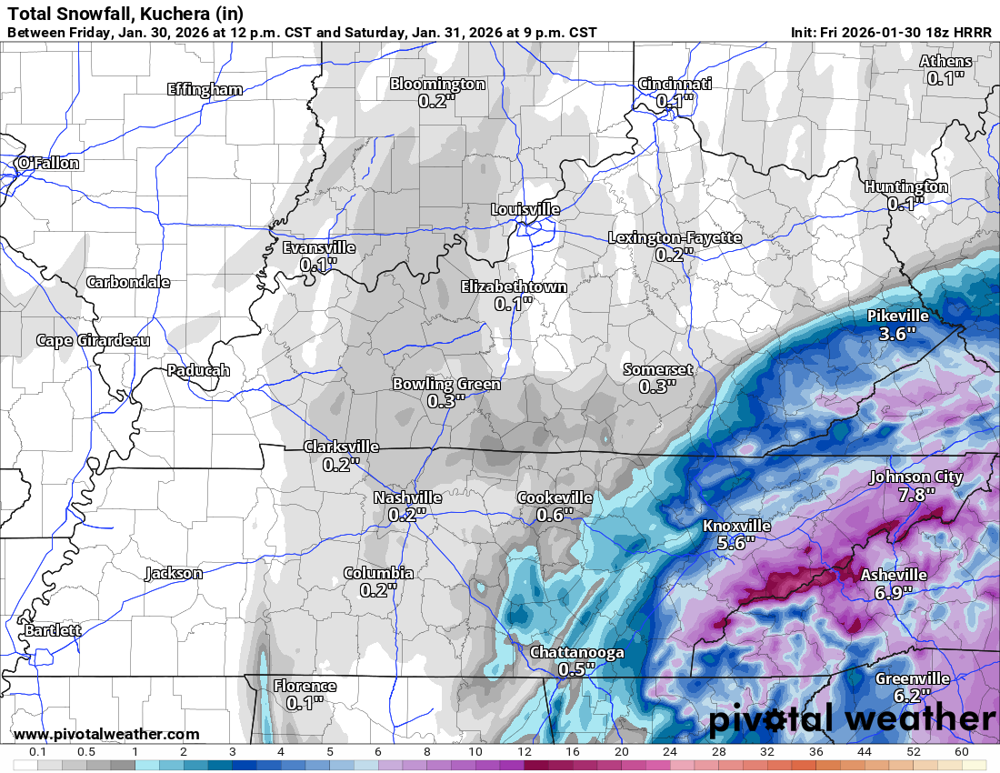
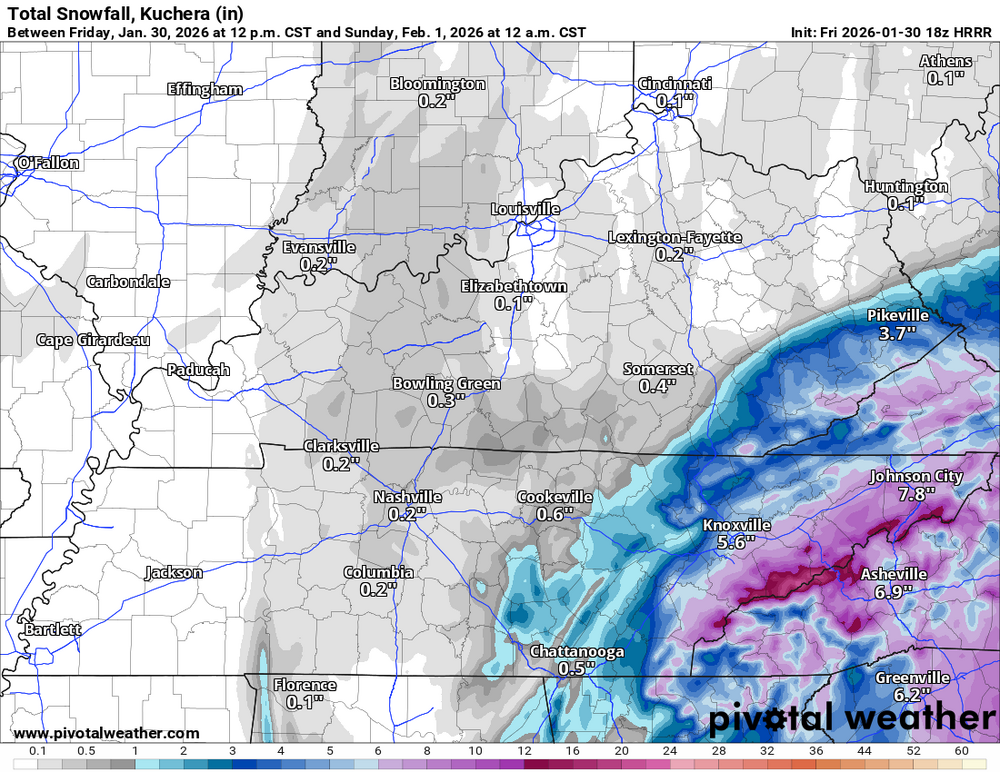
The big 3 RRFS HRRR 3km nam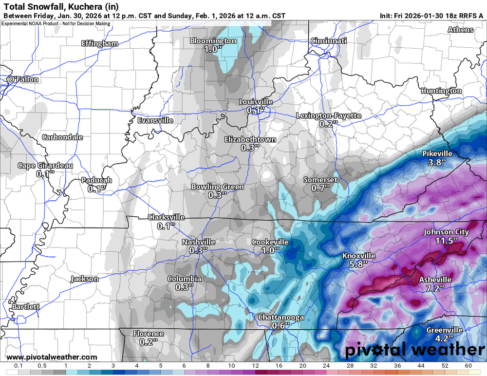
- 782 replies
-
- 4
-

-
- extreme cold
- snow
- (and 1 more)
-
1-30/2-1-26 Arctic Blast, ULL Snow Event
fountainguy97 replied to John1122's topic in Tennessee Valley
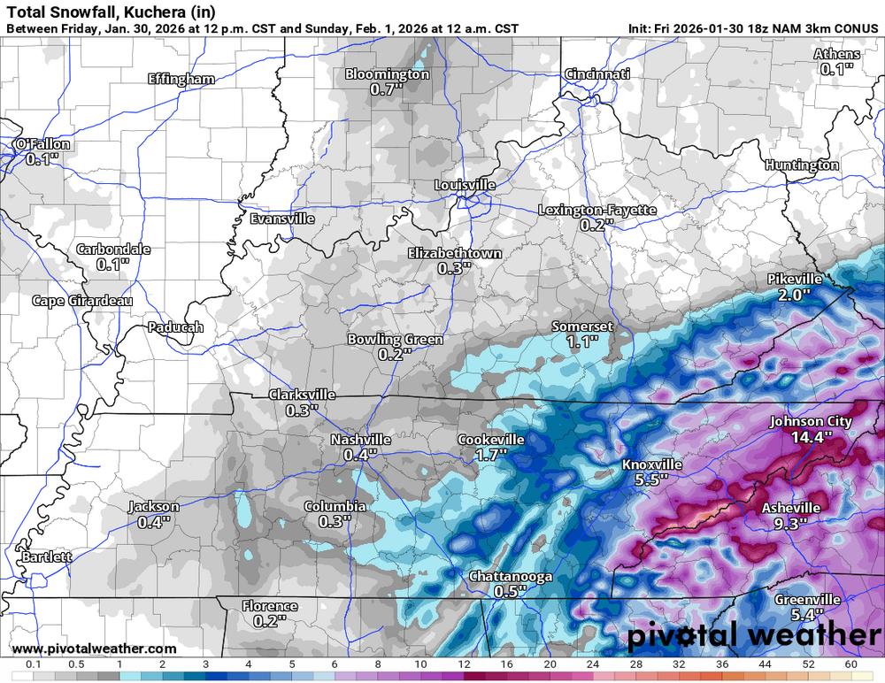
wow these 18z models are hitting hard. Johnson city over 15" on 3km NAM -
1-30/2-1-26 Arctic Blast, ULL Snow Event
fountainguy97 replied to John1122's topic in Tennessee Valley
yep when that ULL forcing arrives it'll be hours of .5 hour rates all night into the day tomorrow.- 782 replies
-
- 2
-
-
- extreme cold
- snow
- (and 1 more)
-
1-30/2-1-26 Arctic Blast, ULL Snow Event
fountainguy97 replied to John1122's topic in Tennessee Valley
This thing hasn't even started yet. Latest HRRR lays it DOWN across ETN tonight. Temps crashing from 20s down into the teens with a deform band just rocking. Accumulations don't start until 6-9pm. That's always been the case. at least the last few model runs
- 782 replies
-
- 3
-
-
- extreme cold
- snow
- (and 1 more)