Kevin Reilly
-
Posts
2,935 -
Joined
-
Last visited
Content Type
Profiles
Blogs
Forums
American Weather
Media Demo
Store
Gallery
Everything posted by Kevin Reilly
-
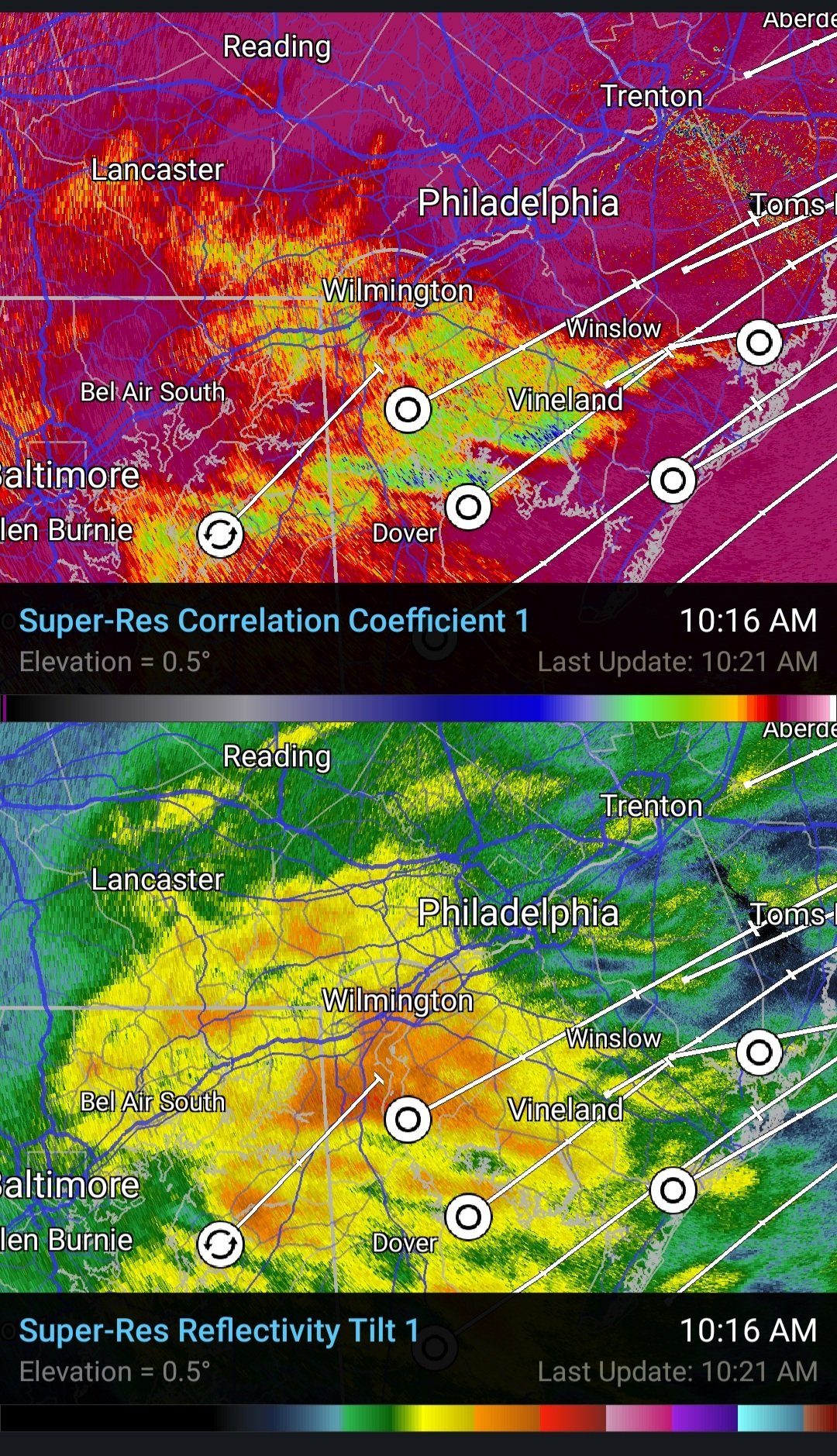
Looks like second wave is further east if you look at the radar it just missed good thing too because it would have likely all been freezing rain. It's bad enough with the freezing drizzle all night. We have crept up to 28 here with a dew point of 27. It is an absolute skating rink here in Media. Even my driveway where I threw down a generous supply of salt is very icy.
-
Looks like a nasty little icing event for SE PA on the GFS. I mean right here in Media it never stopped we have light freezing rain everything is encased at 27 degrees.
-
A couple of observations from Media. 27 very very fine light pixie dust flakes still guess freezing drizzle but there is a light white frosting on the cars were I cleared off. Is that ocean effect snow moving NE to SW across New Jersey from the north central coast down through Burlington County. The radar is starting to show our next wave down south of Washington towards Knoxville TN. See where that goes. See to our south winds have switched around to the NE again.
-
Media 27 pixe dust flakes fine light slivers of snow frosting the cars white total snow and ice here 5.6” or so snow sleet beat down on paved 3.5”
-
Media 26 sleet freezing rain sun trying to plow through the clouds.
-
Media Delaware County we went up to 25 we have a 70% sleet 30% pure liquid now so freezing rain zero flakes what the hey hey!! Rain drops splashing against the windows freezing on contact immediately.
-
True True definitely some big differences due to colder temps with ratios banding and sleet issues all combined to cause wild fluctuations in snow depth location to location down to the mile lol
-
Media Delco heavy sleet 24 lost all the flakes sleet chunks ripping holes into the snow pack 5” about
-
Well here in Media it’s coming in as snow 95% snow 5% sleet 24 degrees umm wow guy in Wilmington is right Heavy Snow in Media Delaware County must be overcoming the thin warm layer with the heaviest rates.
-
About to get demolished by that band coming up from the south in Media Delaware County wish I knew of its snow or sleet when it gets here.
-
See forum south reporting snow mixing in now so column even down there is cooling. I’m watching that area coming up 95 from Baltimore should be here soon looks fun!
-
You do see what’s coming up from Baltimore and SW of Washington?
-
Crazy Media is 3.1” you are only like 2 miles away lol we have snow sleet mixing in at times lots of mangled flakes.
-
Media Delaware County 50/50 mix of snow and sleet 24 2.8”
-
Media Delaware County Partly Cloudy where it is clear its crystal clear! 25 dew point 6
-
Absolutely will change from a Watch to a Winter Storm warning probably for 4-8" in lower SE PA with some sleet and freezing rain too to be thrown in to cover the uncertainty of the warm layer at 5000 to 7000 feet.
-
Let's stop the hedging and just get right to it here. Areas along I-95 if no warm layer at 5,000 to 7,000 feet 6-9" if there is a warm layer we are looking at 3-4" with a flip to sleet 1-2" of that possibly followed by 0.10-0.20" of freezing rain depending on the warming aloft. I would at this point lean more towards a 50/50 mix of all the models and go with the 3-5"+ idea. So. We are almost at the point of letting it play out. Obviously less south and east into coastal New Jersey and south in Delaware.
-
Bingo!! Love your analysis!! So the only conclusion I can draw is the slow bleed of warmth off the Atlantic warm waters further out transport west bound then slowly north bound.
-

Feb Long Range Discussion (Day 3 and beyond) - MERGED
Kevin Reilly replied to WinterWxLuvr's topic in Mid Atlantic
You forgot the light rain at the end sun coming out and a rainbow true at least in Delaware County. -
totally agree I see. I see the same thing down this way then in relation to elevation where the Airport 95 Corridor see nothing but go up into NW Delaware County points north and west you see more. I am not expecting many problems at all down this way into Central Delaware County.
-
However remember cold air in these situations gets trapped in the valleys. The lower you are the worst the ice will be, but you also have to be further north into where the cold air is hanging on.
-
I don’t know I’m having a hard time buying all liquid no frozen Monday into Tuesday I bet things trend SE starting tonight. That storm sliding down the west coast is taking the long way to get here and with below zero air to our west it will be interesting to see if the cold air sloshes east as the storm down south moves east. Guess the key is that SE ridge popping in reaction to the cold air diving South through Texas. Does the jet make a right hand turn east zonal cutting the warm air off from riding north?? I’m interested to see how this plays out. Guess I’m going on cold air is heavier and denser than warm air theory and we aren’t just going to scour out surface cold do fast. I mean it’s 25 here now and our high was supposed to be 30 temps fell all days with light rain.
-
There is no chance of that however the driveway sidewalk is now an ice skating rink 25 here light rain
-
Just out here in Media some areas of the driveway ice skating rink other parts just wet so think but it’s continuing to freeze 26 here with light rain.
-
I think so my driveway is getting icy last hour I’m 3.3 miles north of Wallingford