Kevin Reilly
-
Posts
2,935 -
Joined
-
Last visited
Content Type
Profiles
Blogs
Forums
American Weather
Media Demo
Store
Gallery
Everything posted by Kevin Reilly
-
 Hmm if only this were winter this would be quite the norlun trough
- 216 replies
-
- 1
-

-
- hurricane
- tropical storm
- (and 2 more)
-
That looks like it’s heading on off to the northwest guess that’s the reason for the flood watch today and tonight into tomorrow

-
We take! Lol https://www.tropicaltidbits.com/analysis/models/?model=hrrr®ion=us&pkg=mslp_pcpn_frzn&runtime=2021082100&fh=0
- 216 replies
-
- 3
-
-
- hurricane
- tropical storm
- (and 2 more)
-
Looks like some west-southwesterly shear now attacking Henri it’s beginning to feel the trough not sure if the shear from the west is temporary.
-
Looks like some west-southwesterly shear now attacking Henri it’s beginning to feel the trough.
-
Looks pretty clear the difference is the western models like the icon HMON Ukie and some Nam members are picking up the upper air low capture and the GFS misses the upper air low capture because it’s too far east. wonder if the models are latching onto the correct circulation with Henri think the low level and the mid level circulations still are not alighned and are still separate for now causing tracking problems.
- 216 replies
-
- 1
-

-
- hurricane
- tropical storm
- (and 2 more)
-
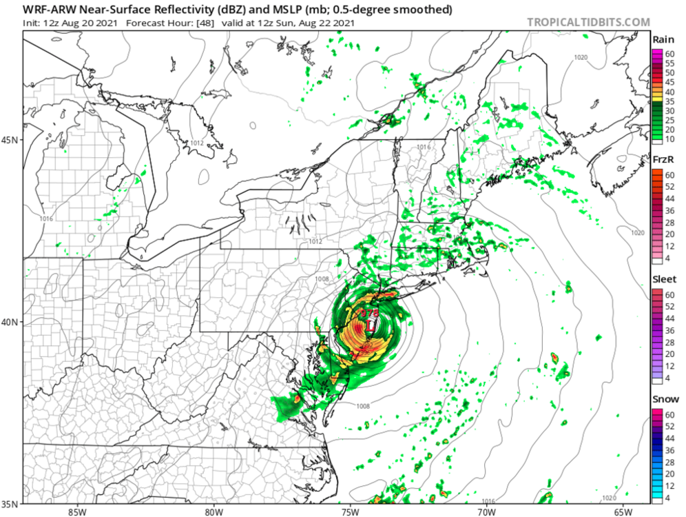
So scorecard: Icon and ARW and are a left hook into NJ and affect our area while the NAM and GFS are 350 miles further ENE makes total sense now.
-
Umm yea wow that’s a problem lol guess we shouldn’t let our guard down
-
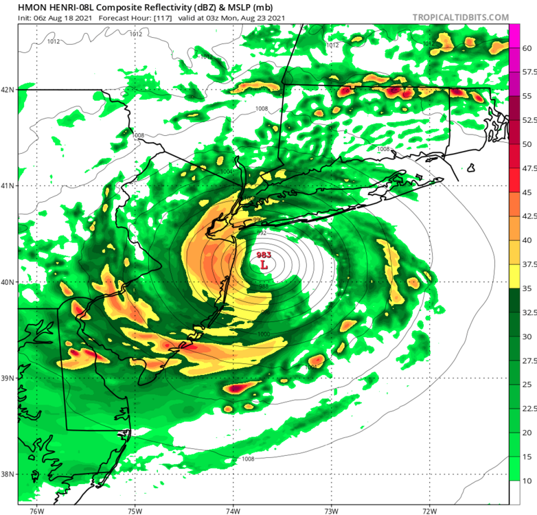
Currently at 995 mb so too weak
-
Pretty far west I’m sitting at 75 west here in Media Delaware County Pennsylvania 13 miles wsw of Philadelphia.
-
It’s just not that simple yes ridge to the east and trough to the west but there’s an upper level low setting up in the Mid Atlantic states that could have implications on the final track of Henri.
-
I’d be concerned about the tug west of Henri there’s an upper air low down south of me in southern PA awful lot of rain poised to come in here right now from the southwest. That upper air low will tug Henri west to the coast making the left hand turn.
-
Looking at water vapor map Henri is getting into some very favorable conditions right now and is still moving west there is a trough approaching from the west towards the East Coast that should turn Henri north bound probably tomorrow but how far west can he get first will be interesting. Now also there is an upper level low diving SSW across the central Great Lakes that will be the feature that would or could hook Henri to the west. All the players are on the table now it is just a waiting and timing game. What is very clear from the Water Vapor map presentation is it is all systems go where Henri is right now and he is clearly strengthening.
-
I am in Philadelphia forum but the water temp at ACY Atlantic City is 79 degrees and 83 in and around Cape May and Delaware bay thanks to persistent south and southeast winds due to Fred passing by to the east and the WAR building west over the past few days.
-
And what would that be?
-
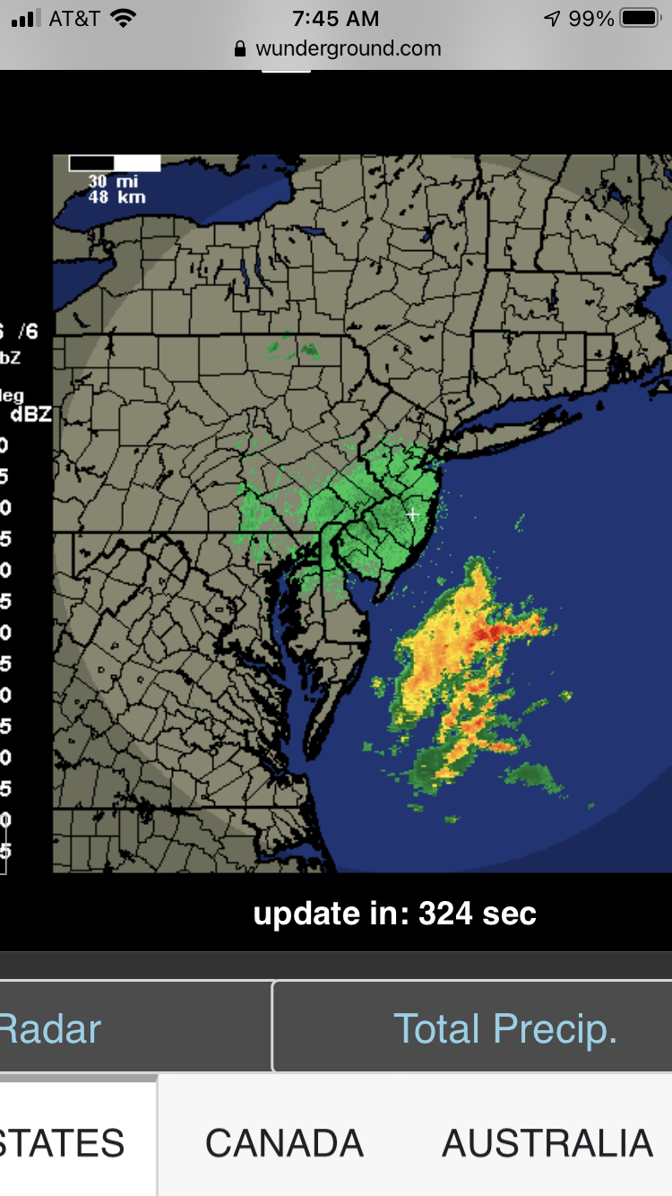
Here in Media Delaware County picked up 0.44" overnight. we have 1.94" for the month of August so far. As of 10:50 pm while I was passing by Chester Creek was pretty high to about banks at Middletown Twp. Ridley Creek was at bank full at Media along Knowlton Road and Crum Creek was below bank full at Beatty Road in Springfield. All creeks were moving pretty swiftly and all brown.
-
So far in Media Delaware County today Partly Sunny a trace of rain last hour. High today was 90 highest wind gust 22 mph. Currently 84 dewpoint 74 breezy fast moving clouds moving due north.
-
That would be the Gulf Stream currently though the models do not show Henri getting that far west if so it would be a very close call for most of the East Coast Outer Banks to New England.
-
When do we start taking note of Henri trending further west with some runs. I mean 2 days ago this was 450+ miles out to sea. Now the HMON has the center 20-30 miles east of NJ with bands getting as far west as Eastern Pennsylvania.

-
Looks like that came a smidge west too
-
Yikes 970 mb wow this is still 4.5 to 5 days out too that’s an eternity in the tropics when it comes to track and intensity. A troubling item also that’s there is no strong front trough coming to the East coast actually the WAR builds west on this run.
-
Henri will be very interesting to track the East Coast is pretty open without a strong trough coming in from the west. There is a pretty good blocking area of high pressure off of the New England Coast for days and that would appear to be a key to where Henri goes. Pretty much a east southeasterly flow pointing up along the East Coast this week into the weekend. It's interesting I do remember a few GFS runs last week showing this system making a run to the Carolina coast then blocked up the coast last week.
-
Quite impressive considering where we were just 24 hours ago wow!! The only inhibiting factor to me is the dry air punching northeast in the southwest quadrant. All in all it does have a chance to become a minimal hurricane in the next two to three hours before it encroaches on land and feels the land effects.
-
GFS really strengthens Fred down to 983 mb at landfall that is pretty dramatic should be interesting to see what happens tomorrow.
-
Yep take a look at the water vapor map Gulf is and Atlantic open for business to our south the pipeline is lining up and heading Northeast with Fred embedded in the flow to boot too.