

Kevin Reilly
-
Posts
2,935 -
Joined
-
Last visited
Content Type
Profiles
Blogs
Forums
American Weather
Media Demo
Store
Gallery
Everything posted by Kevin Reilly
-

January 7th First Snow for some N&W folks Discussion
Kevin Reilly replied to ChescoWx's topic in Philadelphia Region
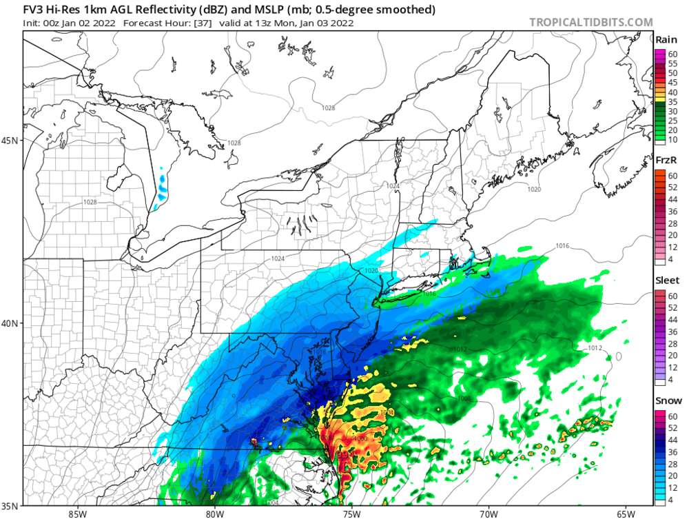
Also wonder if with that hole or near that hole there may be a bit of sleet or freezing drizzle. -
Well I do have 96% humidity up here in SE Pa so there is juice available behind the weak cold front today.
-
Truly humbling our snow total for the year is 0.4" I am very happy for the folks to the South and East looks like a solid 8-14" Looks like power issues in and around DC and Virginia.
-
Exact here in Media Delaware County we had a dusting 3 times and it evaporated away. All told it snowed lightly for about 45 minutes now. All we have for it is 0.1" that has come and gone 3 times so I guess 0.3"
-
Media Delaware County 29 humidity 74% dewpoint 22 flurries light snow trace amounts.
-
Media Delaware County 13 miles SW of Philadelphia International Airport 8 miles north of the Delaware border 36 dewpoint 27 amazing at 3:30 it was 61 with a dewpoint of 58 expecting 2-4” here in my opinion.
-
Media Delaware County 36 dewpoint 27 amazing at 3:30 it was 61 with a dewpoint of 58 expecting 2-4” here in my opinion.
-
Yea there was this one I think in 1988 where PHL had cirrus clouds and Wildwood got like 24" and snow drifts on the boardwalk think this was in the first 10 days of January too.
-
Talk about cut off wow
-
Toasty Atlantic warm layer off the ocean highly plausible water temps 46-48 across Delaware Bay
-
Wonder if this stuff now is playing havoc with models for early Monday system. We had that line rip through here at lightning speed too dropped a quick half inch of rain winds gusted to 30-35 out of the WNW in Media Delaware County.
-
-
Media Delaware County a few flakes for 3 minutes or so 36f dewpoint 24 currently cloudy.
-
Hmm check how warm overall the largest body of water is on Earth. The Pacific Rules all of the Lower 48 and there’s no end in sight. The Warm Gulf of Mexico and Atlantic aren’t helping either. This is our new normal with few exceptions over the past 10 years or so.
-
Finally, it's showing clippers riding the boundary across the area warm south and cold north battleground in between like the idea, but the reality is probably weak systems being shredded apart and moving too fast to really dump. Looks like a progressive WNW flow but it's better than a fast WSW flow making slow progress.
-
Wow amazing what a difference a year can make. I am astounded also by the first tornado ever recorded in Minnesota in December History yesterday too. This year so far is very different. I am wondering if these extreme weather events we are seeing in The PAC NW with all the flooding, the extreme tornado outbreak on Dec. 10th, the tornado outbreak yesterday, and the record high temperatures are a signal of a major change that will take place soon after the New Years or shortly after Christmas?? What I am thinking is maybe La Nina is peeking and we are watching the Pendulum swinging to another regime.
-
Really, I don't remember that at all. Well, we know that is not happening this December through Dec. 22nd anyways. I think we are waiting past New Year's this year for sure with the relatively warm zonal flow off the Pacific
-
Media, Delaware County Squall line here pretty much fizzled as it went through 8 minute downpour wind gusted to about 20-30 nothing out of the ordinary with the exception of warm 60's today.
-
A very light snow shower here in Media Delaware County 6:30-7:20 pm our second trace of the year. Yay get ready for 70 degrees and above normal temperatures next week.
-
I think that’s overdone wonder how much of that is sleet?
-
CMC trying to pull a rabbit out of the hat and the gfs minus will be predicting weather on Venus!
-
Don’t worry it’s sleet
-
First Flurries snow showers December 2nd first measurable snowfall December 25th this is for just north and west of I-95 Delaware County points north and west.
-
I would think if this were later December or January we would be enjoying a dynamic situation where the main storm was mainly wind and rain off the Atlantic followed by a quick dumping of snow for some last night with more of an inverted trough look. This morning would probably be more snow squalls.
-
Media Delaware County picked up 1.10” in 30 minutes a few flashes of lighting one was a strike fairly good boom of thunder followed by lightning streaking across the sky. Steady light rain still falling looks like a new storm developing with upper support right over the area.


