Kevin Reilly
-
Posts
2,935 -
Joined
-
Last visited
Content Type
Profiles
Blogs
Forums
American Weather
Media Demo
Store
Gallery
Everything posted by Kevin Reilly
-

E PA/NJ/DE Winter 2024/25 Obs/Discussion
Kevin Reilly replied to JTA66's topic in Philadelphia Region
I mean seriously everything right now is a total wait and see but models are nice to look at. The speed and movements of the pieces are going to change over the next 24-48 hours I believe especially once our power house storm leaves Sunday. Once again we are staring at an interesting storm coming in tomorrow to Sunday complete with snow to rain possibly thunderstorms for some followed by power outage 50 mph gusts Sunday into Monday, but yet we find ourselves looking beyond to what is coming in 4.5 days we have been doing this since the thunderstorm hail fest right before Christmas. I’m still in the camp a lot of things can go wrong with this set up the one I fear most is the guide stage right out to sea and or develop too late and bury New England time will tell. If 20” is still on the table come Monday night I’m really excited! -
Screams progressive flow knock it east regime which is plausible at this lead.
-
Shades of 1996 with this model showing this while Euro just moves on northeast.
-
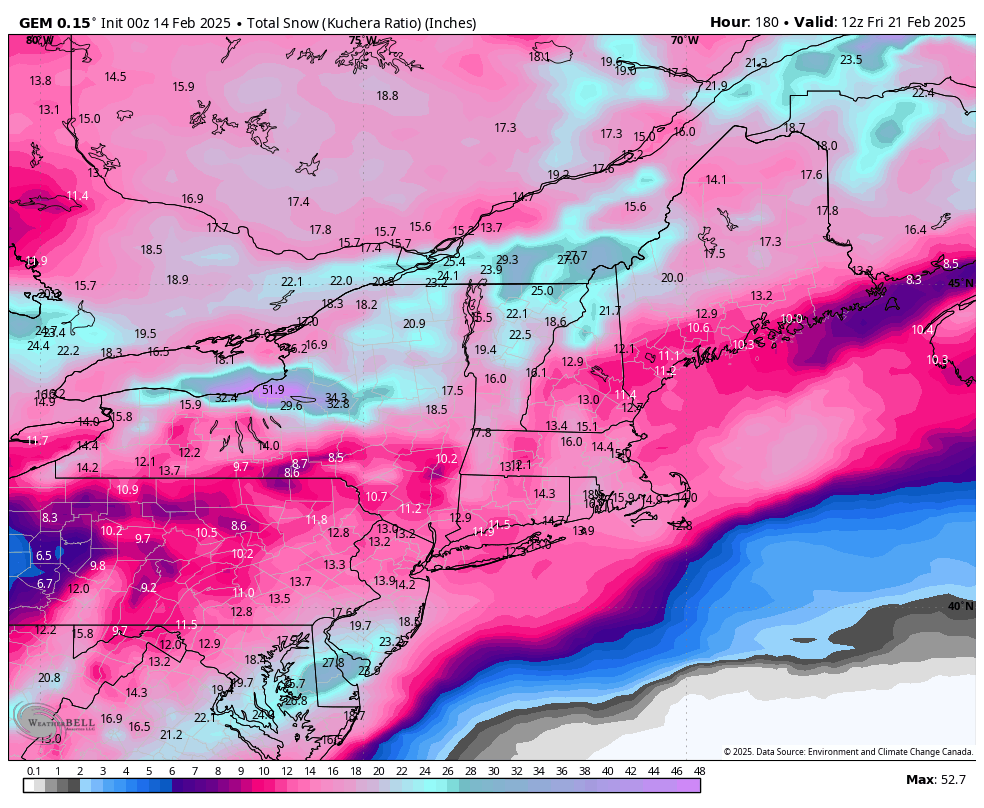
Holy Fook!!! FOLKS!!!
-
Gfs snowfall map looks very wonky in SE Pennsylvania I’ve never seen a solution like that toss!
-
Possible line of thunderstorms too!
-
E PA/NJ/DE Winter 2024/25 Obs/Discussion
Kevin Reilly replied to JTA66's topic in Philadelphia Region
In the what can go wrong department I can see the storm developing too late we get some snow 3-6” but the big winners is New England when they get 2-3 feet. -
E PA/NJ/DE Winter 2024/25 Obs/Discussion
Kevin Reilly replied to JTA66's topic in Philadelphia Region
We take but we know this is changing like 10 more times and probably is a southern New England crusher while we get 4-6” we can dream though!
-
E PA/NJ/DE Winter 2024/25 Obs/Discussion
Kevin Reilly replied to JTA66's topic in Philadelphia Region
I’ll take this sure!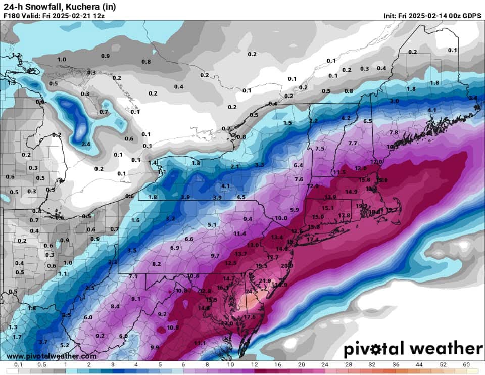
-
E PA/NJ/DE Winter 2024/25 Obs/Discussion
Kevin Reilly replied to JTA66's topic in Philadelphia Region
Boston 4 feet need to get the pretty maps! Decent trend. -
E PA/NJ/DE Winter 2024/25 Obs/Discussion
Kevin Reilly replied to JTA66's topic in Philadelphia Region
Power out trees down I guess. -
E PA/NJ/DE Winter 2024/25 Obs/Discussion
Kevin Reilly replied to JTA66's topic in Philadelphia Region
Yea winds gusting here to near 40 mph from the northwest right now temps falling 45 currently all snowpack gone!! However cold air advection well underway! -
Sleet probably skewing maybe especially southeast?
-
You know this has been happening a lot this year we are looking at beyond hour 145 just to have something knocking on the door that’s interesting either happening or about to happen in 48 hours. This has been happening since the December thunderstorms that dropped multiple episodes of hail.
-
E PA/NJ/DE Winter 2024/25 Obs/Discussion
Kevin Reilly replied to JTA66's topic in Philadelphia Region
Hmmm sleet -
E PA/NJ/DE Winter 2024/25 Obs/Discussion
Kevin Reilly replied to JTA66's topic in Philadelphia Region
Followed by this give me three of these to ease drought guy and me.
-
E PA/NJ/DE Winter 2024/25 Obs/Discussion
Kevin Reilly replied to JTA66's topic in Philadelphia Region
That would be a replay out of the winter of 2024-2025 play book honestly though this is totally normal February stuff and then being capped off with a big dog or 10” storm gets us to or above normal snowfall for the year it’s within reach. -
E PA/NJ/DE Winter 2024/25 Obs/Discussion
Kevin Reilly replied to JTA66's topic in Philadelphia Region
Temp on the way up here 32 to 33 it’s over here and all points north very soon. -
I can two years ago when we got 1.6" of snow for the entire winter.
-
E PA/NJ/DE Winter 2024/25 Obs/Discussion
Kevin Reilly replied to JTA66's topic in Philadelphia Region
32.9f humidity 99% humidity dewpoint 32f Light rain none of this is freezing on any surfaces went out and checked. -
E PA/NJ/DE Winter 2024/25 Obs/Discussion
Kevin Reilly replied to JTA66's topic in Philadelphia Region
Current conditions Unknown precipitation (this was the observation at Lewis Delaware last night at 10:45 pm. -
E PA/NJ/DE Winter 2024/25 Obs/Discussion
Kevin Reilly replied to JTA66's topic in Philadelphia Region
Steady light rain here 33f zero snow going on here. -
Almost identical to today's event right there.
-
I think that ship has sailed here 33f humidity 96% dew point 33f light drizzle and rain already too warm at surface and aloft.
-
Damm this storm must be huge even the Euro can't handle it!