Kevin Reilly
-
Posts
2,935 -
Joined
-
Last visited
Content Type
Profiles
Blogs
Forums
American Weather
Media Demo
Store
Gallery
Everything posted by Kevin Reilly
-

E PA/NJ/DE Winter 2023-2024 OBS/Discussion
Kevin Reilly replied to The Iceman's topic in Philadelphia Region
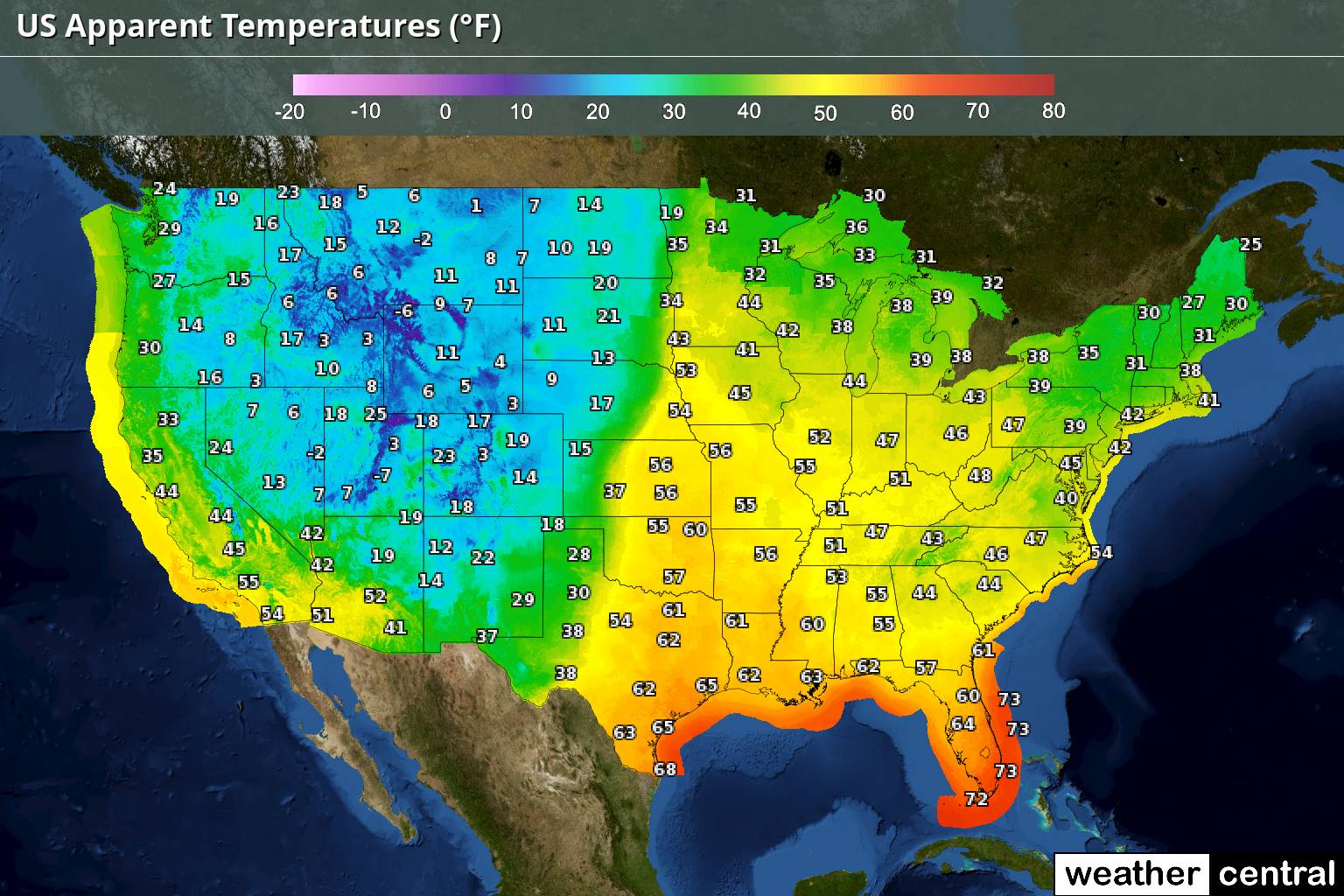
If you ask me these two maps scream a few things: 1. We are in the warm phase of El Nino. It's December 24th and those humidity charts are off the charts where is the cold dry air???? 2. It's going to be very difficult to move this moisture laden atmosphere out to establish cold air that is sustained. 3. The warming is well undeniable. I could see if it were July or August and we were looking at this humidity map, but even where it is cold it is humid?? 4. With that said warmer air holds more water and if it were to snow, I am sure it would be a 1-2 foot plus snowstorm. 5. These are our new normal I am afraid. 6. Any flow whatsoever off of a body of water Pacific, Gulf of Mexico, Atlantic, and now even the Great Lakes warms various levels of the atmosphere especially lower and mid-levels, and this is another obstacle of snow in this new era. We definitely would need a pattern progression eastward to even sniff a chance.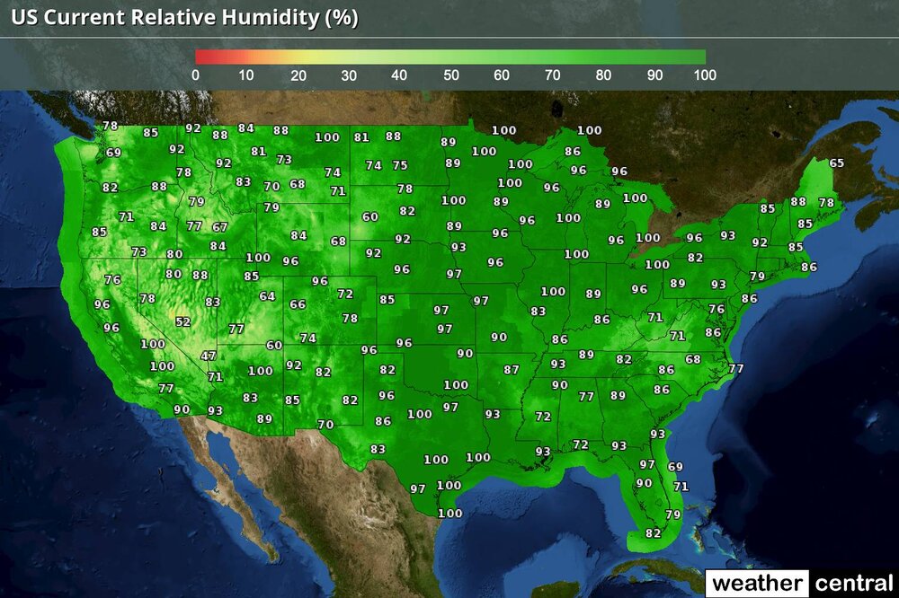

-
Yea we have been lacking this block the storms from coming straight at us please and more importantly slow the dam pattern down to phase a few storms to our east and southeast, but not too far.
-
E PA/NJ/DE Winter 2023-2024 OBS/Discussion
Kevin Reilly replied to The Iceman's topic in Philadelphia Region
The record books are about to be rewritten so hang on tight! -
Like December 5ths in the past in southern PA... It loves to snow January 6th and 7th around here just ask 1996!
-
Screams overrunning snows with weak areas of low pressure and the caboose of the lows is the storm that develops off the coast those are the classic 1–2-foot snowstorms around here.
-
You cannot ignore this because the models over the past three seasons show you what should be happening in a normal winter pattern then flip out and say but this is what you get; just like in Willy Wonka: "You Get Nothing"!!! "Good Day Sir"!!!
-
I think we watch this because that storm was once one consolidated storm now we are beginning to see redevelopment off the coast and the cold air is at least trying to catch up so I am still interested a bit in the 29th.
-
Well said my feelings exactly too!
-
The only thing that matters to me on that GFS Run was that there is a large storm. The storm is in two pieces but its a typical GFS thing to misunderstand the split of energy in a split flow. I am sure that the idea is one consolidated low east of the Delmarva instead which would net you a 1-2 foot snowstorm possibly more if there is decent blocking.
-
Warm tongue of air off the Atlantic Ocean way too much fetch it happens often lately going back over the past 15 years especially due to our torched Atlantic Ocean!
-
3.86 here in Media Delaware County generally 3-6" of rain in Southeastern PA lots of streams out of their banks winds basically 25-40 mph at times.
-
E PA/NJ/DE Winter 2023-2024 OBS/Discussion
Kevin Reilly replied to The Iceman's topic in Philadelphia Region
Media, Delaware County 3.86" ... on the way in Darby Creek over its banks in Darby. -
E PA/NJ/DE Winter 2023-2024 OBS/Discussion
Kevin Reilly replied to The Iceman's topic in Philadelphia Region
Now is that at the surface or 2,000 to 5,000 feet up off the surface. -
E PA/NJ/DE Winter 2023-2024 OBS/Discussion
Kevin Reilly replied to The Iceman's topic in Philadelphia Region
So far, this December has a 1980's feel to it a few flakes, rainstorms with wind and Temps hanging most days 38-48 with some wind to throw in. -
It's okay no worries 18z Model runs are notorious for being drier and further east and southeast with the storm development.
-
Hmmm there is more water surrounding the United States North American Continent and the South American Continent remember the waters are warm simply put the more land you have the colder the more water the warmer. Waters hold onto warmth longer than the land therefore your land locked areas are supremely colder landmasses than the landmasses surrounded by warm waters where warm air is free to flow from the warmer waters over to the land pushing away the cold air masses or not allowing them to move in.
-
Two things I like above: 1. That's a pretty strong storm that far south 992!! Move north a 992 should have no problem dragging down the cold air from the Great Lakes and western New England. If that 992 moves NNE and develops along the way it could be a blockbuster. I like this a lot! No blocking high so it should just move.
-
yea not sure a 1006 mb low will create its own cold air looks more like the 994 up off of Southern New England is sending colder air SSW but I would think this is bogus because the atmosphere will be flooded by Atlantic Warmth time will tell to see if something develops though.
-
Wonder if some of that is sleet which is exaggerating the accumulation?
-
Where are the 40mph+ winds at?
-
E PA/NJ/DE Winter 2023-2024 OBS/Discussion
Kevin Reilly replied to The Iceman's topic in Philadelphia Region
Canadian Model wins lol and it just hit 60 but we lost the sun now. -
Yes, I too wonder if this is the signal for the pattern change, but I have not really seen a 978 parked over Wilmington Delaware. I wonder if this storm is a tad further east and a storm that strong man 978 would manufacture its own cold air and there is cold air crashing southeast, so I am interested in that storm.
-
E PA/NJ/DE Winter 2023-2024 OBS/Discussion
Kevin Reilly replied to The Iceman's topic in Philadelphia Region
Second that! Trying to remember if we saw flakes at all in November or December last year (sarcasm). I am going with snow totals for the year of 20-30" for Delaware Co -
E PA/NJ/DE Winter 2023-2024 OBS/Discussion
Kevin Reilly replied to The Iceman's topic in Philadelphia Region
3K Nam flipped pretty quickly so there is that showed snow through the Delaware River into New Jersey. I think definitely I would side with the dynamical models here with this one models like the GFS just don't cut it. I like our chances for snow Monday Morning 4 am to 10 am especially the Delaware River west, northwest, north, and northeast. I will go with 1-3" mainly on the grass with wet to perhaps slushy roads especially north and west. -
Well take a look at the Cam we would be in paradise right now: Downtown Truckee | Tahoetopia