Kevin Reilly
-
Posts
2,935 -
Joined
-
Last visited
Content Type
Profiles
Blogs
Forums
American Weather
Media Demo
Store
Gallery
Everything posted by Kevin Reilly
-
100% agree with this and the warm waters remember Charlie and Ian DO NOT downplay this situation take it as a serious threat!
-
I’m checking in their driving up from Orlando Fl on August 11th hopefully the town is still there.
-
Yep swing and a miss where I’m at in Florida it’s coming on up after it’s done with Georgia and the Carolinas. Let it come we need it. Unfortunately our pattern has found many ways not to deliver. I’ll be driving behind it literally. Next stop Orlando to Charleston driving.
-
Waking up to sunny down here in Orlando. I’m not expecting too many impacts here? Don’t let your guard down up the coast with what probably will become Debby. What’s interesting too is I check into Charleston SC on August 11th. I guess I’ll be checking into the aftermath. We drove down from SE Pa hope the roads are passable in Georgia, SC, NC as I look at the models this morning.
-

2024 Atlantic Hurricane Season
Kevin Reilly replied to Stormchaserchuck1's topic in Tropical Headquarters
Waking up to sunny down here in Orlando. I’m not expecting too many impacts here? Don’t let your guard down up the coast with what probably will become Debby. What’s interesting too is I check into Charleston SC on August 11th. I guess I’ll be checking into the aftermath. We drove down from SE Pa hope the roads are passable in Georgia, SC, NC as I look at the models this morning. -
Waking up to sunny down here. Don’t let your guard down up the coast with what probably will become Debby. What’s interesting too is I check into Charleston SC on August 11th. I guess I’ll be checking into the aftermath. We drove down hope the roads are passable in Georgia, SC, NC as I look at the models this morning.

-
Hoping Media got some rain today? I’m down in Florida a state of emergency was just issued. Should be an interesting weekend down here.
-
Two centers not colocated together
-
If I look at the GFS thinking the northern circulation is the one it’s latched on to we shall see in time.
-
Yep in Savanah Ga right now heading to Florida until August 11th. Water temp 89-92 along west coast.
-
Hey how about those thunderstorms today with hail that rocked the area how did that pan out?
-
2024 Atlantic Hurricane Season
Kevin Reilly replied to Stormchaserchuck1's topic in Tropical Headquarters
I think in regard to rain and tropical threats this year that this is just the beginning for SE Texas sorry to say. -
2024 Atlantic Hurricane Season
Kevin Reilly replied to Stormchaserchuck1's topic in Tropical Headquarters
I agree. I think the models showing a bit of something on August 1st to 6th is kind of a precursor or warning of what is to come. Call it a false start the active period but the real active period begins around August 10th. August 1st to 6th is an appetizer sort to say. -
Mowed the dusty grass here. I have not seen this type of dryness here since August and early September of 1999 or July of 1988 take your pick very dry. Also, anyone noticing the smoke today in the sky pretty evident. I think Sosa lost the ball in the white skies today at second base.
-
2024 Atlantic Hurricane Season
Kevin Reilly replied to Stormchaserchuck1's topic in Tropical Headquarters
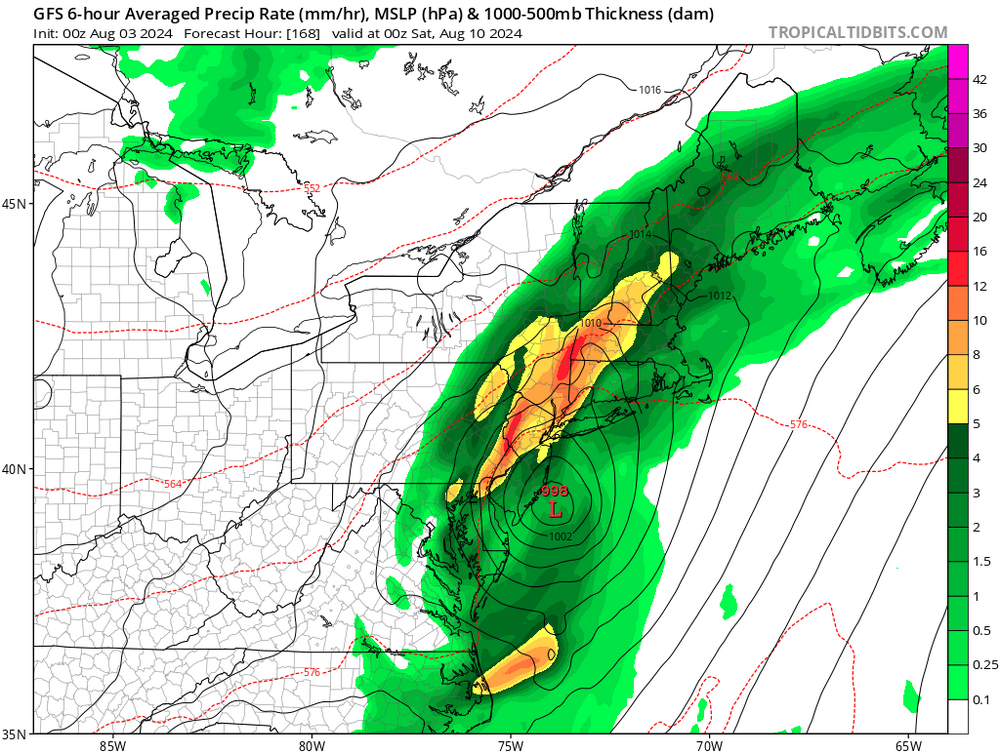
6z gfs onboard for tracking first 10 days of August. I’ll be in Orlando August 1st to 11th then heading to Charleston SC so I’m watching this. I’ll be driving so just make sure I’m at full most of ride as needed. Driving down from SE Pa.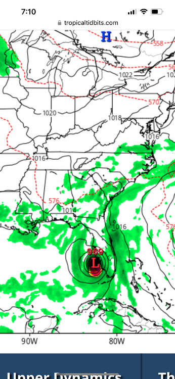
-
THATS where the Euro had development 0z run Wednesday however did lose it last nights run.
-
It probably will be because I’ll be down in Florida. It will be dry down there instead and wet here.
-
Just getting ready for Winter of 2024-2025.
-
Hurricane Floyd hit Delaware County very hard on September 17th, 1999, with serious flooding 10-15" of rain as it ran up along the cold front as a 45-mph tropical storm just a few miles offshore of the South Jersey coast moving NNE at 35 mph.
- 1,696 replies
-
- 1
-

-
- severe
- thunderstorms
- (and 5 more)
-
This is a typical outcome after a long dry period AKA 1999 Floydd
-
Moderate to heavy rain here last 30 minutes now tapering down some clear skies to the east and northeast now. 73.8f humidity 91% dewpoint 71f. Sun about to pop out here wonder if that heats things back up for more development shall see. Total rainfall in the gauge = 0.52"
-
Absolutely nothing to show for any of the rain happening now. We have a light outflow boundary wind blowing from the east NE from Philadelphia. Maybe we get lucky and get an outflow boundary collision for development.
-
So, here we go..... Heavy rain 20-30 miles north and northeast..... Heavy rain 30-35 miles southwest and zippo here getting pretty frustrating. Flash Flood Warning Philadelphia and Montgomery county in PA and Burlington and Camden County in NJ 84.2 humidity 76% feels like 93f ... a few peeks of sun
-
"following our fairly wet stretch of weather this month." Meanwhile only 42 miles to your southeast we have struggled to pick up 2.56" since May 25th! The only word that I can give the precipitation distribution for the entire area Harrisburg to Trenton to points south and east to Southern Delaware and Maryland .....eratic! Great information and write up as usual Paul! Thanks, from this section of Central Delaware County but I will tell you we are experiencing flash drought conditions and from the look of the landscape Moderate Drought. Springton Reservoir along Route 252 in Upper Providence and Marple Townships is dropping steadily the past few weeks. We know what will happen later August and September.... East Coast riding Hurricane! It's the La Nina way!
-
only 0.47" here and that came in 35 minutes late last night which the models did not predict at all. Otherwise that is 2.56" since basically Memorial Day Weekend.