-
Posts
2,935 -
Joined
-
Last visited
Content Type
Profiles
Blogs
Forums
American Weather
Media Demo
Store
Gallery
Everything posted by Kevin Reilly
-
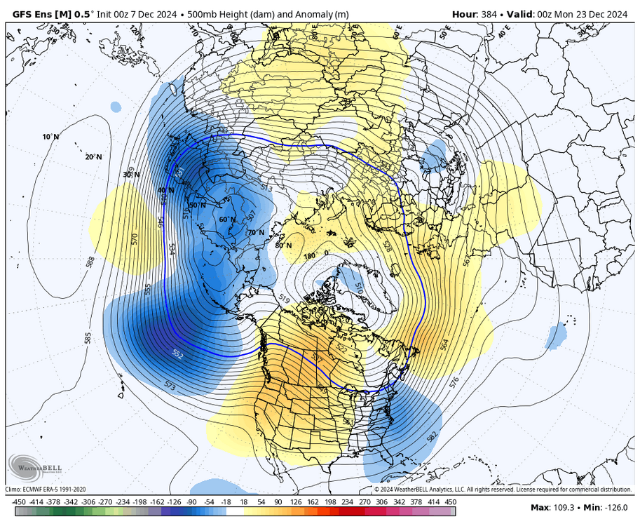
Looks like things are flipping to a El Nino like pattern at H5 soon... I wouldn't be so sure. Perhaps a few things this is a neutral year... or once again the Pacific is so warm compared to climatological averages that La Nina and El Nino doesn't me much.
- 1,105 replies
-
- tropics
- heavy rainfall
-
(and 5 more)
Tagged with:
-
A couple of things.... 1. Isn't that the hallmark of neutral conditions... 2. Or is it that the overall basin of the Pacific is that warm due to climate change...
-
We know what we all got in February 2003 it was pretty cool snowing at 6f here and Trenton was partly sunny we got nearly 20" of snow from that storm.
- 1,105 replies
-
- 1
-

-
- tropics
- heavy rainfall
-
(and 5 more)
Tagged with:
-
Forget January if we do not get snow on the ground to refill water tables we are absolutely screwed for June, July, and August it will be a drought that no one has ever seen around here before.
- 1,105 replies
-
- tropics
- heavy rainfall
-
(and 5 more)
Tagged with:
-
Wow see things have really gone to Sh....t a good guy in the great lakes all we can get is a bad guy anymore. That's when you know the sh...t has hit the fan.
- 1,105 replies
-
- tropics
- heavy rainfall
-
(and 5 more)
Tagged with:
-
39f humidity 53% dewpoint 23f had some light snow last hour officially call it a car topper here. Looks to be an interesting night and day tomorrow especially 6 am to 8 am snow squalls.
- 1,105 replies
-
- tropics
- heavy rainfall
-
(and 5 more)
Tagged with:
-
That is typically when we get smacked for some reason, I feel good about this situation here and it feels different than the past few years. It's the big ones we see far out.
-
I mean yea it is a significant move southeast and long leads is the key.
-
Yes need the northern branch with the cold high up north to move faster and the way things over the past few years have been going with the northern branch it would be surprising to see it move faster.
-
100-150 miles southeast is doable at this range this keeps my hopes alive along with the 6z Euro run from this morning. Also, with a Negative NAO peaking on or around December 10th and moving towards positive on December 15th it keeps me more interested.
-
Are you saying we have a chance!!! Now to some degree the 12z GFS did get a little closer on December 12th as it shifted the storm east and stronger so maybe the models are beginning to pick up on the progressiveness of the evolving pattern. Time will tell. I mean the NAO is negative moving towards positive on December 12th, so I am still interested in the 10th to 14th timeframe. Thank you for keeping hope alive!
- 1,105 replies
-
- 1
-

-
- tropics
- heavy rainfall
-
(and 5 more)
Tagged with:
-
Low last night here 21f looking forward to the 45 mph winds tomorrow and rain shower turning to snow squall. No Snow in sight after that more of the same from past winters temps heading to 60 next week then back to near normal and then probably going back up to that afterwards. Total Snowfall for Media Delaware County this year trace and counting.
- 1,105 replies
-
- tropics
- heavy rainfall
-
(and 5 more)
Tagged with:
-
Don't worry it will be 60 degrees soon.
-
What is also noteworthy of these years most of them had that one or two large snowstorms and many of them were coming off a Negative NAO rising towards positive. Standouts to me are Superstorm of March 1993, January 7th, 1996, December 19th, 2009, and February 2010.
-
Yes!!! Sleet pellets mixed with rain at the onset becoming all rain in say less than an hour; this seems very familiar the last few years.
-
I have been saying this now for going on 5 years. Welcome to the Pacific Dominant Winters where the warmer waters of the Pacific cause the Pacific Jet to dominate our winters in the lower 48. This is our new normal, which equals predominately warmer winters overall with a lot less snow in the east due to warming off the Pacific, Gulf of Mexico, and The Atlantic. Waters take longer to cool down and by the time we do cool down it is time to warm them back up again as the sun angle returns to the Northern Hemisphere.
-
Yes, as I said some models or Mets... because one local met in Philly who went to Mexico on a trip was calling for 2-4" two days before the storm was coming.... Yes, some Mets Dave Roberts WPVI and others had this pegged a week out. I suppose the met then calling for 2-4" wanted to be different then.
-
As for some models an example of this was January 7th, 1996, up here in Philadelphia.
-
Now minus the kitchen sink actually I like this look better for the fact we have a cold high up north introducing the cold air damming situation which is what we need with a NNE wind the surface blocking the warming off the ocean all about placement and timing of course.
-
I am an amateur on here really but in regard to the MJO I was looking at the word wide water vapor map and a few things stuck out to me and that was increasing tropical development just to the east of Tonga and south of Samoa out in the Southwest Pacific not sure that helps us invigorate a southern jet which is now flat and closed to us in Central Mexico and the Central Gulf of Mexico and out to sea off the Bahamas. I also saw a trough slipping SE through the Aleutians and a vigorous low to the southwest of the Aleutians slipping east southeast wondering if that begins a -PNA phase on the West Coast.
-
This is the solution it never fails. Also look no high up north again. Our normal winter has returned nice!
-
Well, I see we are truly back to the good old days with Euro burying energy out west and GFS sending the energy out all at once to create our snowstorm.
-
December 19, 2009, we had 23.2" of snow and the SST at ACY was 53f.
-
I think there was also a 20"+ storm for Cape May County and flurries at the same time for SE PA when we were supposed to get 4-8" instead we got dim sun through cirrus here with a blizzard along the board walk in Wildwood.
- 1,105 replies
-
- tropics
- heavy rainfall
-
(and 5 more)
Tagged with:
-
Currently Cloudy 51f becoming breezy here rain has left stage right high so far today 52f low 42f total rainfall 0.72" Total rainfall last two weeks: 2.45" Happy Thanksgiving to All!! Let's see if we can get a snow event in the first 10 days of December.
- 1,105 replies
-
- 1
-

-
- tropics
- heavy rainfall
-
(and 5 more)
Tagged with:


