Kevin Reilly
-
Posts
2,935 -
Joined
-
Last visited
Content Type
Profiles
Blogs
Forums
American Weather
Media Demo
Store
Gallery
Everything posted by Kevin Reilly
-

E PA/NJ/DE Winter 2024/25 Obs/Discussion
Kevin Reilly replied to JTA66's topic in Philadelphia Region
Think we got like 3” from that down here just trying to remember off the top of my head. -
Also keeping in mind this whole conversation is bumping about 8-10 miles north each run in some cases could make for very interesting totals further north in the coldest of air in regards to those rations. I don’t think this is done bouncing around quite yet until at earliest this time tomorrow.
-
Suggests more expansive precipitation field north through colder higher ratios works well wow normal winter.
-
E PA/NJ/DE Winter 2024/25 Obs/Discussion
Kevin Reilly replied to JTA66's topic in Philadelphia Region
It’s inching closer and closer for victory in Delaware County. I’m encouraged it’s probably nudging further north but not too much going forward. -
E PA/NJ/DE Winter 2024/25 Obs/Discussion
Kevin Reilly replied to JTA66's topic in Philadelphia Region
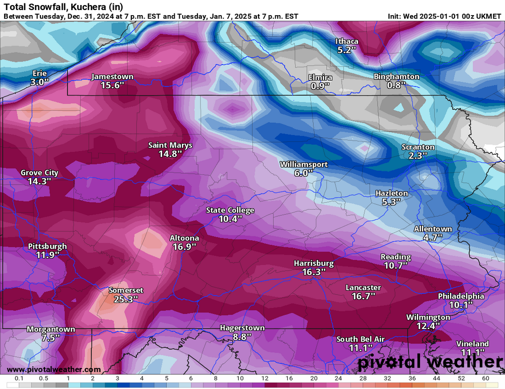
Soo February 2010 Media Delaware County picked up 23” of snow with winds gusting to 40-50 mph as the storm pulled away; not sure this set up will be anything like that. We have a relatively fast moving running under the block instead of into the block from the southwest. All in all snow is snow we shall focus on appetizers on Friday with arrival of the “real” cold air then hopefully the main course on Monday fingers crosse. -
E PA/NJ/DE Winter 2024/25 Obs/Discussion
Kevin Reilly replied to JTA66's topic in Philadelphia Region
Euro last 5 runs courtesy Mid Atlantic Forum: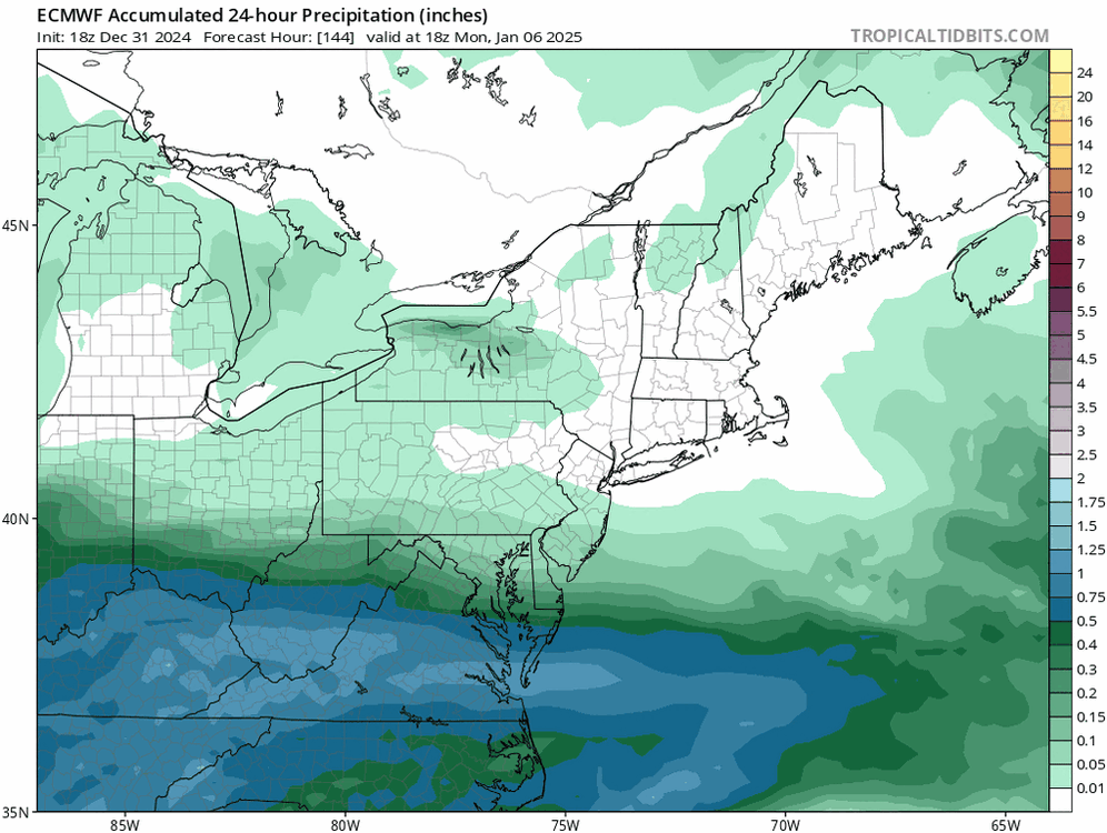
-
January Medium/Long Range: A snowy January ahead?
Kevin Reilly replied to mappy's topic in Mid Atlantic
The trend there is clear and apparent not a blip in regards to a more expansive precipitation field and storm track. Northern parts of this precipitation field is going to see higher snow ratios to overcome smaller qpf amounts typical winter stuff. -
E PA/NJ/DE Winter 2024/25 Obs/Discussion
Kevin Reilly replied to JTA66's topic in Philadelphia Region
Next round of following the ping pong ball. Crazy busy today haven't had time to look at really anything right now cannot say I am surprised with any of this trend. -
E PA/NJ/DE Winter 2024/25 Obs/Discussion
Kevin Reilly replied to JTA66's topic in Philadelphia Region
This is the beginning of a north trend I believe. Early next week storm is contingent on the gusty winds and storm tonight getting out of the way of the clipper coming in on Friday. We just cannot know the final outcome on the models until about 6z Friday, January 3rd. I truly think we are finally looking at a normal winter pattern here this year. We shall test that normalcy to see this storm to our south trend north in time. That is just my gut feeling at this time. I think the 0z models tonight trend north. -
E PA/NJ/DE Winter 2024/25 Obs/Discussion
Kevin Reilly replied to JTA66's topic in Philadelphia Region
My gut the way things have been working around here over the past few years is I think we do see a north trend today and tonight. I also think snow ratios will play a role somewhere in our area close by. -
E PA/NJ/DE Winter 2024/25 Obs/Discussion
Kevin Reilly replied to JTA66's topic in Philadelphia Region
Yep, early next week is pretty much dependent on spacing to the Friday system and also the strength of the confluence up north. We just cannot know with much certainty until at least later tomorrow night or first thing Friday if your looking at the models. -
E PA/NJ/DE Winter 2024/25 Obs/Discussion
Kevin Reilly replied to JTA66's topic in Philadelphia Region
Yep, probably the event / system that screws us out of snow on Monday and Tuesday, but we shall see. That almost looks kind of norlun troughy. -
E PA/NJ/DE Winter 2024/25 Obs/Discussion
Kevin Reilly replied to JTA66's topic in Philadelphia Region
Ukie says Happy 2025!!!
-
January: Medium/ Long Range: May the Force be with Us....
Kevin Reilly replied to Weather Will's topic in Mid Atlantic
You mean Thursday -
January: Medium/ Long Range: May the Force be with Us....
Kevin Reilly replied to Weather Will's topic in Mid Atlantic
I’m willing to bet the other models continue this trend and things start trending north a bit in time as this storm tonight that caused all of the thunderstorms and hail flies away to the NNE.
-
E PA/NJ/DE Winter 2024/25 Obs/Discussion
Kevin Reilly replied to JTA66's topic in Philadelphia Region
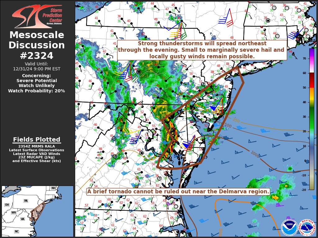
Ralph: Thoughts!
-
Rain will be through NYC by say 11:00 pm rapidly moving NE. Clear low center just southwest of Allentown, PA.
-
46f dead calm winds and skies are now partly cloudy to clear here. 0.50" Wild night here winds gusted past 40 mph a few times and had not 1, not 2, but 3 storms with hail. The second storm the hail was pea to marble size and covered the ground and cars too lots of cloud to ground lightning strikes wild signal for the beginning of our pattern change! Wow night! Happy New Year all!
-
E PA/NJ/DE Winter 2024/25 Obs/Discussion
Kevin Reilly replied to JTA66's topic in Philadelphia Region
That's one impressive radar for December 31st just wow!! NWS Radar -
E PA/NJ/DE Winter 2024/25 Obs/Discussion
Kevin Reilly replied to JTA66's topic in Philadelphia Region
You can see the pattern change happening before your eyes on the water vapor map pretty amazing. It is flipping storm over us headed to set up the confluence and bring the cold out of Canada. You can see everything collapsing down from eastern Alaska and the Yukon so here comes the cold charging SE. Forget the models right now but you can see an emerging winter pattern easily on the water vapor map. -
E PA/NJ/DE Winter 2024/25 Obs/Discussion
Kevin Reilly replied to JTA66's topic in Philadelphia Region
Looks like bow echo to the south and east is getting energized again and moving North Northeast. temp up a degree here to 48f remain in a dry slot. -
E PA/NJ/DE Winter 2024/25 Obs/Discussion
Kevin Reilly replied to JTA66's topic in Philadelphia Region
Just got dry slotted LOL 47f Looks like the line to my south now moving west northwest. -
E PA/NJ/DE Winter 2024/25 Obs/Discussion
Kevin Reilly replied to JTA66's topic in Philadelphia Region
Geeze
-
E PA/NJ/DE Winter 2024/25 Obs/Discussion
Kevin Reilly replied to JTA66's topic in Philadelphia Region
Looks like another solid line developing in NE Maryland and northern Delaware heading quickly North wow this is a very active night! A New Years Eve to remember lol. Total rainfall 0.40" so far with a covering of hail. Happy New Years all!