

sussexcountyobs
-
Posts
1,510 -
Joined
-
Last visited
Content Type
Profiles
Blogs
Forums
American Weather
Media Demo
Store
Gallery
Everything posted by sussexcountyobs
-
Starting to get confusing on these threads to follow what storm and date we are talking about?
-
OBS and nowcast mainly midnight - Noon Thursday Feb 11
sussexcountyobs replied to wdrag's topic in New York City Metro
Snow is over. 1/2" -
OBs and nowcast TUESDAY 2A-6P Feb 9, 2021
sussexcountyobs replied to wdrag's topic in New York City Metro
It happens. I tend to usually do better with coastal being further east than you. We're over 53" for the season.- 82 replies
-
- 1
-

-
- snow
- freezing rain
- (and 1 more)
-
OBs and nowcast TUESDAY 2A-6P Feb 9, 2021
sussexcountyobs replied to wdrag's topic in New York City Metro
Final was 2.5" by me.- 82 replies
-
- 2
-
-

-
- snow
- freezing rain
- (and 1 more)
-
OBs and nowcast TUESDAY 2A-6P Feb 9, 2021
sussexcountyobs replied to wdrag's topic in New York City Metro
4am. Snow falling. 20° Everything including roads covered.- 82 replies
-
- 2
-
-
-
- snow
- freezing rain
- (and 1 more)
-
OBs and nowcast TUESDAY 2A-6P Feb 9, 2021
sussexcountyobs replied to wdrag's topic in New York City Metro
19.8/7.5 -
Additional 1-5" snow mostly North of I80 Tuesday Feb 9
sussexcountyobs replied to wdrag's topic in New York City Metro
Winter weather advisory up for 3-4" of snow tomorrow. -
Obs and nowcast Super Bowl Sunday 4A-6P Feb 7, 2021
sussexcountyobs replied to wdrag's topic in New York City Metro
Just measured 2.6" with light snow falling. -
Taken with a grain of salt. My Wunderground forecast is calling for 24+ of snow, not counting today, till Feb. 22nd.
-
Obs and nowcast Super Bowl Sunday 4A-6P Feb 7, 2021
sussexcountyobs replied to wdrag's topic in New York City Metro
Just measured only 1.75" new here. Steady light snow. 30° -
Obs and nowcast Super Bowl Sunday 4A-6P Feb 7, 2021
sussexcountyobs replied to wdrag's topic in New York City Metro
Moderate snow falling. Just measured. .7" new 27.8° -
Obs and nowcast Super Bowl Sunday 4A-6P Feb 7, 2021
sussexcountyobs replied to wdrag's topic in New York City Metro
Mt Holly talked about that early yesterday morning when they dropped the WSW for coastal Ocean County. -
Obs and nowcast Super Bowl Sunday 4A-6P Feb 7, 2021
sussexcountyobs replied to wdrag's topic in New York City Metro
Plow just came by spreading salt and grit. -
Obs and nowcast Super Bowl Sunday 4A-6P Feb 7, 2021
sussexcountyobs replied to wdrag's topic in New York City Metro
Steady snow. Streets getting white. -
Obs and nowcast Super Bowl Sunday 4A-6P Feb 7, 2021
sussexcountyobs replied to wdrag's topic in New York City Metro
Light snow falling now. -
2-7-21 Sunday 8-12 hour nor'easter snowstorm roughly 5A-5P
sussexcountyobs replied to wdrag's topic in New York City Metro
Temps seem alot warmer this morning than was forecast around the area. -
2-7-21 Sunday 8-12 hour nor'easter snowstorm roughly 5A-5P
sussexcountyobs replied to wdrag's topic in New York City Metro
Don't know about out in PA. But it is virga here in Vernon. -
2-7-21 Sunday 8-12 hour nor'easter snowstorm roughly 5A-5P
sussexcountyobs replied to wdrag's topic in New York City Metro
26F here. Locked and loaded, ready to go. -
2-7-21 Sunday 8-12 hour nor'easter snowstorm roughly 5A-5P
sussexcountyobs replied to wdrag's topic in New York City Metro
Let's all remember this call tomorrow afternoon.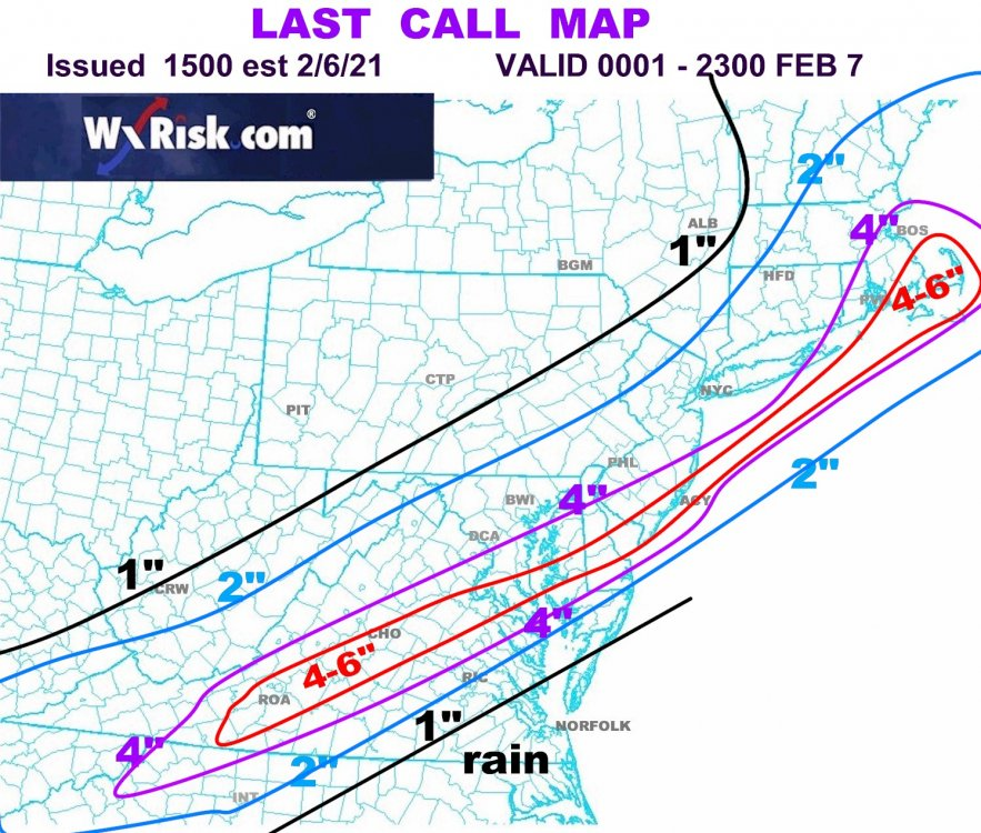
-
2-7-21 Sunday 8-12 hour nor'easter snowstorm roughly 5A-5P
sussexcountyobs replied to wdrag's topic in New York City Metro
So according to your forecast and snow map, here in NE Sussex County NJ we are 1-2" ? -
2-7-21 Sunday 8-12 hour nor'easter snowstorm roughly 5A-5P
sussexcountyobs replied to wdrag's topic in New York City Metro
Free. -
2-7-21 Sunday 8-12 hour nor'easter snowstorm roughly 5A-5P
sussexcountyobs replied to wdrag's topic in New York City Metro
Steve D. Put a video out around noon today. Not MIA? -
2-7-21 Sunday 8-12 hour nor'easter snowstorm roughly 5A-5P
sussexcountyobs replied to wdrag's topic in New York City Metro
FWIW. My forecast has been 3-5" for 2 days. On the NWS 4pm update, they raised the upside by 2". Now says 3-7". Alot of times when you are 12-16 hrs from event start time, it is time to stop relying so heavily on what models show run to run. -
2-7-21 Sunday 8-12 hour nor'easter snowstorm roughly 5A-5P
sussexcountyobs replied to wdrag's topic in New York City Metro
Alot of times when you are 12-16 hrs from event start time, it is time to stop relying so heavily on what models show run to run. -
2-7-21 Sunday 8-12 hour nor'easter snowstorm roughly 5A-5P
sussexcountyobs replied to wdrag's topic in New York City Metro
As per Mt. Holly 11am update Storm Details: Timing... In stark contrast to the system earlier this week, this will be a quick hitter with most of the precipitation being in and out of the area in about 12 hours. Precipitation should begin working into the area from SW-NE around 06-09Z with precipitation reaching far NW areas by 12-15Z. The system`s departure will also be rapid with precipitation largely ending from SW-NE between 18-21Z. Precipitation Types... Unlike the previous two significant winter events we had, there will not be a cold/dry antecedent airmass in place when precipitation begins early Sunday morning. Rather a "stale" airmass characterized by temperatures in the low 30s and dewpoints in the upper 20s/lower 30s will be in place. Additionally the heaviest snowfall will likely occur during the daytime hours, which while not overly significant in early February, can limit accumulations somewhat. The one pro for snowfall accumulations will be the intensity of lift within the aforementioned FGEN band, and dynamical cooling within this band should nudge temperatures down. Given all these factors, expect that areas NW of I-95 will see nearly all snow, areas near I-95 will likely see mostly snow, but could see some rain mix in at times (particularly when rates are low), with some mixing likely in southern Delmarva and the Coastal Plain of NJ. Given that we won`t really have a CAD setup in place think significant sleet is unlikely, although right at ptype transition zones we could see it briefly mix in. Snow Amounts... A very challenging forecast given uncertainties in both the northward extent of QPF, and the southward extent of accumulating snowfall. After a consistent northward/more amplified trend Thursday, there has been a bit of "windshield wipering" the last couple cycles with the low`s placement and thus the resulting placement of QPF/snowfall. The latest consensus is a low positioned a bit further SE of the 18Z suite`s consensus, which would place the I-95 corridor in the sweet spot of this event (i.e. the intersection of sufficiently cold profiles and sufficiently high QPF) and the current placement of the winter storm warning reflects this. However, any northward shifts would likely cut snow amounts (due to increased mixing) near and SE of I-95 while bumping up amounts in the NW, with the converse happening with a any southern shifts. But, assuming a perfect prog, amounts in the 4-7 inch range look likely in the vicinity of the I-95 corridor with 3-5 inch amounts buffering this on either side (where advisories are in place). The most significant modifications to the snowfall forecast with this package was near the coast, where a mix with rain looks likely and amounts will largely be under 2 inches. It should be noted that there is the potential for higher snowfall amounts within the band (where rates may approach 2 inches an hour), but would like to really get in the CAMs temporal wheelhouse (e.g. <24 hours) before increasing amounts further.
