

GaWx
-
Posts
14,716 -
Joined
Content Type
Profiles
Blogs
Forums
American Weather
Media Demo
Store
Gallery
Everything posted by GaWx
-
Historic Pacific Northwest Heatwave of 2021
GaWx replied to donsutherland1's topic in Climate Change
As of Noon PDT vs 24 hours earlier, this is how much hotter it is: Portland 7 F SeaTac 6 F Pendleton 6 F Walla Walla 5 F Spokane 4 F Yakima (airport) 2 F -
My feeling is that if they’re going to investigate this that it be today rather than tomorrow afternoon, when it would already be nearly onshore.
-
Historic Pacific Northwest Heatwave of 2021
GaWx replied to donsutherland1's topic in Climate Change
Looking at 10AM PDT readings vs 24 hours ago: Portland, Walla Walla, Pendleton, and Yakima are 6 F warmer. Spokane area is 4-5 F warmer. SeaTac is 3 F warmer. Keep in mind that June records were already obliterated in Portland, Seattle-Tac, and other locations yesterday! -
Historic Pacific Northwest Heatwave of 2021
GaWx replied to donsutherland1's topic in Climate Change
@donsutherland1and others, Do I think AGW is contributing to this? I strongly feel that way. The globe is ~2F warmer than it was just since the 1970s and ~3 warmer than 1900 if I’m not mistaken. And this is the fourth extreme heatwave just this month to go along with Desert SW, N Plains, and Russia as Don pointed out. But is the likely contribution to this more than, say, 2-3F? That’s impossible to know. One thing that is an additional major contributor is the widespread drought in the area (see below), likely caused largely by La Niña, combining with the very anomalous Pacific NW ridge. Do y’all think the AGW contribution to this heatwave is likely more than ~2-3F? Do you think that the widespread W US drought is a bigger contributor? I'm strongly suspecting it is based on the physics of air heating up more over drier soils due to their much lower specific heat levels. Would we be looking at a historic heatwave had there been no drought? I have a lot of doubt about that and also suspect that there wouldn't be as strong a ridge there without the drought. Also, note that the 3 big US heatwaves have all occurred in widespread drought regions as per the map below: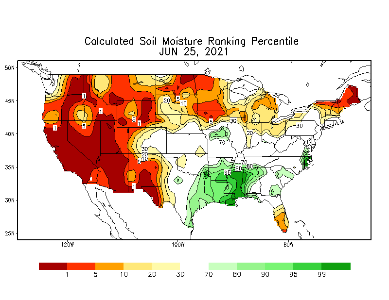
-
Severe June 2021 Heatwave in Phoenix and Tucson
GaWx replied to donsutherland1's topic in Climate Change
It appears you're indirectly referring to UHI, which I think is a legitimate significant factor for Phoenix in addition to AGW as I mentioned. But keep in mind that UHI mainly affects minimums. The increase in average maximums is likely mainly related to AGW imo and Don mainly emphasized maximums.- 33 replies
-
- 2
-

-
- heatwave
- extreme heat event
- (and 5 more)
-
Severe June 2021 Heatwave in Phoenix and Tucson
GaWx replied to donsutherland1's topic in Climate Change
@donsutherland1, excellent analyses from one of the best and most objective analyzers of data here. As much as I like your posts ITT, I think they would have been even better if you had mentioned the very likely additional significant role of UHI on mainly Phoenix’s minimum temperatures. I assume you’d agree that UHI has contributed much more to higher minimums than to higher maximums and is I believe the main reason why minimums have increased by a significantly higher amount vs the increase for maximums. So, I feel that higher minimums are due to a combo of UHI and AGW, with each having significant effects. For this reason, in order to get the best feel for AGW’s effects independent of UHI, I tend to focus only on maximums as I believe that the vast majority of those increases has been due to AGW. To be fair, you have focused much more on those.- 33 replies
-
- 2
-
-
- heatwave
- extreme heat event
- (and 5 more)
-
Hi Don, I respect you immensely and therefore feel the need to tell you that it looks like there’s a major problem with the Yakutat temperature sensor. Please check out this link to hourlies for the last few days: https://w1.weather.gov/data/obhistory/PAYA.html a t e Time (akst) Wind (mph) Vis. (mi.) Weather Sky Cond. Temperature (ºF) Relative Humidity Wind Chill (°F) Heat Index (°F) Pressure Precipitation (in.) Air Dwpt 6 hour altimeter (in) sea level (mb) 1 hr 3 hr 6 hr Max. Min. 17 17:53 E 5 10.00 Overcast BKN037 OVC055 36 29 76% 32 NA 29.33 993.3 17 16:53 NE 7 10.00 A Few Clouds FEW029 35 28 76% 29 NA 29.34 993.6 17 15:53 E 3 10.00 Mostly Cloudy SCT030 SCT040 BKN050 36 30 79% NA NA 29.35 993.8 17 14:53 E 9 10.00 Overcast OVC036 36 30 79% 29 NA 29.36 994.2 17 13:53 E 8 10.00 Light Rain OVC040 36 30 79% 30 NA 29.37 994.6 17 12:53 E 6 10.00 Light Rain FEW027 BKN040 OVC055 35 32 89% 30 NA 29.37 994.5 17 11:53 Calm 10.00 Light Rain BKN038 OVC045 NA NA NA NA NA 29.36 994.4 17 10:53 Calm 10.00 Mostly Cloudy SCT046 BKN055 NA NA NA NA NA 29.35 994.1 17 09:53 NE 3 10.00 Mostly Cloudy BKN050 NA NA NA NA NA 29.35 994.1 17 08:53 Calm 10.00 Partly Cloudy SCT085 NA NA NA NA NA 29.33 993.4 17 07:53 Calm 10.00 Partly Cloudy SCT120 NA NA NA NA NA 29.33 993.4 17 06:53 Calm 10.00 Mostly Cloudy BKN110 NA NA NA NA NA 29.34 993.7 17 05:53 Calm 10.00 Partly Cloudy SCT110 NA NA NA NA NA 29.36 994.4 17 04:53 Calm 10.00 Partly Cloudy SCT100 NA NA NA NA NA 29.38 995.1 17 03:53 NE 5 10.00 A Few Clouds FEW038 NA NA NA -11 NA 29.41 996.1 17 02:53 E 3 10.00 Mostly Cloudy BKN044 NA NA NA NA NA 29.44 997.1 0.01 17 01:53 NE 5 10.00 Overcast SCT034 OVC042 NA NA NA -11 NA 29.47 998.1 17 00:53 E 5 10.00 Mostly Cloudy BKN028 NA NA NA -11 NA 29.50 999.1 16 23:53 NE 7 10.00 Overcast BKN026 OVC033 NA NA NA -13 NA 29.54 1000.5 0.01 0.01 16 22:53 NE 8 10.00 Overcast BKN023 BKN036 OVC044 NA NA NA -14 NA 29.57 1001.5 16 21:53 E 9 10.00 Overcast OVC021 NA NA NA -15 NA 29.58 1001.8 16 20:53 E 8 10.00 Overcast BKN020 BKN025 OVC033 NA NA NA -14 NA 29.60 1002.5 0.07 16 19:53 NE 7 10.00 Mostly Cloudy FEW018 SCT025 BKN120 NA NA NA -13 NA 29.61 1002.9 16 18:53 NE 7 10.00 Overcast FEW021 BKN055 OVC110 NA NA NA -13 NA 29.62 1003.2 16 17:53 E 6 10.00 Overcast SCT018 OVC120 NA NA NA -12 NA 29.64 1003.9 0.01 0.07 16 16:53 Calm 5.00 Light Rain BKN017 OVC023 NA NA NA NA NA 29.65 1004.2 0.04 16 15:53 E 7 10.00 Overcast OVC011 NA NA NA -13 NA 29.66 1004.6 0.02 16 14:53 E 5 4.00 Rain BKN009 OVC013 NA NA NA -11 NA 29.67 1004.9 0.08 0.24 16 13:53 E 10 8.00 Light Rain OVC008 NA NA NA -16 NA 29.66 1004.6 16 12:53 E 8 10.00 Overcast OVC006 NA NA NA -14 NA 29.66 1004.6 0.07 16 11:53 E 9 3.00 Light Rain FEW008 BKN013 OVC023 48 38 68% 44 NA 29.64 1003.7 0.06 0.09 16 10:53 E 9 3.00 Light Rain OVC012 52 37 57% NA NA 29.63 1003.3 0.03 16 09:53 E 8 3.00 Light Rain Fog/Mist OVC016 37 36 96% 31 NA 29.61 1002.7 16 08:53 E 10 10.00 Light Rain OVC033 37 35 57 37 93% 30 NA 29.59 1002.1 0.04 0.13 16 07:53 E 8 9.00 Light Rain OVC027 37 35 93% 31 NA 29.58 1001.8 0.04 16 06:53 E 5 10.00 Light Rain OVC026 48 35 61% 46 NA 29.58 1001.8 0.02 16 05:53 SE 3 10.00 Light Rain OVC030 51 33 50% NA NA 29.58 1001.5 0.01 0.03 16 04:53 SE 7 10.00 Light Rain OVC034 55 32 42% NA NA 29.57 1001.3 0.01 16 03:53 SE 7 10.00 Light Rain OVC034 55 34 45% NA NA 29.55 1000.7 0.01 16 02:53 E 9 10.00 Light Rain OVC048 56 33 61 42 42% NA NA 29.52 999.8 16 01:53 E 5 10.00 Overcast OVC046 50 28 43% 48 NA 29.53 1000.0 16 00:53 NE 6 10.00 Light Rain OVC050 55 27 34% NA NA 29.53 1000.0 15 23:53 E 5 10.00 Overcast OVC050 53 27 37% NA NA 29.54 1000.4 15 22:53 E 6 10.00 Overcast OVC060 53 25 34% NA NA 29.55 1000.7 15 21:53 E 7 10.00 Overcast OVC060 49 25 39% 46 NA 29.56 1001.0 15 20:53 NE 12 10.00 Overcast BKN070 OVC090 51 24 60 36 35% NA NA 29.58 1001.6 15 19:53 E 6 10.00 Overcast FEW055 BKN070 OVC100 58 26 29% NA NA 29.61 1002.8 15 18:53 E 6 10.00 Overcast OVC055 51 27 39% NA NA 29.64 1003.6 15 17:53 E 5 10.00 Mostly Cloudy BKN055 49 28 44% 47 NA 29.65 1004.2 15 16:53 SE 5 10.00 Overcast OVC055 54 29 38% NA NA 29.68 1005.0 15 15:53 E 3 10.00 Mostly Cloudy FEW050 BKN060 BKN075 37 30 76% NA NA 29.70 1005.9 15 14:53 Calm 10.00 Partly Cloudy SCT046 40 29 56 40 65% NA NA 29.73 1006.7 15 13:53 E 6 10.00 Overcast FEW049 OVC065 49 30 48% 46 NA 29.76 1007.8 15 12:53 NE 8 10.00 Mostly Cloudy BKN035 BKN046 43 30 60% 38 NA 29.78 1008.5 15 11:53 NE 8 10.00 Overcast SCT033 BKN040 OVC047 52 31 45% NA NA 29.81 1009.4 15 10:53 E 9 10.00 Overcast BKN040 OVC048 56 29 36% NA NA 29.83 1010.0 15 09:53 E 6 10.00 Light Rain OVC041 54 29 38% NA NA 29.84 1010.4 15 08:53 E 6 10.00 Overcast FEW033 BKN046 OVC060 51 30 54 41 45% NA NA 29.84 1010.4 15 07:53 E 6 10.00 Mostly Cloudy BKN048 BKN065 51 30 45% NA NA 29.84 1010.6 15 06:53 NE 8 10.00 Overcast OVC048 46 30 54% 42 NA 29.86 1011.0 15 05:53 NE 9 10.00 Overcast OVC046 47 31 54% 43 NA 29.87 1011.6 15 04:53 NE 7 10.00 Overcast OVC044 47 31 54% 44 NA 29.89 1012.1 15 03:53 NE 6 10.00 Overcast OVC043 47 31 54% 44 NA 29.90 1012.5 15 02:53 NE 7 10.00 Overcast OVC046 49 31 51 38 50% 46 NA 29.91 1012.7 15 01:53 E 5 10.00 Overcast OVC048 43 31 63% 40 NA 29.92 1013.3 15 00:53 NE 6 10.00 Overcast OVC048 46 31 56% 43 NA 29.93 1013.6 14 23:53 E 5 10.00 Overcast OVC047 46 32 58% 44 NA 29.94 1013.7 14 22:53 E 3 10.00 Overcast FEW024 BKN039 OVC049 46 32 58% NA NA 29.94 1013.7 14 21:53 E 6 10.00 Overcast FEW026 SCT037 OVC047 50 32 50% 48 NA 29.94 1013.7 14 20:53 E 3 10.00 Overcast OVC034 50 32 55 39 50% NA NA 29.94 1013.9 14 19:53 E 3 10.00 Mostly Cloudy BKN120 55 32 42% NA NA 29.94 1014.0 14 18:53 NE 6 10.00 Mostly Cloudy BKN038 46 34 63% 43 NA 29.95 1014.3 D a t e Time (akst) Wind (mph) Vis. (mi.) Weather Sky Cond. Air Dwpt Max. Min. Relative Humidity Wind Chill (°F) Heat Index (°F) altimeter (in Don, here are just 2 examples of hourlies that look bogus: 1. 16:53 on 12/15 is at 54 F, a rise of a whopping 17 in one hour from the 37 the previous hour while overcast?? That can’t be. And the winds didn’t change much. Light E to light SE. So, no major warm front/airmass change it would appear. 2. At 9:53 on Dec 16th it was 37 and it then rose a whopping 15 in one hour under light rain to 52 with continued light E winds. I may post more later about the problems with this station when time permits.
-
Thanks, Lookout! Much appreciated, especially when coming from a class act and knowledgeable poster as yourself! I would say that Perry is WAY more knowledgeable than me regarding W and SW metro Atlanta for sure. Also, he has the first hand DETAILED reports from relatives that go so far back. My pre-1978 ATL wx related posts have been official/newspaper/city oriented since neither I nor any relatives were in ATL. My personal experiences are much more recent and largely northern burb oriented since I've lived in the N burbs since 1980. OTOH, even his own experiences in/near Douglasville go back well into the 60's. I think he was born around 1961. So, I wouldn't put myself ahead of him by any means in the overall Atlanta metro related wx history category and I'd clearly be behind in certain aspects. Regardless, I do think our posts do well together since we have different perspectives. Aside: I do feel I win the Savannah wx history category easily..well that's very easy since nobody else posts regularly about historical Savannah wx events. Fewer seem to care about Savannah I assume since fewer members live in that area. You and Perry are certainly THE two GA legends of WWBB. Also, it is time to talk about Lookout, himself. You, yourself, were THE only regular NE GA poster on WWBB as I recall when I arrived in Dec. '01. You have represented NE GA quite well since at least when I started at WWBB. Your very detailed posts about your backyard obs have been second to none. Also, your passion for exciting/stormy/wintry wx has been hard to beat. Through your detailed posts and obs., the reader has been able to experience the events as if they were actually living there. Also, your wx knowledge has to be among the top of all WWBB veteran amateurs. This includes CAD, among other wx phenomena. Your CAD posts and knowledge have always been top notch and have taught me things to help here in Atlanta during CAD. Also, you still know much more than me when it comes to reading soundings. You've been quite generous in sharing the sounding info in posts during wintry precip. events, including those for KATL when I've requested. Furthermore your general model interpretation skills for N GA are hard to beat. The non-GA folks are probably getting nauseous from our mutual GA poster complimenting by this point lol. Edit: Not to get too offtrack but : Although he's much newer, Tony (dsaur) is probably the new #1 poster when it comes to longtime personal and very detailed Atlanta area historical wx posts that go back prior to the late 1970's. I think I've seen some as far back as the 1950's. I especially love his accounts of old ZR (especially Jan. 1973) and old IP storms in the ATL area. Plus he cracks me up constantly..probably more than any other SE poster at least. I make sure not to be drinking anything or even eating ice ceam when reading his posts. I don't want to make a mess!!
-
Lookout, My guess is that you're referring to the excellent poster, Perry/(aka SouthernWx), someone for whom I have deep respect due to his knowledge of Atlanta area wx history and his ability to make very interesting and informative posts about it. This knowledge is partially due to his excellent records/recall from his older relatives, including one of his grandmothers, that cover as far back as at least to the 1940's. I wish he would resume his frequent posting, but I know his health isn't great. He helped inspire me to post similar Atlanta related info though from a somewhat different perspective (library based microfilmed ATL newspapers a big source instead of relatives since I'm from Savannah; also, mine was centered more on Atlanta, itself, and the N burbs as opposed to his family's area W and SW of town). Due to this, some have gotten us two mixed up, which is always an honor for me. I didn't join WWBB until much later....late 2001 (so, I'm a relative newbie in comparison) when I posted those op. GFS (then called MRF/AVN) cold bias tests ad nauseum during that winter of false frigid alarms on the MRF/AVN. I think even you got sick of them..can't blame you lol...but I still don't regret doing them because the bias was absurdly ridiculous and I thought that was the best way to display it. Let me know if it is Perry. I'm just educatedly guessing.
-
The way the first half of Oct. 2012 is looking per models, it would appear that it will likely be a good bit colder than 1991 fwiw. However, that would only put a fairly small dent in the +1.6. Nov. 1991 was quite chilly. So, it will be quite difficult for 11/2012 to be colder than that 11/1991. Now, Dec. 1991 was very warm. So, if we could get a cold Dec., rather big gains could be made then. Regardless, overcoming 1.6 F in Oct.-Dec. will be very tough.
-
Although you're one of the more highly regarded SE posters, I don't think most here feel you've quite made it to to the level of rainstorm, an extremely highly regarded former poster. Regardless, you're getting close. Rainstorm would be very proud of your great progress. No matter what, you're still the beloved People's Weenie, a very honorable, respected, and important role for the SE BB.