GaWx
-
Posts
14,719 -
Joined
Content Type
Profiles
Blogs
Forums
American Weather
Media Demo
Store
Gallery
Everything posted by GaWx
-
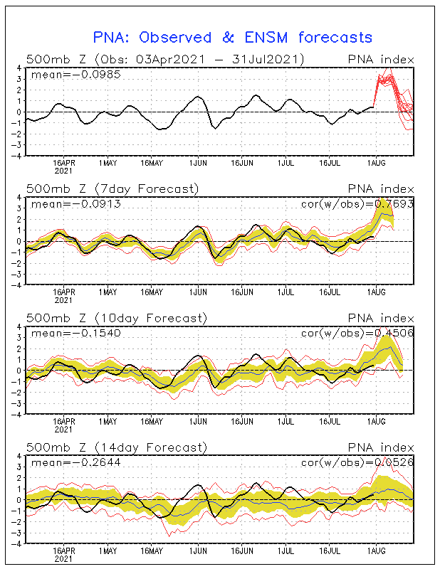
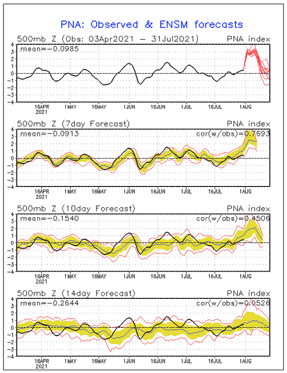
The GEFS runs of the last few days have been predicting an unusually strong +PNA coming up in early August. Here's today's GEFS PNA forecast, which if anything is a bit stronger overall: Based on this forecast, the PNA is going to skyrocket the next 2 days and approach, if not reach, 2 tomorrow (8/1) and approach, if not reach, 3 on 8/2. Afterward, the mean suggests it will quite possibly drop slightly on 8/3 before probably rising again some. It is projected to be 2+ anywhere from 6 to 8 days within 8/1-8 with 8/2-7 very likely being 2+. Also, it is projected to be 2.5+ anywhere from 4 to 6 days within 8/2-7 with 8/3-6 having a good chance to be 2.5+. There quite possibly will be several days over 3 within 8/2-6. The largest # of days on record at 3+ back to 1950 for any one peak is only two, which occurred 9/23/08 and 9/24/08. The two days of 3+ could be matched and maybe even exceeded. The highest PNA on record is 3.397 from 9/24/2008. It will probably get pretty close to that with some chance to even exceed it. There have been only four other peaks on record with a 3+: 8/1/2009, 7/2/1982, 9/28/1979, and 9/30/1959. So, interestingly enough, three of the five peaks at 3+ were within Sept 24-30 and all 6 were during JAS. Thus, the upcoming peak in early Aug is sort of in line with very strong peak climo. Now check out the peak dates for the 11 recorded peaks of 2.5+: 7/2, 7/14, 8/1, 9/24, 9/24, 9/26, 9/28, 9/30, 9/30, 10/4, and 10/6 Note how they're so concentrated within 9/24-10/6 with 8 of the 11 within that 13 day period! I'd love to know the reason. The largest # of days in a row on record of 2.5+ is six (9/22-27/2008). That run of six at 2.5+ has a chance to be matched. The largest # of days in a row on record of 2.0+ is eight (6/27-7/4/1982 and 9/27-10/4/1979). These runs of eight days at 2.0+ have some chance to be matched though that would very likely require it to reach 2 tomorrow. After these, the next longest are 7 days (9/22-28/2008 and 10/5-11/1953). Here are the number of recorded periods with peaks of 2+ by month: Jan 0 Feb 2 Mar 0 Apr 2 May 2 Jun 7 Jul 7 Aug 12 Sep 16 Oct 10 Nov 1 Dec 0 So, since 1950, there were only 7 peaks of 2+ during Nov-May or once every 10 years with the highest being only 2.353! Only 2 of the 72 DJFs had one and they were both in very late Feb: 2/29/68 and 2/28/83. OTOH, a whopping 38 of the 59 occurred during ASO with all 10 in Oct during Oct 1-12! Source for daily PNA back to 1950: ftp://ftp.cpc.ncep.noaa.gov/cwlinks/norm.daily.pna.index.b500101.current.ascii
-
To followup, here’s today’s GEFS PNA forecast, which is very similarly suggesting a near +3 within the first few days of August:
-
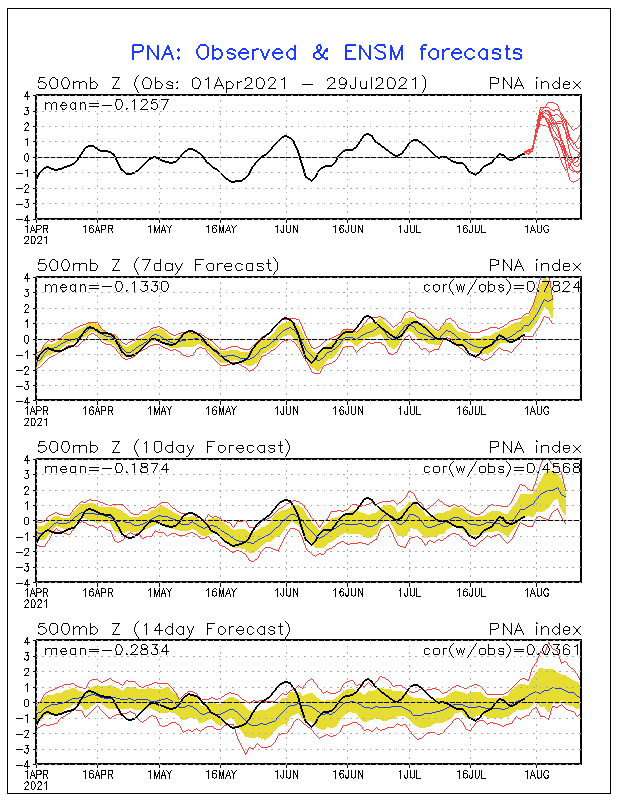
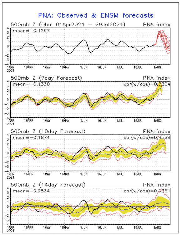
I'm not Don but I follow the indices closely. Assuming the forecast verifies pretty well, which is highly likely this close based on GEFS PNA forecasts having done quite well, the upcoming peak would be highly anomalous though not really all that extraordinary because ASO strongly + peaks occur much more often for some reason than during other months as you'll see below. And that's nothing new. I'd love to know the reason! (Aside: So, there's really no clear-cut evidence to connect this to AGW/CC imo. I'm mentioning this only because this is a CC thread). The GEFS is suggesting a high chance at a peak of 2.8+ in early Aug. Since 1950, there have been only 6 peaks of 2.8+: - 3.397 09/24/08 - 3.328 07/02/82 - 3.160 08/01/09 - 3.142 09/28/79 - 3.112 09/30/59 - 2.965 09/26/02 So, the last one was 12 years ago. Note that all 6 occurred during JAS meaning the upcoming early Aug peak fits in fairly well with this climo. Interestingly though, 4 of the 6 were within the tiny interval of the last week of Sep! Since 1950, there have been this many peaks by month of 2+ adding to a total of 59 peaks or ~once per year: Jan 0 Feb 2 Mar 0 Apr 2 May 2 Jun 7 Jul 7 Aug 12 Sep 16 Oct 10 Nov 1 Dec 0 So, since 1950, there were only 7 peaks of 2+ during Nov-May or once every 10 years with the highest being only 2.353! Only 2 of the 72 DJFs had one and they were both in very late Feb: 2/29/68 and 2/28/83. OTOH, a whopping 38 of the 59 (~2/3) occurred during ASO with all 10 in Oct during Oct 1-12! Source for daily PNA: ftp://ftp.cpc.ncep.noaa.gov/cwlinks/norm.daily.pna.index.b500101.current.ascii 7/29/21 GEFS PNA forecast:
-
For those who like it hot all of the time in summer, you're probably not going to like how the last two GEFS runs (including 12Z) look after Saturday as they're significantly cooler in the E US from then on vs prior runs.
-
Invest 90L may have fizzled in terms of TD potential (fine with me), but it is still having a significant impact on the GA coast with bands of moderate to heavy rains coming off the ocean, including at my place right now. This is the 4th tropical entity to do so here and we’re still in July!
-
I've gotten ~8.50" MTD, which is double the normal, with about half from Elsa. No lawn irrigation needed anytime soon. Western Chatham, including KSAV, has gotten a good bit less though still ample amounts. Some areas of especially Skidaway Island have gotten over 10" MTD! The rainfall is protecting us and much of GA and the SC Lowcountry nicely from any heatwaves for at least now. That's a blessing despite some areas of the SE getting their hottest for the YTD later this week.
-
This one, Invest 90L, could turn out to be the 4th tropical system to impact this area and it is still July! If there's going to be impact here, this is how I like them, weak!
-
Yeah, it says: "Early estimates indicate that most of the contiguous United States will see highs running 10 to 15 degrees above average." However, the reality/good news is that the SE will not have the hottest highs anywhere near 10-15 AN and will instead be more like ~5 F AN thanks to enough soil moisture providing us protection. So, yes the hottest of the season to date appears likely for many in the SE , but nothing we can't handle as no heatwave is expected. KATL had only its 8th 90+ YTD today, which is well below normal for this date. However, they appear to have a string of low to mid 90s on the way.
-
Raining again here early this afternoon keeping the soil moisture very moist and protecting us from any heatwave anytime soon.
-
Another beneficial thunderstorm here early this afternoon with nice rains of at least 1/4". Near 8" for the MTD. We've got a decent shot at a 10"+ month here! We don't see those all that often unless there's a TC involved, which there was (Elsa). Further west in western Chatham county including the airport, there has been much less though still somewhat above normal of over 4" MTD. Edit: My total from that storm ended up near 0.45". There is thunder again and a 2nd storm appears on the doorstep.
-
Greetings, it is "awesome" to see a fellow SAV area poster as there aren't many of us on the various boards! In my area further south than you, there was a good soaking from the warned storm giving us nearly 1". That gets my total MTD to nearly 8", which is way higher than normal thanks largely to Elsa. KSAV, itself, has had much less at just over 4" MTD including today. But even that is slightly wetter than normal. There was nothing severe nor any closeby CTG lightning from today's storm at my location.
-
Getting dark here to our west with lots of rumbling thunder and then I just saw that there is a severe thunderstorm warning for this area! Rain is just starting.
-
1. KATL highs 89 yesterday and 88 today. No more chance at another 90 til late week. So, that means that as of July 21st, KATL should still be at only 7 90+ days YTD, WAY below average. 2. Here in SAV, the nearly daily afternoon thunderstorms have been continuing. We’ve probably reached close to 7” this month with over 4” from Elsa. No widespread drought in GA or SE heatwave in sight! Loving this summer!
-
90 at KATL at 3 PM for first 90 of the month! Congrats, you did it! Now 7 90+ days YTD, still way below average.
-
KATL had 11.51" of rainfall in May and June, combined. That makes it the 18th wettest out of 143 (~87th percentile). I looked at all May-June periods at 10"+ of rainfall at KATL through 2020, which is 31 of them (22% of them). 25 of the 31 had July hottest below the long-term average July hottest of 95.4. Wet soils are clearly helping to keep Atlanta highs down. So far this month, the hottest at KATL is only 89 and that may not change through the next couple of days.
-
KATL has had only six 90+ days YTD. They're projected to have no more than ~7-9 90+ through 7/17, with no major heat or dry period through 7/24 per model consensus. That means KATL will have a decent chance to not exceed 12 90+ YTD through July 31. I thought it would be fun to speculate on what it would mean based on climo (records back to 1879) for Aug-Oct 90+ days if KATL were to not exceed 12 90+ through July: - 37 years back to 1879 with 12 or fewer 90+ through July - Not even a single one of these 37 years exceeded 13 90+ days during Aug-Oct - The average of these 37 was only 7 90+ days for Aug-Oct, which is a mere half of the average of 14 for all years - So, not even one of the 37 even hit the average of 14 - The average for the other 105 years is ~16.5, well over double the 37 years with 12 or fewer 90+ through July What about the hottest day in Aug-Oct? - For the 37 years with 12 or fewer 90+ days through July, the average hottest day in Aug-Oct was only 92.4 vs the average hottest Aug-Oct day for the other 105 years of 95+. - For all 37 years, the hottest day in Aug-Oct was only 97 (that was in 1927) with only 5 of the 37 years having the hottest day of 95+ and 26 of the 37 having the hottest Aug-Oct day of only 93 or lower. So, the climo implications of the number of 90+ highs at KATL staying low through July are huge for Aug-Oct as far as the relative lack of intense heat is concerned. That is largely because the relatively moist soil conditions that keep heat in check through July normally persist beyond July. So, I'm quite curious to see where KATL ends up as of 7/31.
-
This 2nd Danny band is a doozy here in SAV, Ga, with lots of CTG lightning, some very closeby, and heavy rains. I hope I don't lose power!
-
Center aiming for Hilton Head or just north. Thunderstorms again here in SAV now with this 2nd band. Skies are dark. Winds are light.
-
Historic Pacific Northwest Heatwave of 2021
GaWx replied to donsutherland1's topic in Climate Change
2PM PDT vs 24 hours ago: Portland 112 (+3)(warmed 2 last hour) SeaTac 103 (+5) (warmed 4 last hour) Pendleton 109 (+2)(no change last hour) Walla Walls 107 (-2)(warmed 1 last hour) Spokane 101 (0)(warmed 2 last hour) Yakima 105 (+1)(warmed 2 last hour) -
Per radar and trends, we (SAV) look to get the heaviest rainfall from a couple of bands on the west/SW side of Danny starting shortly and going for a couple of hours on and off. I wouldn't want to be driving then as tropical bands like this are often very heavy. It looks to be coming at a bad time, drive home time. So far, only occasional very light rain has fallen with light winds but is getting dark now.
-
Historic Pacific Northwest Heatwave of 2021
GaWx replied to donsutherland1's topic in Climate Change
1PM PDT vs 24 hours ago: Portland 110 (+6)(warmed 5 last hour) SeaTac 99 (+3) (cooled 3 last hour) Pendleton 109 (+3)(warmed 4 last hour Walla Walls 106 (0)(warmed 1 last hour) Spokane 99 (+1)(warmed 1 last hour) Yakima 103 (+1)(cooled 1 last hour) -
Historic Pacific Northwest Heatwave of 2021
GaWx replied to donsutherland1's topic in Climate Change
Noon PDT vs 24 hours ago: Portland 105 (+7) SeaTac 102 (+8) Pendleton 105 (-1) Walla Walla 105 (+2) Spokane 98 (+3) Yakima 104 (+3) -
Historic Pacific Northwest Heatwave of 2021
GaWx replied to donsutherland1's topic in Climate Change
Here's something weird. After all of the 6 stations in Wash/Ore either dropped 1-3 F or were steady the previous hour, they all rose 1-2 F this most recent hour (5 PM PDT)! The hottest hourly of the day was reached at both Portland (112) and Yakima (107). -
Historic Pacific Northwest Heatwave of 2021
GaWx replied to donsutherland1's topic in Climate Change
B.C. heat wave shatters Canadian record for highest temperature ever recorded | CBC News This also says new Canada record of 46.1C but could it also be wrong? A little good news. The 4 PM Washington and Oregon readings that I've been following were all either the same or cooler than 3 PM. -
Historic Pacific Northwest Heatwave of 2021
GaWx replied to donsutherland1's topic in Climate Change
1 PM PDT vs 24 hours ago: Portland 104 (+11) SeaTac 96 (+4) Pendleton 106 (+5) Walla Walls 106 (+5) Spokane 98 (+5) Yakima 102 (+2)