GaWx
-
Posts
14,716 -
Joined
Content Type
Profiles
Blogs
Forums
American Weather
Media Demo
Store
Gallery
Everything posted by GaWx
-
Lots of rain here so far today.
-
The 12Z GFS gets 98L to within 200 miles of SE MA at the end, a major outlier vs other GFS runs and models.
-
The 12Z GFS gets 98L to within 200 miles of SE MA at the end, a major outlier vs other GFS runs and models.
-
Yes, for the FL peninsula. But what about Ida, especially in places like LA and NYC? That was one of the worst in LA and it was during the first half of peak season. Regardless, I prefer boring over exciting as I’m not much into devastation. With boring, there’s no risk of devastation. But maybe you’ll get your wish in October as that’s a second peak for your area.
-
No change in Nino 3.4 in today’s report with -0.4 C. These Monday reports are centered on the prior week due to report lag. I fully expect it will resume cooling over the next few weeks. It has the overall solid +SOI on its side plus OHC holding near -0.9 C from what I saw for last week. I’m still going with moderate La Niña per ONI as the most likely peak this fall/winter.
-
Thanks, Yaakov. Interesting about the two you noted! 1) 1804: As it says, Dominique and Guadeloupe as well as N of PR on 10/4. So, it appears to have been moving on a NW trajectory from 61-62W. What nobody knows is whether or not it had its genesis E of 55W. It is certainly conceivable that it formed between 55 W and 62 W as I found 6 others that did just that in the records within the MDR after 9/25 during 1873-2016 (see below). That areas seems to have been a sweet spot of sorts for geneses during late Sep/early Oct. 2) 1706: Barbados to New England. Barbados is 59-60W. Again, nobody knows how far E of Barbados it formed. Could it have formed within the sweet spot west of 55 W? Quite possible. Here are the furthest E geneses on record after 9/25 within the MDR that later hit the CONUS: 1) 56W: #6 of 1879 genesis 10/9 2) 58W: Hazel of 1954 genesis 10/5 3) 60W: #13 of 1887 genesis 10/9 4) 60W: Matthew of 2016 genesis 9/28 5) 62W: #5 of 1897 genesis 10/9 6) 62W: #5 of 1873 genesis 9/26 Another to mention within MDR that hit the CONUS: 58W: #7 of 1898 genesis right on 9/25 North of MDR that hit the CONUS: 1) 61W: #7 of 1935 genesis 10/30 2) 63W: #5 of 1941 genesis 10/3 3) 64W: #7 of 1923 genesis 10/15 ------------------------- Edit: Here's another way to look at this that you may find interesting: From 1851-2020, there were 43 T.S.+'s that were first declared a T.D.+ east of 55W within the MDR 9/26+. NONE of these later hit the U.S. **Correction: I had inadvertently left off that those in the lists all later hit the CONUS.
-
The latest storm on record back to 1851 to have genesis east of 55W in the MDR and to later hit the CONUS is September 25th: storm #9 of 1893 https://www.nhc.noaa.gov/data/tracks/tracks-at-1893.png Next latest E of 55W geneses were both on 9/21: Inez of 1966 and Lili of 2002. Then Gloria 9/16/1985 and Georges of 9/15/1998. After 9/25, all geneses on record back to 1851 that later hit the CONUS were W of 55 W. So, when looking at model consensus with the lack of CV threats on them now, climo now says that the CONUS will very likely be safe from any genesis E of 55 W the rest of this season. So, potential remaining threatening genesis locations are mainly just E of or near the LAs, the Caribbean (mainly W half), the GOM, and the SW Atlantic north of the GAs to off the east coast.
-
Back around 2008 in this forum, I was open minded about the POSSIBILITY that solar cycles were A significant, if not maybe even THE most significant, driver of global climate changes, including GW, based on what I had read and analyzed. As a result, I posted fairly often in the “All Things Solar” thread that a pro met had started. Based on the fact that sunspot activity in the 2nd half of the 1900s was the strongest of any 50 year period in ~400+ years, I didn’t want to dismiss the idea that perhaps the strong sun, in addition to AGW, was a big contributor to GW from the 1970s through 2008. By then I became aware that the next couple of solar cycles were forecasted to be quite weak. So, I figured that for the idea that the strong 1950-2000 sun could be a major contributor to GW to be valid, the globe would need to cool back down as a result of the upcoming much quieter solar cycles. Based on an assumption of lag, I decided to give it ~10 years to see if there’d be a trend change in global temperatures. After having two weak cycles and seeing that as of 2018 GW still hadn’t slowed, I pretty much decided to give up on the possibility that solar was a significant factor.
-
Yeah, I'm still going moderate (-1.0 to -1.4 ONI fall/winter peak). Are you still going weak? Going to be fun to follow!
-
IF the 18Z Euro were to closely verify, Houston would have a huge flooding problem: this shows 12-20"+ amounts right in the city with most of this within just a 48 hour period and it still raining due to a near stalled Nicholas:
-
18Z GEFS hour 276 has many active members from the wave that's soon to come off Africa (18Z GFS developed this for the first time but it weakened in the W Atlantic): Edit: 10% (3) of it members hit the SE US 9/25-6 with one of these skirting NC and then going further up the east coast. Then a 4th member hits NC from the SE at the end (9/28). This may be one to watch closely for late month.
-
Does anyone remember the infamous troll named Rainstorm (jxdama on a prior board (WWBB) going back nearly 20 years)? "She" was relentless with her downcasting, the same kind of troll. She always used to talk about a WNW steering flow on the east coast even if it weren't true. She even did this just before her supposed area on the VA coast got slammed in 2003 by Isabel! Truth is stranger than fiction! Back on topic,here is the 12Z EPS 360 with a focus on the AEW due to emerge from Africa early this week: ~10% of the members threaten the US east coast:
-
Today’s SOI was strongly positive and models suggest a strongly positive period overall for the next 7-10+ days. That should help La Niña SST anomalies to return in Nino 3.4 by the end of the month most likely.
-
So, now the 12Z Euro fully gives in to the GFS and is no longer recurving it in the E Atlantic! Check out the huge difference vs 0Z: 0Z Euro still recurved it early: The 12Z Euro says forget the early recurve, I'm going to do what the GFS has been doing from the start! On the 12Z run, it has it at 16N, 32W, vs 20N, 27W, on the 0Z run meaning 425 miles to the SW:
-
There is now within the big AEW now moving offshore Africa a tight ball of convection with probably a LLC of sorts just offshore near 14N, 18W moving seemingly WSW per the visible loops. Let’s see whether or not this area ends up being the focus of this AEW and, if so, whether or not it develops further. The Euro suite doesn’t develop this and instead delays development til late tonight in the same area moving WNW. This may be why there has been such disagreement between the Euro and GFS: IR:

-
-
And for the first time now we have a substantial split on the 12Z EPS, the sharp recurvers and those left behind moving mainly westward just past 30W, which means lots of uncertainty as this is still evolving::
-
Just like the prior run, the 12Z Euro has a sharp far E Atlantic recurve of this wave though not as early as the 0Z, which went quickly back into Africa. This is still evolving as the Euro had it come off Africa way up at 20N a few days ago. Now it is down to 16N and that's still 5 days out. So, far from set in stone yet. It may still recurve sharply, but if it stays weak near Africa, it likely won't sharply recurve.
-
And now the 12Z CMC has this same 9/11 AEW well out at 17N, 44W, moving due west at 240 (9/16):
-
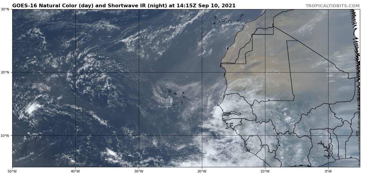
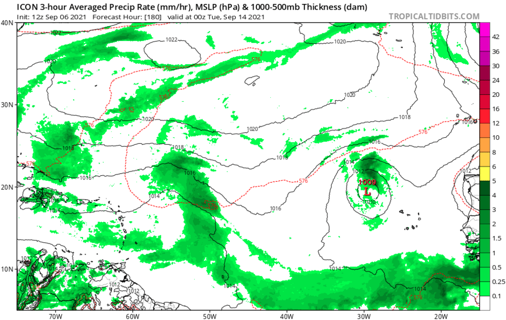
12Z GFS is the 5th run in a row taking this same 9/10-11 emerging AEW into the Caribbean ~9/18 as a result of it staying weak. This wave is what is causing the convection at the Lesser Antilles on the far right in this image:
-
Here we go regarding that same AEW moving off Africa ~9/11: 1. ICON has it stronger and further out than earlier runs as it moves west at the end of the run. It is already pretty far north at 20N, which would suggest a good chance at an early recurve, but keep in mind that the models are jumping around as they try to figure out how strong this AEW will be and where it will track as evidenced by lots of run to run changes 2. UKMET finally has it as it just moved to within its 144 hour range. This track, too, would mean a likely early recurve but note that this has it a TS right off Africa and a near H within 24 hours, both of which could be too strong: NEW TROPICAL CYCLONE FORECAST TO DEVELOP AFTER 120 HOURS FORECAST POSITION AT T+120 : 15.6N 15.7W LEAD CENTRAL MAXIMUM WIND VERIFYING TIME TIME POSITION PRESSURE (MB) SPEED (KNOTS) -------------- ---- -------- ------------- ------------- 1200UTC 11.09.2021 120 15.6N 15.7W 998 39 0000UTC 12.09.2021 132 17.3N 18.7W 992 50 1200UTC 12.09.2021 144 18.9N 20.6W 983 57
-
The 6Z GFS/GEFS and EPS are continuing the idea that the AEW moving offshore Africa 9/10 (GFS) or 9/11 (Euro) (is the same AEW) may very well eventually be something to contend with. The 6Z GFS is the 4th run in a row that gets it near FL ~9/20 as a strong wave. Also, this run suggests there may be another active wave a few days behind it. In addition, note the strong E US ridge being suggested for around that period.
-
The same strong AEW currently over central Africa that the models have for many days been having move off 9/10-11 and becoming a TC almost immediately on a number of Euro and Icon runs is the strongest on the new GFS run that I can recall. Even though it weakens, it is now the 3rd GFS run in a row with a trackable AEW getting into the Caribbean 9/17 and is the most energetic it has been when getting there (strong wave). This once again gets to Cuba/FL Straits/S FL late on 9/20 and tells me once again that this could conceivably threaten the Caribbean ~9/17-20 followed by the CONUS starting ~9/20. Climo says that a scenario like this isn’t at all far-fetched for an AEW moving off ~9/10, especially in La Niña.
-
12Z EPS for same time is not nearly as active as 0Z run: (Edit: But regardless, I'm still keeping a wary eye on the vigorous AEW progged to move off Africa near 9/11. Earlier in this run, you can see a significant SW shift in the mean of this wave along with an increase in the number of members that don't recurve and instead that turn WSW vs the 0Z run.)
.png.ff1f6152961e728070c0425c1eacb965.png)
-
12Z UKMET: 915 mb just 100 miles east of Bermuda! HURRICANE LARRY ANALYSED POSITION : 19.0N 49.5W ATCF IDENTIFIER : AL122021 LEAD CENTRAL MAXIMUM WIND VERIFYING TIME TIME POSITION PRESSURE (MB) SPEED (KNOTS) -------------- ---- -------- ------------- ------------- 1200UTC 05.09.2021 0 19.0N 49.5W 933 106 0000UTC 06.09.2021 12 20.5N 51.4W 942 95 1200UTC 06.09.2021 24 21.7N 53.2W 931 106 0000UTC 07.09.2021 36 22.8N 54.6W 929 110 1200UTC 07.09.2021 48 24.1N 56.3W 919 113 0000UTC 08.09.2021 60 25.8N 57.7W 916 116 1200UTC 08.09.2021 72 27.5N 59.7W 918 118 0000UTC 09.09.2021 84 29.5N 61.7W 918 114 1200UTC 09.09.2021 96 31.9N 63.3W 915 116 0000UTC 10.09.2021 108 35.7N 63.3W 925 105 1200UTC 10.09.2021 120 40.8N 61.2W 929 105 0000UTC 11.09.2021 132 46.5N 55.5W 943 85 1200UTC 11.09.2021 144 52.3N 48.3W 971 46