GaWx
-
Posts
14,719 -
Joined
Content Type
Profiles
Blogs
Forums
American Weather
Media Demo
Store
Gallery
Everything posted by GaWx
-
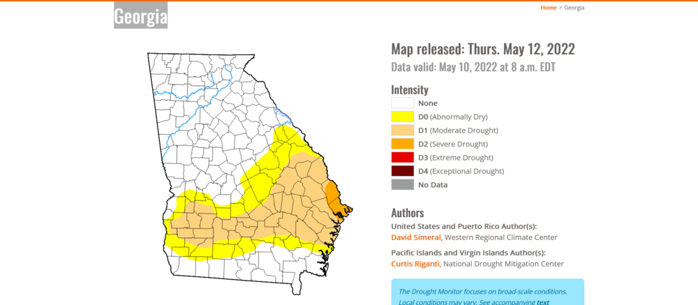
The highs in the area have been 95-96 (96 here), the hottest so far this year. Tomorrow should be similar followed by slightly cooler (88-90 highs) along with daily chances of rain. The drought in this area has worsened since last week as expected with a larger area of D2. I continue to irrigate my lawns at night. Also, GA as a whole has worsened with increased drought coverage:
-
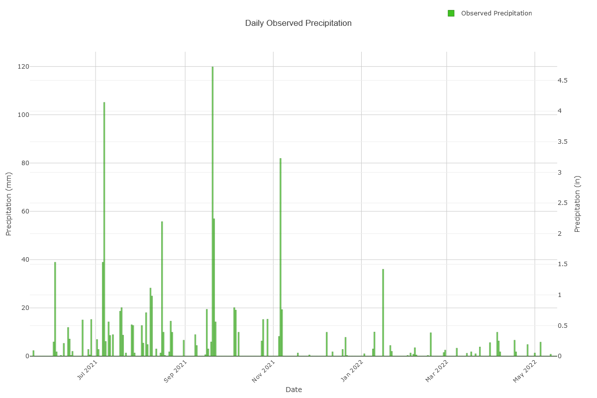
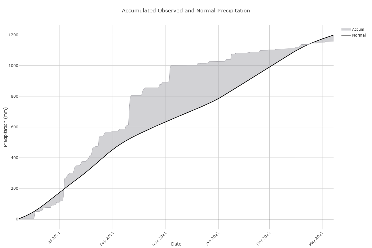
Further to the above, the severe drought (D2) continues here with no rain the next 4 days along with forecasts of near record highs in the middle 90s. Thu and Fri. That means that May 1-20th will have had no more than ~0.3". Since way back on 11/8/21, both KSVN and KSAV have had only one 1"+ rain and that was back on Jan 16th! Normal 1"+ events during that period would number ~5-6. The next chance for rain is this weekend. This time series chart of daily rainfall at KSVN over the last 12 months shows very well the stark contrast between the quite wet period 6-12 months ago and the sudden very dry period since: @gtg947h @Awesomesauce81
-
That's about how it looks down here, too, for this week. Going back 6 months, my area and nearby has been about the driest in the entire SE US thanks largely to La Nina. The closest official station to here, Hunter AAF (KSVN), has had a mere 6.2" of rainfall since 11/14/21 vs a normal of 21" meaning only 30% of normal! This followed an equally wet six month prior period. (see chart below). Our area is now in severe drought, the worst in GA (see below) and at least as bad as any location in the SE including E NC. I've been regularly irrigating at my house lately based on this and because some of the soil feels like concrete. KSAV, the more inland airport station, has also been similar though not as dry with near 45% of normal. May so far has had a mere fraction of an inch so far with no big rains forecasted anytime soon along with middle 90s for highs later this week. This will only make things worse.

-
It has been dry down here, too. For me, this dryness has been the proverbial double edged sword. I've been absolutely loving the good number of days with low dewpoints this spring for comfortable outdoor activities in advance of the almost guaranteed long summer doldrums of heat and humidity. Late last evening was the latest opportunity taken advantage of with a walk in the mid to upper 60s and dewpoints near 50 resulting in no sweating. But on the negative side, soils are dry due to rainfall being only near 50% of normal since 12/1/21 (40% of normal this month) thus necessitating irrigation of the grass just to keep it in halfway decent shape. (Temperatures this meteorological spring have averaged a hair warmer than normal.)
-
Despite the offshore low moving closer to land, there was an additional surge of drier air mid to late this afternoon coming in on steady N to NE winds flowing down E SC coast and into upper SE GA allowing for lower dewpoints into the evening even after the climo time for lowest dewpoints had passed. So, we enjoyed one more very comfy day by mid-May standards. What a nice week it has been to this point! Makes me look forward to October.
-
At 11 AM today at KSAV, the dewpoint had plunged to 34. It typically doesn't get lower than that in May (especially this late) there although it has done so earlier in the month per records: Lowest KSAV May dewpoints back to 1951 I've been able to find (all were between 10 AM and 4 PM): 27 F 5/2/1963 29 F 5/4/1971 30 F 5/8/1989 30 F 5/1/2006 34 F 5/19/1976 34 F 5/10/2022 34 F 5/9/1967 34 F 5/8/1960 35 F 5/27/1961: this one is the most notable for being so late in the month
-
I just took an unusually pleasant 2nd week in May evening walk here with it in the low 60s, a nice NE breeze, and dewpoint near 50. I didn’t sweat at all. It is now 60. Such a nice change from much of last week when it got as hot as 93 with summer-like humidity!
-
Larry Cosgrove forecasts for 2022 tropical numbers, tropical main tracks, and JJAS temperature anomalies:
-
Welcome back spring! After summer-like wx during some of last week, my area is pleasant today and this will last through Thursday it appears with dewpoints mainly in the 50s and 40s til then. Doesn’t get much better than that, especially considering the duration, in the 2nd week of May! But with the good there’s often also the bad. The bad is lack of rainfall as we’ve had only half our normal since 12/1/21! We might get an increase late week due to a retrograding low coming westward from well offshore, but that is highly speculative as amounts may still end up light. Regardless, I’ll enjoy the next 4-5 days!
-
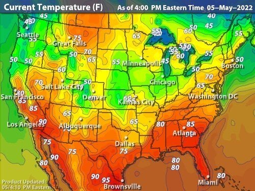
KSAV made it to 92 at 4 PM, hottest by 3 for this year to date. Here's the US map as of 4 PM EDT (20Z) showing the highest temperatures (and heat indices for that matter) in the US outside of some SW desert locations are in the deep SE: (Edit: high was 93, which is two off the record)
-
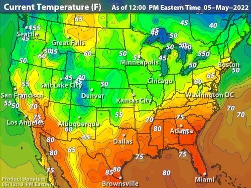
In this area and extending into far S SC and most of the FL peninsula, we're having both the hottest temperatures of the year to date and the hottest in the entire country as of noon EDT. This is being made possible at least in this area by very dry soils resulting from rainfall of only 50% of normal since December. Non-irrigated soils not in the shade are almost as hard as concrete. At noon, it is already 87 at KSAV vs 79 at noon yesterday, when the high was the hottest of the year to date at 89, and vs 83 at noon two days ago when the high was 87. So, 90s are easily on the way with partly sunny skies and hot westerly winds not allowing for modification by the cooler ocean. 850 temps will peak near +18C. Noon EDT temperatures:
-
The airport’s high today was 89, making it the hottest of the year to date. So far, May is coming in significantly warmer than normal. Not good as this is enhancing the dry conditions. Only ~10% of December-April periods were drier than 2021-22.
-
Thank you. Hoping y'all get just the right amount of seabreeze collision related rainfall this summer. That is such a cool phenomenon as it is pretty unique (in the US at least) to the FL peninsula! Based on looking at the records, the good news for my area even with La Nina continuing is that the correlation to dry in summer/early fall is lower than the rest of the year. There have been a nontrivial number of La Nina summers/early falls that were wet although tropical moisture was often an important part of the equation as one might expect. Whereas I don't want any direct tropical hits from anything strong, I'd welcome the moisture associated with either indirect effects or nondamaging systems, which are thankfully much more common than damaging here. Better yet would be plentiful ordinary summertime late day convection. Hopefully Hogtown is spared anything bad this year! With La Nina now likely to continue, we both may have to be on our toes this season as per climo.
-
More on the dryness at KSAV: SAV members may especially find this of interest @gtg947h @Awesomesauce81 Dec 2021 -Apr 2022 rainfall: 8.04" vs normal of 16.17" (So, only 50% of normal). So, we need rain badly! I'm starting to irrigate. - 8th driest on record (back to 1871) - Driest since 1988-9 - The 7 drier ones were in 1988-9, 1984-5, 1937-8, 1926-7, 1910-1, 1897-8, and 1889-90 - Regarding ENSO, 4 of those 7 drier periods were during La Nina (like 2021-2) and other 3 were during cold neutral. - Longterm ENSO climo for this area/SE coast favors dryness during La Nina and wetness during El Nino (wettest ones usually stronger). - The driest El Nino Dec-Apr was 9.62" (1930-1) followed by 9.72" (2006-7). Only 2 El Nino below 10" and none below 9.62". So, I’m hoping for a wet May. But with La Niña continuing, prospects from an ENSO perspective are not good. Model consensus doesn’t show any major relief anytime soon unfortunately.
-
More on the dryness at KSAV: SAV members may especially find this of interest @gtg947h @Awesomesauce81 Dec 2021 -Apr 2022 rainfall: 8.04" vs normal of 16.17" (So, only 50% of normal). So, we need rain badly! I'm starting to irrigate. - 8th driest on record (back to 1871) - Driest since 1988-9 - The 7 drier ones were in 1988-9, 1984-5, 1937-8, 1926-7, 1910-1, 1897-8, and 1889-90 - Regarding ENSO, 4 of those 7 drier periods were during La Nina (like 2021-2) and other 3 were during cold neutral. - Longterm ENSO climo for this area/SE coast favors dryness during La Nina and wetness during El Nino (wettest ones usually stronger). - The driest El Nino Dec-Apr was 9.62" (1930-1) followed by 9.72" (2006-7). Only 2 El Nino below 10" and none below 9.62".
-
April 2022 at KSAV: Mean 66.0 vs 66.6 normal and 64.7 last April Average high 78.7 and average low 53.4 Warmest 88 (vs normal of 89, 88+ since 2006, highest 95 set in 1986, and lowest 78 set in 1901) Coldest 37 (vs normal coldest of 39, highest 52 set in 1941, and lowest 28 set in 2007) Rainfall 0.87" (vs normal of 3.39", 17th driest back to 1871 (meaning nearly 90% have been wetter), driest since 2012
-
Yesterday was still another pleasant day here, which is why I made time to both sit outside and enjoy the late day sunshine and then later take an evening walk.
-
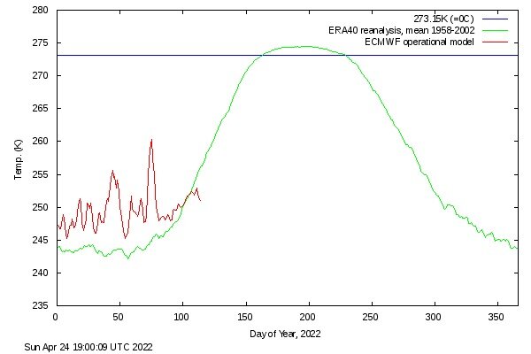
After a long warmer to much warmer than normal period going back through last December (typical of the last decade+), the Arctic has finally cooled to colder than normal over the last week and is now 5C below normal during this period of sharp warming of normals. That is the coldest anomaly for any portion of the year going back at least to 2015. It is also the coldest for April 24th since way back in 1964! No other year on record back to 1958 other than 1964 had it as cold as 251 K (-22 C) this late in the season. After another day or so of continued cold, models have it warming solidly soon after. So, this degree of chill in the Arctic won’t last much longer per models and it will more than likely end up just being a short blip and thus insignificant. Regardless, it will be interesting to follow. Here’s the latest:
-
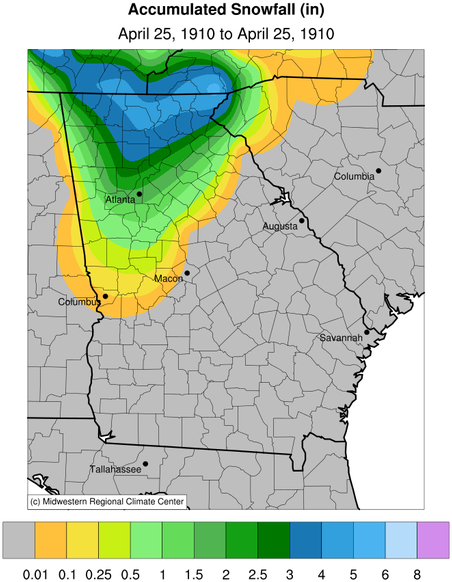
Down here it has averaged near normal to date and that’s where the full month is headed. I’ve enjoyed it. On another subject but still related to April: the most freak Atlanta winter storm imo wasn’t either the 1993 or 1899 blizzard, it wasn’t the icestorm of 1973, it wasn’t snow jam 1982 or snow jam 2014, it wasn’t the near 8” snow of 3/24/1983, it wasn’t the heaviest on record in downtown of 10” of 1940, and it wasn’t either of the 4” sleetstorms of 1979 and 1988. What do I think it was? This one: https://site.extension.uga.edu/climate/2017/04/april-25-1910-snowfall-in-northern-georgia/ Not only was the snowstorm happening that late in April so hard to believe (it was 3 weeks later than the second latest measurable of any amount), the high temperature of only 39 was only the third April day with a high only in the 30s since the late 1800s and nearly 3 weeks later than the second latest! Here’s a map showing the snow: note how far south in GA and AL the measurable got. I’ll add that trace amounts were seen as far south as Americus in SW GA, which is at the latitude of Savannah! There’s no way to know obviously, but it wouldn’t surprise me if this was a once every 500+ year type of occurrence in GA based on how freak this was.
-
It was another fantastic and beautiful spring day here with a high near 70, near full sunshine, dewpoints mainly in the 48-50 range, and breezy conditions off the high 60s Atlantic. This month has had a good number of great days here. Temperatures have averaged close to normal, similar to January. Feb/March were a few degrees warmer than normal. I sat out IMBY these last two evenings. I hope to get in another walk later this evening like I’ve done the last two evenings. Tomorrow should be similarly pleasant with it somewhat warmer but still staying in the 70s.
-
The official stations in this area dropped to 44/45 due to near ideal radiational conditions of near calm winds and clear skies. In contrast, Ft Pulaski on the immediate coast, where winds were NE to E off the upper 60s ocean, didn’t get below 62!
-
Already down into the lower 50s at the two official stations near here and also down at Brunswick. I had an enjoyable walk an hour ago. With dewpoints in the low 40s in my area and near calm winds, some lows are likely going to be in the middle 40s though some clouds may come in later to impede the radiation.
-
Today in this area is one of the last days, if not the last day, til autumn with dewpoints down in the 30s. I plan to take a walk later to take advantage of it. Tonight’s low has a good shot to get below 50, almost certainly one of the last and maybe the last till October. For KSAV, the coldest in May since 2000 has been mainly 48-55.
-
Yesterday was a similarly near perfect day here as well.
-
Very bad luck for you to be there on just about the coldest afternoon of the entire winter! Other than the miserable weather, how was your short visit here? I’ve been to your longtime home of Long Island a number of times (relatives there), but it has been over 30 years. I was in Elmont and took the LIRR from Valley Stream several times to go into “the city”. I went to the Roosevelt Field harness racing track in the 1980s. Went to Lundy’s seafood on LI. Today’s Masters will be much warmer and with much lighter winds vs yesterday.