GaWx
-
Posts
14,722 -
Joined
Content Type
Profiles
Blogs
Forums
American Weather
Media Demo
Store
Gallery
Everything posted by GaWx
-
A big problem to me is the difference between "some" excitement and "too much" excitement. I don't mind "some" excitement as I implied. But we don't get to choose. What will happen will happen. About the only way to know there will not be too much excitement is for it to be boring (say, no hurricane threatening). From my perspective, the problems from "boredom" pale in comparison to the problems from "too much excitement". So, I'm content with boredom (quietness). Or to know, say, that no more than a moderate TS is threatening. But that's just my opinion. Others like you would prefer to take the chance. I respect that you and others feel differently as long as my feelings are also respected. And I respect that people's feelings about this will often change with experiences and circumstances. In my situation, if I didn't have a mainly bedbound family member who has chronic terrible back pain among other things (not to mention the huge responsibility to take care of that family member), I wouldn't feel as worried because everyone could much more easily evacuate. I'm confident that having this situation, alone, would change the perspective of many.
-
I never said nor even implied that wanting translates into making them happen since it of course does nothing of the sort. My point is that not everyone feels the same way about these and I have the right to speak my mind (although I won't do it repeatedly). Doing this during these slow times is obviously a better time to do it than when active
-
I was going to say not to mention the obvious that the last thing the sane amongst us who live not too far from the coast want to happen is a hurricane plowing in and likely causing at a minimum temporary major disruptions to our families' and friends' lives due to the huge inconvenience from having to evacuate (especially for disabled bedbound persons and their caregivers like in my situation..I don't even know how I'd be able to do it), alone, and of course the potential for long lasting power outages and worse yet, damage and even casualties for those who try to ride it out. So, ldub's version of "bad news" is the exact opposite for some of us coastal folks. I just feel it is pointless to repeatedly preach the obvious at a wx forum. But I'm human and will speak my mind on this at times. Your comment gave me a perfect time to do so. This is a reminder that hurricanes are huge life disruptors wherever they hit and are not just a game to see where they will go. So, since a quiet season normally means less chance of these severe disruptions, having a quiet season would actually be great news for some people. I don't mind the nonmajor effects. But as regards major effects, you can put me in the "I'll pass" category every time. Regardless, when I post in the tropical threads, I try to do it in as objective a manner as possible. My goal is to be informative and accurate while not allowing anyone to tell what my desires actually are. If what one desires were to affect one's posts, that would take away from their objectivity and thus their value.
-
This latest area update brings 2022 back up a decent amount vs the average of 2007-21. It is now at +390K vs the prior 15 year average for the date as compared to +320 as of three days ago. Recap of current area vs avg. of last 15 years as of: 6/15/22: +70K 6/16/22: +120K 6/20/22: +240K 6/22/22: +140K 6/29/22: -140K 7/1/22: +70K 7/10/22: +250K 7/12/22: +370K 7/16/22: +330K 7/20/22: +360K 7/23/22: +480K 7/26/22: +460K 7/30/22: +440K 8/7/22: +320K 8/10/22: +390K
-
I just saw this, which was released from the Charleston, SC, WSO about 45 minutes ago and confirms the significant SAL event for here: AREA FORECAST DISCUSSION NATIONAL WEATHER SERVICE CHARLESTON SC 739 PM EDT WED AUG 10 2022 FINALLY, A GOOD AMOUNT OF THE SAHARAN DUST HAS SPREAD OFF THE ATLANTIC INTO COASTAL SC AND GA, RESULTING IN A FAIR AMOUNT OF HAZE THIS AFTERNOON AND TONIGHT. JZI IS REPORTING 5SM IN HAZE AS A RESULT. UNCLEAR HOW LONG THE DUST LAYER WILL BE WITH US. BUT THERE MAY BE OCCASIONAL REDUCED SURFACE VISIBILITIES THROUGH THURSDAY.
-
No rain the last 3 days. But today was pretty unique with what is Saharan Air Layer dust, which barely made it up here. The skies were milky and the sun was filtered along with PC skies. It had the look of smoke or thick summer haze. Interesting stuff! Edit: I just saw this, which was released from the Charleston, SC, WSO about 45 minutes ago, which confirms the pretty rare SAL event for here: AREA FORECAST DISCUSSION NATIONAL WEATHER SERVICE CHARLESTON SC 739 PM EDT WED AUG 10 2022 FINALLY, A GOOD AMOUNT OF THE SAHARAN DUST HAS SPREAD OFF THE ATLANTIC INTO COASTAL SC AND GA, RESULTING IN A FAIR AMOUNT OF HAZE THIS AFTERNOON AND TONIGHT. JZI IS REPORTING 5SM IN HAZE AS A RESULT. UNCLEAR HOW LONG THE DUST LAYER WILL BE WITH US. BUT THERE MAY BE OCCASIONAL REDUCED SURFACE VISIBILITIES THROUGH THURSDAY. Update at 8:10 PM: A strong outflow boundary has just arrived here around sunset from thunderstorms to the west making it suddenly quite windy. We have a shelf cloud of sorts overhead. Will we get rain from this? The radar for now shows only the dry outflow boundary.
-
I just noticed that the sky here in Savannah, GA, is milky and the sun looks filtered. It has the look of smoke or haze. But something about it looks different. Is this possibly from SAL? Anyone know if SAL is currently extending all of the way to the GA and SC coast? If so, this is fascinating as I don't think it gets here all the way here at this intensity more than rarely.
-
And this is despite the 90/30 day SOI of +13/+10. a weak La Nina Nino 3.4 SSTA, and a recently cooled OHC to below normal. OTOH, the Atlantic tropics remain quiet for now....something more akin to El Nino though things can change there in a hurry as it is still early. The climo based main season doesn't even start til near August 20th.
-
Actually, most of those years were barren in the MDR much of the peak season.
-
Yeah, there's no indication that El Niño is coming this fall/winter with a 90 day SOI of +13 and 30 day of +10 along with SSTAs in 3.4 in the weak La Niña range and equatorial OHC having dropped back to cooler than normal. La Niña is still pretty heavily favored though it may peak earlier than average. But La Niña seasons are not all alike to say the least.
-
Third year La Niña climo ftw? Of the 8 analogs, none has had an ACE higher than 135 and that includes the 119 of 2000, which is as good an analog as any to me. Also, July SSTA maps for 2000 and 2022 are fairly similar. Regardless, until we have a better handle on the next 10 days, the door is still wide open to an active (though not hyper imho) season. When I say active, I mean ACE in the general vicinity of 120 and maybe as high as 140ish. We could easily end up with an eastern MDR storm around August 20th (which could end up a dangerous storm that gets far west in the basin per the progged setup as well as history) along with more storms soon afterward. But if we were to get to August 20th with still no new TCs as well as then looking very quiet on models, then a quiet season becomes a significantly higher possibility. It would be amazing if it were to happen in La Niña during this active era! It is fun to see the experts stumped as unpredictability is what keeps long range weather forecasting interesting and a challenge. Keep in mind that only three seasons since 1995 have had fewer than 3 August NS and two of them were El Niño.
-
Invest 97L--10% 2-Day/10% 5-Day Development Odds
GaWx replied to WxWatcher007's topic in Tropical Headquarters
Although the writing is on the wall and the chances for hyper are steadily dropping (I never expected hyper), it is still too early imho to say with confidence it will end up a "total dud". Keep in mind that the very active seasons of 1996, 1998, and 1999 (ACE 166-182) didn't have their first August NS til the 18th or 19th. Actually, 1998 and 1999 both had only their 2nd NS 8/18-19 whereas 2022 has already had three. Also, 1992 didn't have Andrew til August 16th! -
Good point as that seems to be his default, but to fair I know there was one year recently when JB didn't go high risk for the east coast. Personally, whereas I think the east coast should by no means relax especially this early in the season (I'm wary about the danger, myself, but I am most years and also hope for the best), my highest direct hit risk area per analogs and the recent pattern remains the NE GOM, especially around FL. Edit: I just checked and in 2021 he had the upper east coast at well above average risk. The NE got directly hit by 2 TS, which is above the average of 1 or fewer TC hits for the upper US east coast. So, I give him a win there for 2021. More updates: 2020: He had an active season overall but I'm not sure of his impact forecast for the NE US. It appears he did pretty well overall. 2019: he had a somewhat weak season forecasted and it appears he also had a lower impact forecast for the NE US. So, I think this is that recent year I was referring to. ACE turned out to be 132 and Dorian was a beast, but the upper east coast did get off lightly. So, I guess he did ok overall. "From this point of view it looks like a down year in at least the Main Development Region and less of a year farther to the north than last year. The caveat is that in-close systems and warm water feedback will lead to challenges that can make or break the season from an impact perspective. On the high end, if the El Niño isn't impressive we could see activity in line with last year, hence the relatively broad range. I have a feel for where below average intensity of storms relative to normal will be, but the term "scattershot" describes the idea of stronger features away from the Deep Tropics this year." https://www.weatherbell.com/april-hurricane-season-outlook 2018: "WeatherBELL.com is forecasting in between a BELOW to ABOVE average Season with 11-15 named storms, 5-7 hurricanes which 1-3 of those becoming major hurricanes and an Accumulated Cyclone Energy (ACE) of 90-110. WeatherBELL says as far as impact, unlike last year when we plainly had the U.S. in the cross-hairs, this year it looks like the U.S. will be on the western edge of the highest ACE area (50% or more). This will extend between 30°N and 40°N from the U.S. coast to 55°W. If I had to draw it today, the centering of the area of greatest activity would not be like last year. Look for storms to be stronger farther to the north and east than 2017." https://www.trackthetropics.com/hurricane-season-2018-forecasts/
-
Absolutely. Posting style is identical. Also, both have the Norfolk/VA Beach area as home. He or she has amazing longevity for that kind of posting! Like others have said, this person is legendary among trolls. @Torch Tiger Yes, thanks for reminding me. Rainstorm absolutely did have a heart avatar and now I clearly remember it! That was after having the lady with the U.S. flag scarf avatar, which I recall from when jxdama was the name used at WW.
-
This latest area update brings down 2022 a rather significant amount vs the average of 2007-21. It is now at +320K vs the prior 15 year average for the date as compared to +440K as of eight days ago. Recap of current area vs avg. of last 15 years as of: 6/15/22: +70K 6/16/22: +120K 6/20/22: +240K 6/22/22: +140K 6/29/22: -140K 7/1/22: +70K 7/10/22: +250K 7/12/22: +370K 7/16/22: +330K 7/20/22: +360K 7/23/22: +480K 7/26/22: +460K 7/30/22: +440K 8/7/22: +320K
-
Way back in the WW days (~20 years ago), this poster went by the name "jxdama" with what I recall was an avatar of a woman with an American flag scarf. That may have covered 2003, when he/she got blasted by Isabel in the VA Beach/Norfolk area after giving the entire east coast the all clear just a few days before. Thankfully he/she was ok. At some point, he or she began posting as the infamous and everyone's favorite "rainstorm", possibly with the same avatar but I'm not sure. I can't recall if this name change was when Eastern started or before, but I'm guessing it was when Eastern started. This poster used to also post at Storm2k with a different name. @WEATHER53 may remember a lot of this. jx/rs/ldub is "world renowned" to be about as "good" a troll as they come and I admit sometimes makes me laugh because it is often so over the top/silly. The key is to not take the posts too seriously. I bet ldub is often laughing bigtime behind the scenes. By the way, I think he/she really is quite smart and knowledgeable despite the trolling dumb takes. One year rainstorm actually won the Eastern tropical contest! I remember because I ran it. I don't think it was even close. It was hilarious! Rainstorm won it because it was she/he picked pretty bearish and it turned out to be the most bearish season in years.
-
I'm still giving it a 2 in 3 shot at becoming at least a TD. The board may not be as bearish as you think once you ignore the troll.
-
I ended up with a very nice 1.38" today, which brings me to 2.88" mtd. That is quite a bit wetter than normal for the first week of August.
-
At one time, I felt there was a possibility for at least a pause in GW due to the last two very weak sunspot cycles. I was being open-minded. I even allowed enough time for an assumed lag based on the ideas that afternoon highs occur several hours after the daily solar high point and summer's hottest normals occur a month after the summer solstice. However, I pretty much gave up on this idea a few years ago when I saw GW still didn't appear to be slowing to any great degree other than temporary halts due to La Niña. Has there been any significant slowing? We're now nearly 14 years past the late 2008 very weak minimum and nearly 3 years past the 2019 very weak minimum. Even taking into account lag, I now find it hard to believe that there will be a GW pause of a significant length of time due solely to the sun. The sun doesn't seem to be as significant of a factor as I at one time thought was possible.
-
Latest model consensus: - Very good chance for a TC forming in MDR by mid week. Any potential threat to US east coast would be near Aug 18-22 if it were to get close though any one TC forming that far out, even in La Niña in mid Aug, would have a better chance to either recurve safely offshore or a smaller chance to dissipate OTS. The 0Z CFS, which I don't take seriously for tropical details, fwiw actually has this get very close to the east coast Aug 19-22. - A followup E MDR TC quite possibly forming ~Aug 18-20 as the Azores-Bermuda high gets reestablished to the north as per many ensemble members. This would have decent potential to get steered to the western basin based on this setup along with it being La Niña near the end of Aug, an often dangerous time for especially the SE US. - Additional much closer to US geneses mid to late Aug will need to be monitored as alluded to by Ed, especially with the very warm Gulf and off SE coast. - Thus a 3-4 NS Atlantic August is looking like a good possibility, reenforced by Aug total # of NS climo since 1995: 1) only one season with no NS, the strong El Niño of 1997 2) 24 of 27 have had not just 2 but 3+ with only 1997 (super El Niño with 0), 2013 (2), and 2014 (weak El Niño with 2) having fewer than 3 3) Closest ENSO analog (2000) had 4 4) 1996, 1998, and 1999 had none til Aug 18-19 but all ended up with 4 - I never forecasted "hyper" season ACEwise but I continue to expect an active and potentially dangerous season for the US with a guess of 120 ACE. This all appears to still be on track as best as I can possibly tell a week before the climo most active 2 months has even started.
-
Got awoken 9AM by a heavy storm with several hits of nearby CTG. This looks to be a nice hit of rainfall as it is still coming down though it has gotten much lighter here by 9:30 AM. Per radar loop, heavy rain started here near 8:30 AM after a period of lighter rain. It looks like 1"+ here roughly. Other areas of county appear to have gotten much more as a flood advisory has been in effect for the county since 8:44 AM due to only slow movement WNW: FLOOD ADVISORY NATIONAL WEATHER SERVICE CHARLESTON SC 921 AM EDT SUN AUG 7 2022: ..FLOOD ADVISORY REMAINS IN EFFECT UNTIL 1015 AM EDT THIS MORNING * WHAT...FLOODING CAUSED BY EXCESSIVE RAINFALL CONTINUES. * WHERE...A PORTION OF SOUTHEAST GEORGIA, INCLUDING THE FOLLOWING COUNTY, CHATHAM. * WHEN...UNTIL 1015 AM EDT. * IMPACTS...MINOR FLOODING IN LOW-LYING AND POOR DRAINAGE AREAS. WATER OVER ROADWAYS. - AT 918 AM EDT, DOPPLER RADAR INDICATED THUNDERSTORMS WITH TORRENTIAL RAINFALL EXTENDING FROM GARDEN CITY AND DOWNTOWN SAVANNAH SOUTH TO WHITE BLUFF, VERNONBURG AND RIO VISTA. AS MUCH AS 2 TO 3 INCHES OF OF RAIN HAS FALLEN ACROSS PART OF THE SAVANNAH METRO AREA SINCE JUST BEFORE 8 AM. - ADDITIONAL RAINFALL AMOUNTS OF 1 TO 2 INCHES ARE EXPECTED OVER THE AREA. THIS ADDITIONAL RAIN WILL RESULT IN MINOR FLOODING.
-
I had a short period of rain early today, but it resulted in no more than a few hundredths. I'm still near 1.5" mtd.
-
Looks to me like all is going according to how it has looked in recent days with a good chance (I think it is now up to 2/3 chance) for an MDR TC to form in less than a week. That would still be only August 13th or earlier with four NS with the most active two month period climowise still just ahead of then.
-
UK Met Office Forecasts 40C for the First Time
GaWx replied to donsutherland1's topic in Climate Change
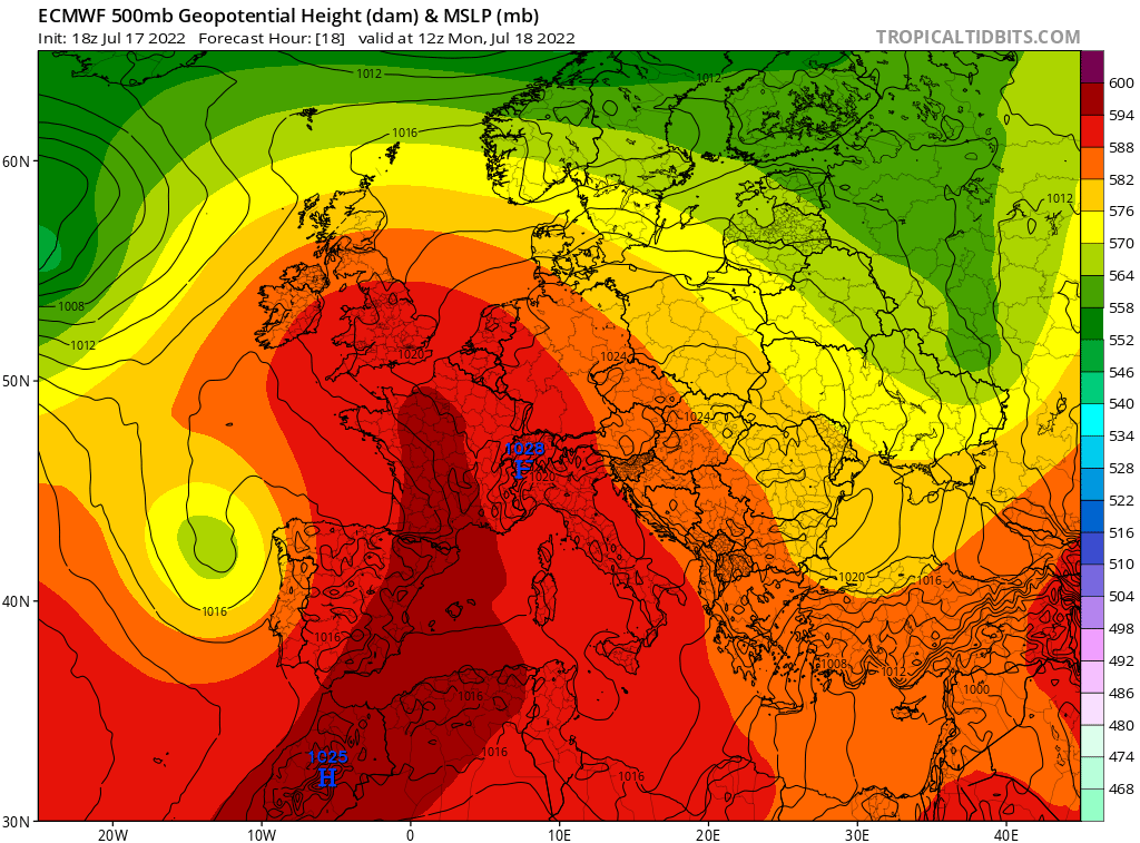
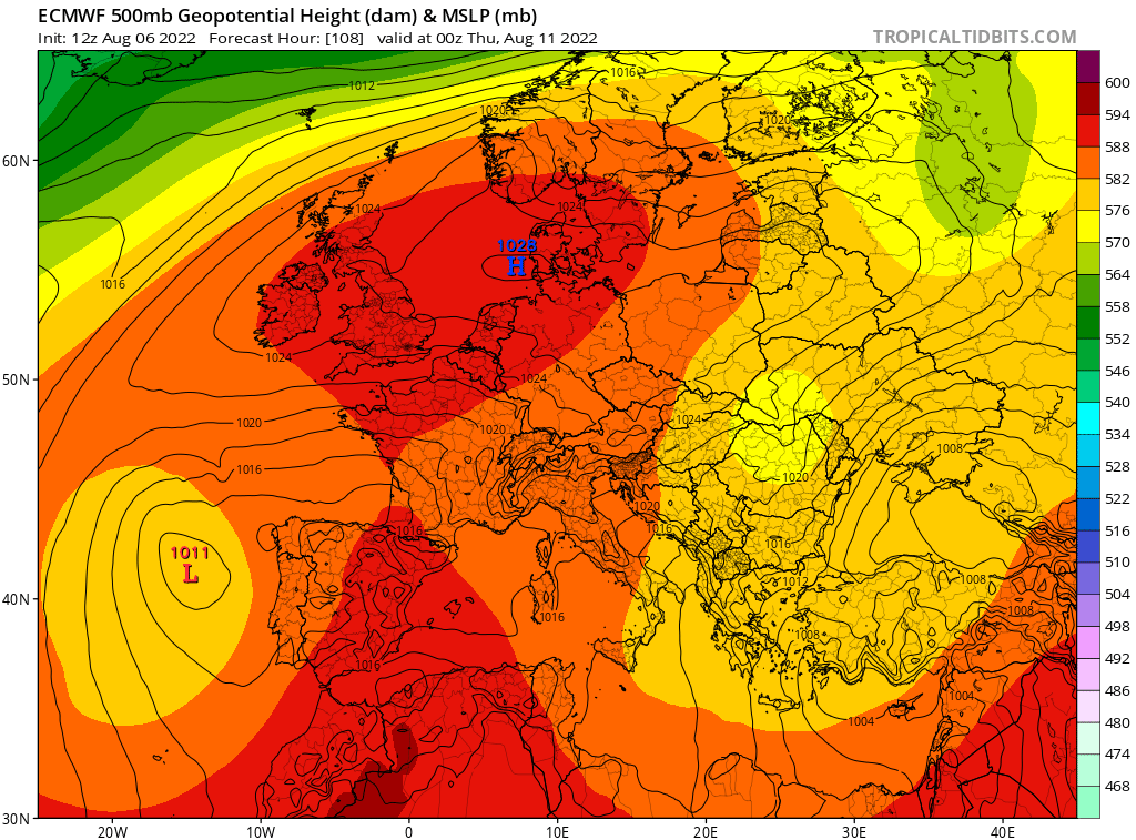
Interesting. However, by this point (5-6 days out), the models were already largely onto the record heat. Also, although the progged 500 mb peak in southern England (591-2 dm) is very similar to the 592 dm peak last month as you implied, the progged E surface winds late next week (due to the sfc high center being to the NE over the N Sea/Denmark along with it ridging westward) vs the SSE sfc winds bringing in the very hot air last month (due to the sfc high center being over Switz. in concert with sfc low to SSW of UK) (see below) are currently limiting S. England progged highs to more ordinary hot as you said (low 90s vs low-mid 100s then). So, I agree with you that it is looking like just a couple of hot days rather than anything approaching last month: 7/18/22 very hot SSE winds from France into S Eng. (along with 592 dm 500 mb peak): 8/11/22 prog: only more ordinary heat due to E winds from Netherlands/Germany into S. Eng. despite 500 mb hts 591-2 dm (nearly as high as 7/18/22):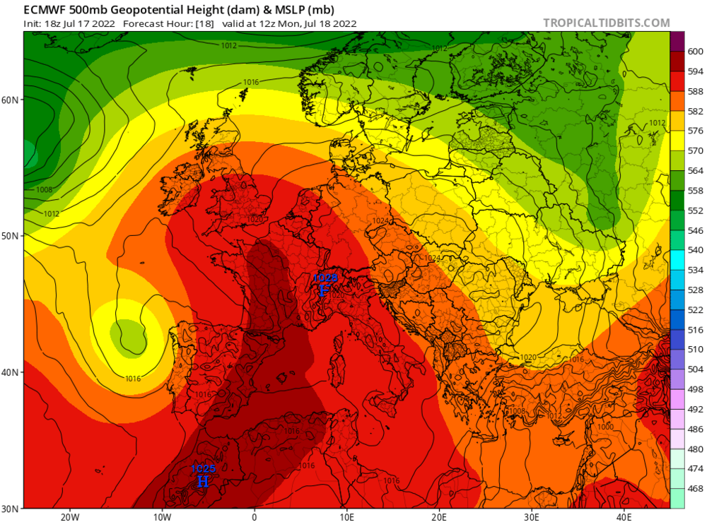

-
The 12Z EPS is much more active with this MDR wave vs the last several EPS runs and is likely the most active run so far.