

GaWx
-
Posts
12,649 -
Joined
Content Type
Profiles
Blogs
Forums
American Weather
Media Demo
Store
Gallery
Posts posted by GaWx
-
-
1 hour ago, snowman19 said:
That is true. Back in Dec. 2001, JB was hemming and hawing that a huge winter was coming because of that -NAO Dec. That was his infamous “vodka cold” winter. Nothing but screaming zonal and semizonal flow off the PAC for months on end courtesy of the relentless high solar onslaught
Do you remember that during that winter (01-02) the prelude to the GFS (the MRF) had a terrible cold bias? It often showed intense and sometimes historic cold in week 2 and especially after day 10. This often mislead JB as he wouldn’t discount the cold bias. I was reading and posting about it at the old WWBB.
-
 1
1
-
-
1 minute ago, CurlyHeadBarrett said:
Wait what the hell is this?
These are at 360 and thus not for the same system.
-
1
-
-
3 minutes ago, bluewave said:
I like the Greenland Blocking Index which is like a combination of the AO and NAO.
And it looks like the sign for more blocking on this GBI is + rather than -.
-
There have now been 3 days in a row of large OISST Nino 3.4 anomaly drops. It has cooled a whopping 0.40C, the fastest since a similar 3 day cooling in early April and is now down to -0.23! The equivalent RONI snapshot is likely near -0.75 to -0.80.

-
2
-
-
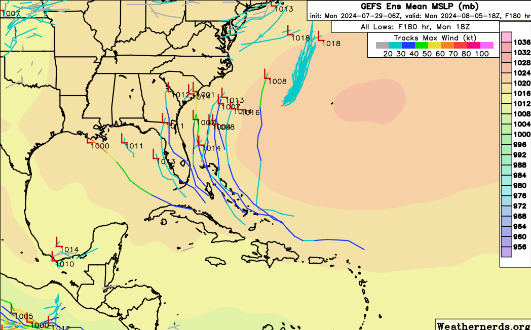
The 12Z EPS is still active and is fairly similar to the 0Z/6Z with some hitting the E coast but more staying just offshore and way less activity in the Gulf vs the Atlantic.
-
1
-
-
21 minutes ago, Normandy said:
I think compared to this board the level of expertise and knowledgeable posters is just severely lacking over there. Additionally the moderators are absolutely childish and squash any and every inkling of disagreement. They treat posters like they are children which is ….. yea not for me. I was a longtime member there and when I found this place I never posted there again
I disagree with the first part as I think both places have a good number of excellent posters. Also, keep in mind that there's overlap of membership as it isn't a pure them vs us situation. When you slam them, you're also slamming some here. But I agree with what I bolded as the moderation there is much stronger.
Regardless, I think it is better to peacefully coexist than to slam each other. This isn't like Dems vs Repubs thank goodness. The tropical wx forum community is bigger than any one BB.
-
1
-
-
29 minutes ago, Normandy said:
That board is a wasteland
I disagree and feel you’re generalizing. I think it is a mix of high and low quality there just like is the case most anywhere. Also, an unknown number of members here are also members there with some actively posting at both. They must be doing something right being that they’ve been around for over 20 years.
-
2
-
-
The 12Z Euro has a TD/TS (as strong as 1004-5 mb) off FL that then moves N and landfalls between Charleston and Georgetown on 8/6.
-
9 minutes ago, Ed, snow and hurricane fan said:
I think his name is Chris Hebert. He is usually pretty good. Only think about S2K is the good posts are buried in not so good posts.
Just like for any BB, the quality of posts there vary heavily depending on the poster. Of course, what’s quality is somewhat subjective. They have a decent number of excellent non-met posters. I like to look at multiple BBs.
-
3
-
-
1) 12Z UKMET: still has a TD though not as strong as the 0Z’s TS that had skimmed the SE FL coast at Palm Beach. The new run delays TCG til it is 50 miles NE of Cape Canaveral. It then moves NE to 150 miles E of Amelia Island, FL:
NEW TROPICAL CYCLONE FORECAST TO DEVELOP AFTER 156 HOURS
FORECAST POSITION AT T+156 : 29.0N 80.1WLEAD CENTRAL MAXIMUM WIND
VERIFYING TIME TIME POSITION PRESSURE (MB) SPEED (KNOTS)
-------------- ---- -------- ------------- -------------
0000UTC 05.08.2024 156 29.0N 80.1W 1008 31
1200UTC 05.08.2024 168 30.6N 79.0W 1008 34————————-
2) 12Z ICON is weaker and further E than 0Z with a weak low near Tampa though it then moves NE to just offshore GA/SC and becomes a 1007 mb TD
3) 12Z GFS has strengthening very slow moving low central Gulf coast that becomes a 1002 mb TS there
4) 12Z CMC is further E and much weaker with just a weak low over SE FL/NW Bahamas. But then it gets stronger as it moves NE offshore NC and becomes a TS moving further OTS.
-
1
-
-
1 hour ago, Ed, snow and hurricane fan said:
A few 6Z GFS ensembles now see the Euro system. About a third of the members.

Ed,
57 (a very experienced and respected tropical pro met in Houston area who tends to be a little conservative for those who don’t know) sounds unusually bullish for him with this just out (didn’t know if you saw this yet):
The real feature is the very large wave just behind the one the NHC mentions. It will be overtaking the first wave and adding its energy to the mix. Neither has much convection now, but that should change near the Bahamas or in the eastern Gulf on Saturday. I think NHC will be bumping chances up to 70-80% by Wednesday, with development just beyond 48 hours by then. I'm thinking that chances are as high as 90% by this weekend. Another working weekend for me. We already have clients requesting conference calls.
-
1
-
-
CDAS has a cold bias but it has recently been trending cooler, consistent with OISST.

-
1
-
-
8 hours ago, Stormchaserchuck1 said:
We also haven't had a true +NAO Winter since 19-20.
2021   12    0.2885
 2022    1    1.0778
 2022    2    1.6830
 2022    3    0.7677

 2023   12    1.9365
 2024    1    0.2060
 2024    2    1.0894
 2024    3   -0.2141
So, 2021-2 DM NAO averaged +1.0.
So, 2023-4 DM NAO averaged +0.8
https://www.cpc.ncep.noaa.gov/products/precip/CWlink/pna/norm.nao.monthly.b5001.current.ascii
-
0Z GFS no TC/just weak Gulf low
0Z CMC/ICON TS into FL panhandle
0Z Euro 1006 mb TD/TS into NC OB
0Z UKMET: TS just off FL E coast that then turns NNE:
NEW TROPICAL CYCLONE FORECAST TO DEVELOP AFTER 132 HOURS
FORECAST POSITION AT T+132 : 24.8N 77.9W
LEAD CENTRAL MAXIMUM WIND
VERIFYING TIME TIME POSITION PRESSURE (MB) SPEED (KNOTS)
-------------- ---- -------- ------------- -------------
1200UTC 03.08.2024 132 24.8N 77.9W 1009 42
0000UTC 04.08.2024 144 26.3N 79.5W 1005 47
1200UTC 04.08.2024 156 28.2N 80.2W 1006 33
0000UTC 05.08.2024 168 30.0N 79.6W 1006 34-
3
-
-
Though not one of top 5 most followed globals, the JMA, which along with the ICON was best with Beryl's track in the W GOM, has a TC for the first time with it in the NW Bahamas moving NNW (TD at 1013 mb). Thus, counting this, that means 3 in GOM (ICON/GFS/CMC) and 3 in SW Atlantic (UKMET/Euro/JMA). So, this run has a TC for the first time on the JMA, UKMET, and ICON.
-
1
-
-
The PDO is falling back down along with it. It’s back down to -2.15 on WCS, which means the NOAA version is probably back to near -3 or below now.

-
2
-
-
How about this for a two day drop of Nino 3.4 anomaly per OISST…it plunged 0.3 C to -0.125C!

-
4
-
-
23 minutes ago, mitchnick said:
The 1 is TAO/TRITON and the other is NOAA/CPC.
https://www.cpc.ncep.noaa.gov/products/precip/CWlink/MJO/enso.shtml
Thanks. But I’m still wondering despite them being from different sources why they’re not even close with one near +1C and the other several degrees below 0C!
-
Just like is the case for the 12Z ICON, the 12Z UKMET is the first run with a TC from the C MDR disturbance (may be due to it just coming in range since TCG isn’t til the end of the run). It is in the NW Bahamas:
NEW TROPICAL CYCLONE FORECAST TO DEVELOP AFTER 168 HOURS
FORECAST POSITION AT T+168 : 25.0N 77.6W
LEAD CENTRAL MAXIMUM WIND
VERIFYING TIME TIME POSITION PRESSURE (MB) SPEED (KNOTS)
-------------- ---- -------- ------------- -------------
1200UTC 04.08.2024 168 25.0N 77.6W 1012 29———————-
Edit: The 12Z GFS is the first GFS with a TC from this since yesterday’s 6Z (hits the FL panhandle). The 12Z CMC again has a TC from this in the E GOM that then hits the FL panhandle with a high end TS.
12Z before Euro: all 4 of the most followed globals have a TC from this with 3 of 4 in Gulf. UKMET is recurving in NW Bahamas.
———
Update: The 12Z Euro is much weaker than prior runs (maybe a TD at most/1007 mb) that goes up the E seaboard from NC.
Despite the 12Z Euro being much weaker, the more reliable ensembles (12Z EPS) are still quite active and still are heavily favoring either near or offshore the US E coast with just a couple of members with a TC in the E GOM.
-
8 minutes ago, so_whats_happening said:
It is trying latest 100-180 subsurface reading shows we are closing in on levels we saw back in April.
.gif.f55edbe6cb173be14c2bbb577f6a329a.gif)
Why is this subsurface animation in top 75-100 meters (solid BN E of 140W) disagreeing so much with the subsurface animation you posted earlier (moderate AN E of 140W)?
-
The 12Z ICON is its first run with a TC from this. At 180 it has a 1005 mb low moving NW in the direction of the central US GOM coast.
-
6 minutes ago, so_whats_happening said:
Just a quick update
June and July TAO data and Hovmollers. You can see that the Easterlies did try to have an impact on the pattern but have since been replaced with weaker trades. Maybe we are shifting the forcing like Bluewave had mentioned in earlier posts as possibility going forward.
.thumb.gif.9473a323232cb235a8d9a225345abf03.gif)

The thing that continues to get my attention the most is the very stubborn moderate warm layer in the top 75-100 meters. It just won’t go away though it would have to (even though this is for only 2N to 2S) for this to end up La Niña per ONI. Actually, usually 2N to 2S has stronger anomalies than 5N to 5S in either El Niño or La Niña since the strongest anomalies in either tend to be nearest the equator.
-
6Z EPS 144 is as active, if not more active, vs the 0Z EPS 150 regarding the C MDR wave.
-
1
-
-
Regarding the NHC TWO disturbance in C MDR:
1. The Euro/EPS and CMC have had a TC on a good number of runs in a row with the CMC hitting the NE Gulf and the Euro having a couple of hundred miles offshore NC TC. But the GFS, ICON, and UKMET have mainly been quiet.2. Just after the least active GEFS run in awhile (the 0Z with only 1 member (3%) having a TC) and despite the 6Z GFS being still another run without a TC from the central MDR wave, the 6Z GEFS with 5 TCs from 31 members (16%) is the most active GEFS to this point. All 5 members landfall in the CONUS (4 E coast, 1 FL Keys and panhandle) with 3 of these 5 landfalling twice. And this is with a still very active EPAC.
-
1
-
.gif.24e34c4b1b26341e5457f09afefaa348.gif)
2024 Atlantic Hurricane Season
in Tropical Headquarters
Posted
For C MDR system:
0Z UKMET: large shift SW and much earlier TCG just N of C Cuba with TS near Key West then turns into FL Big Bend followed by NNE motion into SC/SE GA, NE into coastal SC and then ENE move to offshore CHS; TS nearly the entire track
NEW TROPICAL CYCLONE FORECAST TO DEVELOP AFTER 102 HOURS
FORECAST POSITION AT T+102 : 22.8N 79.2W
LEAD CENTRAL MAXIMUM WIND
VERIFYING TIME TIME POSITION PRESSURE (MB) SPEED (KNOTS)
-------------- ---- -------- ------------- -------------
1200UTC 03.08.2024 108 23.3N 79.9W 1007 37
0000UTC 04.08.2024 120 24.8N 81.8W 1004 39
1200UTC 04.08.2024 132 26.9N 83.2W 1003 37
0000UTC 05.08.2024 144 28.9N 83.0W 1003 33
1200UTC 05.08.2024 156 31.4N 82.5W 1008 36
0000UTC 06.08.2024 168 32.8N 79.4W 1006 35