

TheMainer
-
Posts
224 -
Joined
-
Last visited
Content Type
Profiles
Blogs
Forums
American Weather
Media Demo
Store
Gallery
Everything posted by TheMainer
-
December 2024 - Best look to an early December pattern in many a year!
TheMainer replied to FXWX's topic in New England
Went out packing trails and clearing blow downs today, surprising amount of snow north and west of town, especially compared to my house 8 miles south with only a crusty 3 inches on the ground. Hoping for minimal rain Tuesday and some snow Thursday and into Christmas week. Another 8 Inches and we can make our first pass with the groomer -
The 3 inches of snow left in the yard definitely looks more like April than December,but happy we retained some snow. Will make an impenetrable base for snowmobile season as I'm hoping groomer shed still has 5 or 6 inches
-
Sprinkling lightly here at about 35 degrees, snow pack has been resilient so far with the freezing rain layer from earlier, now hoping we get the dry slot of the century and we might actually have a couple inches when I wake up tomorrow still, but I know that's just a pipe dream... Just don't flood like last year and I'll take that as a win currently.
-
December 2024 - Best look to an early December pattern in many a year!
TheMainer replied to FXWX's topic in New England
Taking the wife to NYC for a 3 day trip the 21st through 23rd, so definitely lock in a HECS from NYC to Bangor Maine that weekend.... -
December 2024 - Best look to an early December pattern in many a year!
TheMainer replied to FXWX's topic in New England
Another 1.5" here for ~17" for the season so far. Let's avoid the worst of the winds here and give it to the coastal guys that want it and we'll begin again on Friday building towards winter again. -
December 2024 - Best look to an early December pattern in many a year!
TheMainer replied to FXWX's topic in New England
If you love the outdoors and don't mind every business within an hour closing at 8pm (besides the handful of bars) it's a great place to live. I get to WFH 4 days a week and drive down by dryslots house 1 day per week to work in office about 2 hours away, but well worth it. I lived down there for 10 years and never really enjoyed it after growing up here. -
December 2024 - Best look to an early December pattern in many a year!
TheMainer replied to FXWX's topic in New England
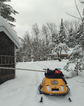
After the 6 inches today the old man and I shoveled all the roofs up to deer camp and my grandmother's house. Closing in on 2 feet that'll all end up in the river by Wednesday night. At least I got to take my 98 tundra camp sled for a 2 mile ride up to camp, almost as much fun as my 2024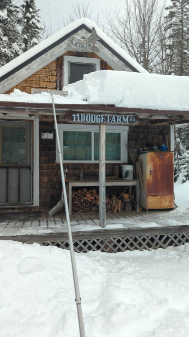
-
December 2024 - Best look to an early December pattern in many a year!
TheMainer replied to FXWX's topic in New England
Close to 6 inches out of this little clipper, another 0,4 inches of QPF to help flood the river... -
December 2024 - Best look to an early December pattern in many a year!
TheMainer replied to FXWX's topic in New England
Don't know why I even tried to hope this wouldn't happen again. Hopefully all the cables holding our bridges hold again We maintain categorical PoPs with rain in this timeframe for the 5th straight forecast cycle as confidence continues to increase in this event. Moisture transport into the area is anomalous and on a par with storms in Dec 2023. A powerful low level jet will draw deep moisture northward from the Gulf of Mexico Wednesday into Wednesday night. -
December 2024 - Best look to an early December pattern in many a year!
TheMainer replied to FXWX's topic in New England
Less snow to melt in the rain, last thing we need to do is replace another 40 snowmobile bridges 2 years in a row! For the rain, while the area has been in a drought, the frozen ground will produce quick runoff and threaten to break up existing river ice. With QPF measured in inches, hydro concerns cannot be ignored. -
December 2024 - Best look to an early December pattern in many a year!
TheMainer replied to FXWX's topic in New England
Oh well, let's get the misery now and get back to winter before Christmas hopefully. Every God damn year except for 2018 this happens From the NWS: As the trough sharpens and pushes east on Wednesday, a more coherent frontal system forms over the Appalachians. This frontal system, in combination with subtropical ridging in the open Atlantic, works to push a surge of moisture and warmer air north into our area Wednesday into Wednesday night. This has the potential to bring rain, possibly heavy, lots of melting, and possibly some hydrological concerns Wednesday night into Thursday. -
December 2024 - Best look to an early December pattern in many a year!
TheMainer replied to FXWX's topic in New England
That look like we'll be screwed even up here? We're debating bringing the groomer out Sunday, right now plan is sleds and saws to pack and open stuff -
5.5" here now, NWS says one more band this afternoon could drop another inch all the SNE guys have been getting. 8+ at the groomer garage, within 10 years we'll build on my lot at the lake so I can enjoy the extra 400' of elevation!
-
December 2024 - Best look to an early December pattern in many a year!
TheMainer replied to FXWX's topic in New England
Hoping we get away with just some 40's and a couple rain showers at most up here, winter is well on its way currently and would stink to lose that progress -
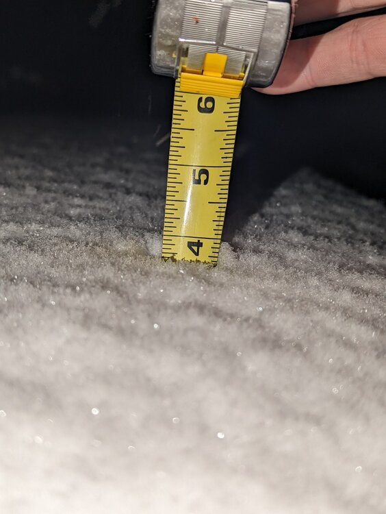
3.5" of fairly wet snow when I took the trash out and started the wood stove at 400'. Still snowing steadily and looks like some decent bands headed our way on the radar. Groomer garage had 6" at 5am at 800', likely will get close to 8 if I had to guess.
-
Still hopefully getting around 6 inches, enough to get the sleds out and start cutting and packing trails on Sunday after muzzleloader ends.
-
31 here, probably peaked and will head the other way. Just hoping colder doesn't mean more progressive and we lose our on 6+ up here.
-
December 2024 - Best look to an early December pattern in many a year!
TheMainer replied to FXWX's topic in New England
Our average high temp drops below freezing 12/13 so we'll be fine, hopefully not as warm as everyone is saying for the whole area, but is what it is. If we can avoid the Grinch I'll do a little jig out in the yard -
-
Hoping we hold steady with this up here, after last years poor snowmobile season businesses are hurting. URGENT - WINTER WEATHER MESSAGE National Weather Service Caribou ME 325 AM EST Tue Dec 3 2024 MEZ001-002-004>006-010-031-031630- /O.NEW.KCAR.WS.A.0006.241205T0000Z-241206T0600Z/ Northwest Aroostook-Northeast Aroostook-Northern Piscataquis- Northern Penobscot-Southeast Aroostook-Central Piscataquis- Southern Piscataquis- Including the cities of Guilford, Presque Isle, Fort Kent, Caribou, Dover-Foxcroft, Madawaska, Medway, Milo, Baxter St Park, Chamberlain Lake, Van Buren, Greenville, Blanchard, Mount Katahdin, Patten, Churchill Dam, East Millinocket, Millinocket, Clayton Lake, Mars Hill, Allagash, Monson, Ashland, Smyrna Mills, Houlton, Frenchville, Sherman, and Hodgdon 325 AM EST Tue Dec 3 2024 ...WINTER STORM WATCH IN EFFECT FROM WEDNESDAY EVENING THROUGH LATE THURSDAY NIGHT... * WHAT...Heavy snow possible. Total snow accumulations between 6 and 9 inches possible. Winds could gust as high as 40 mph. * WHERE...Portions of Central Highlands, Far Eastern, Far Northern, and North Woods Maine * WHEN...From Wednesday evening through late Thursday night. * IMPACTS...Travel could be very difficult. The hazardous conditions could impact the Thursday morning and evening commutes. Strong winds could cause extensive damage to trees and power lines and possibly reduce visibility due to blowing snow. PRECAUTIONARY/PREPAREDNESS ACTIONS... A Winter Storm Watch means there is potential for significant snow, sleet or ice accumulations that may impact travel. Continue to monitor the latest forecasts. && $$ AStrauser
-
Fingers crossed!
-
We ended up with a settled 10 inches from the first storm from the groomer barn north, another 6 inches and we'd be able to make a pass Sunday after muzzleloader ends. Heading south towards my house maybe a compacted 3 inches left. Amazing what 400 feet of elevation will do.
-
Turkey Day Birch Bender Snow Storm/Observation Thread 11/28/-11/29
TheMainer replied to dryslot's topic in New England
Probably about 3.5" inches here so far at 400', was over to the in laws til 2:30 and they were all rain, drove 45 mins back west for my family's festivities and it was snowing since noon, now big puffy cotton balls, roads are slick as shit, nice wintery appeal. Seems like most of the snow is gonna happen tonight for us, will be curious what I wake up to -
Turkey Day Birch Bender Snow Storm/Observation Thread 11/28/-11/29
TheMainer replied to dryslot's topic in New England
Well, definitely changing the oil in my generator tomorrow morning, haha. God damnit, we just cut all the blow downs out of trails, looks like we'll start again on Sunday.... -
Turkey Day Birch Bender Snow Storm/Observation Thread 11/28/-11/29
TheMainer replied to dryslot's topic in New England
CAR with no WSW yet, will be curious to see what they think, probably an advisory instead


