

Buddy1987
-
Posts
4,178 -
Joined
-
Last visited
Content Type
Profiles
Blogs
Forums
American Weather
Media Demo
Store
Gallery
Everything posted by Buddy1987
-
What about the stj and subsequent tapping of gulf moisture? The gulf looks to be wide open on this one. I would think the northern shield would end up looking much better come verification time, even if it were suppressed city.
-
I’m on my phone when I view these things thus why I can’t.
-
@168 Low is east of CHS
-
Euro def has some serious cold building in at 144 from the NE, with a 1039 HP over Iowa. This storm has been intriguing to track at the minimum.
-
FV3 and Euro are not that far off from one another with LP placement at 144. Euro just a tick faster.
-
I think you’re gonna be just fine as well man, especially with that HP anchored right to our north. Gonna have good antecedent conditions for this one.
-
@Jonathan I gotta agree with @WidreMann on that one it really isn’t that hostil meteorologically speaking. You have a low that traverses across the country in the southern stream with confluence up top basically dictating how far north and south this thing goes. The models have moved away from the miller b scenario and are honing in on a miller a scenario in its place. The trend over the next few days is to see if the confluence is modeled too weak or too strong. I am beginning to get that sense as others have alluded to that regardless a good majority are going to get a healthy front end thump, which I’m more than ok with, as that is when we have our best storms. Comes in like a darn wall.
-
Canadian if no one posted is a classic WNC/VA snowstorm track, pending 850s. Seems to me we are trending more toward a miller a with the models.
-
Careful man don’t be unrealistic and get your hopes up or speak truth on what the models are showing around here. Might be taken out of context. Anywho, 12z gfs is a beast of a storm for most the forum. Will leave my analysis short and sweet.
-
March 12/13/14 Blizzard/Winter Storm/WWA etc
Buddy1987 replied to Bostonseminole's topic in New England
Looks like another band of light snow trying to build once again over the hills. Depending on what it does, you could potentially add to the total. -
March 12/13/14 Blizzard/Winter Storm/WWA etc
Buddy1987 replied to Bostonseminole's topic in New England
Days and days of snow for Downeast Maine. What a radar shot. -
March 12/13/14 Blizzard/Winter Storm/WWA etc
Buddy1987 replied to Bostonseminole's topic in New England
I am amazed by that band over Windham county. Unreal there the last couple hours. Looking forward to reports out of the county later. -
March 12/13/14 Blizzard/Winter Storm/WWA etc
Buddy1987 replied to Bostonseminole's topic in New England
Post it to youtube and then copy the link and it'll work. Had the same problem yesterday myself. @RUNNAWAYICEBERG bro it has got to be dumping over you right now. Nexrad is bright yellow in and around you guys. -
March 12/13/14 Blizzard/Winter Storm/WWA etc
Buddy1987 replied to Bostonseminole's topic in New England
That band stretching from Lindenhurst Long Island to southeastern Litchfield County, CT looks legitimate. The band stretching from eastern Long Island into southeastern CT has also gained traction and is moving westward at a quicker pace. Gonna be interesting to see where they set up shop for awhile. Meanwhile, to the east of all this looks like complete domination. Unreal snowbands pivoting off the Atlantic. -
March 12/13/14 Blizzard/Winter Storm/WWA etc
Buddy1987 replied to Bostonseminole's topic in New England
The central CT subsidence looks to be slowly fading away, viewing the wunderground Nexrad radar. The band also looks to be building ever so slightly to the east as well. Should be good times for the CT peeps here shortly. -
March 12/13/14 Blizzard/Winter Storm/WWA etc
Buddy1987 replied to Bostonseminole's topic in New England
I didn't realize last storm you missed the good band. We ended up with 18'' in Thomaston on that one. Hopefully she pivots or back builds for you in a little. -
The December to Remember 7th-8th blue turd winter threat thread.
Buddy1987 replied to lilj4425's topic in Southeastern States
Good thing is I am closer to that way. Im off exit 137 on 81 if you are familiar. -
The December to Remember 7th-8th blue turd winter threat thread.
Buddy1987 replied to lilj4425's topic in Southeastern States
We are effed up this way. Dry air for the win! Ugh Edit: And then the gods heard me and the first flakes started to fly! -
The December to Remember 7th-8th blue turd winter threat thread.
Buddy1987 replied to lilj4425's topic in Southeastern States
Precip filling in nicely over Eastern TN. Definitely good for everyone on the forum. Atmosphere juiced up! -
The December to Remember 7th-8th blue turd winter threat thread.
Buddy1987 replied to lilj4425's topic in Southeastern States
Yup!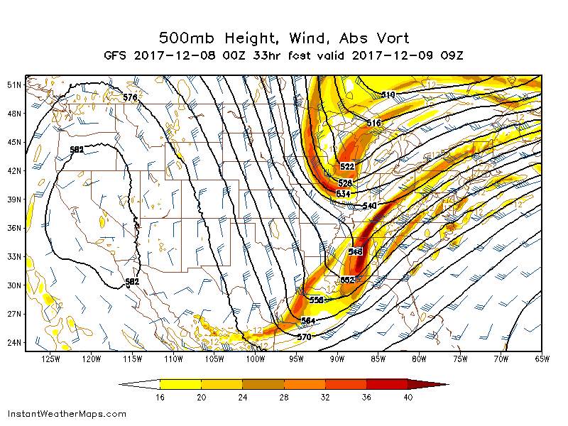
-
The December to Remember 7th-8th blue turd winter threat thread.
Buddy1987 replied to lilj4425's topic in Southeastern States
Wncsnow #crushedson! -
The December to Remember 7th-8th blue turd winter threat thread.
Buddy1987 replied to lilj4425's topic in Southeastern States
5h is a thing of beauty at 33 on the gfs. -
The December to Remember 7th-8th blue turd winter threat thread.
Buddy1987 replied to lilj4425's topic in Southeastern States
Gfs qpf looks extra healthy at 18 already. .25” showing up in foothills/mts of NC and SC -
The December to Remember 7th-8th blue turd winter threat thread.
Buddy1987 replied to lilj4425's topic in Southeastern States
Yes. That’s why it is somewhat confusing when you have the physics I mentioned above that it wouldn’t paint a better picture than what it is portraying precip wise. A lot of things are coming together and then to throw gulf moisture in there.. I think the 18z gfs did a great job portraying what reality might look like. -
The December to Remember 7th-8th blue turd winter threat thread.
Buddy1987 replied to lilj4425's topic in Southeastern States
I think you have the right idea my man. You have to think we are in the right rear quadrant in this instance, which is going to lead to some pretty decent ascent and lift for moisture to get rung out. Nam is too dry imo at 0z. Not wishcasting but from a physics standpoint the hires Nam is much more “real” looking.

