Buddy1987
-
Posts
4,178 -
Joined
-
Last visited
Content Type
Profiles
Blogs
Forums
American Weather
Media Demo
Store
Gallery
Everything posted by Buddy1987
-
GOOD CHANCE OF 1ST LIGHT SNOW EVENT VA / nw NC/ MD DEL MONDAY DEC 7
Buddy1987 replied to DTWXRISK's topic in Mid Atlantic
Oof yea GFS is DOA for 12z. I would love to use the excuse of convective feedback but that is probably pulling at straws at this point. -
GOOD CHANCE OF 1ST LIGHT SNOW EVENT VA / nw NC/ MD DEL MONDAY DEC 7
Buddy1987 replied to DTWXRISK's topic in Mid Atlantic
I’ll honestly believe it when I see it even down in ROA for my backyard. -
Do it!! I’m not sure I ended the season above 2” total so let’s bring some good juju early on.
-
12/9/2018 last time I had something decent early around here
-
How much would it take for everyone to have a meh rest of the year if Monday came to fruition and over performed? Be honest
-
Man that’s a nasty looking band over FLL and Boca up into West Palm
-
This has my attention this go around, as my parents literally just relocated from Charleston SC to Naples within the past 3 weeks. Curious to get everyone’s thoughts as to what, if any disruption Cuba does to this thing before it re-emerges back into the Atlantic/Gulf. Me thinks we’re in for a surprise (just gut feeling) nothing scientific or meteorologically speaking.
-
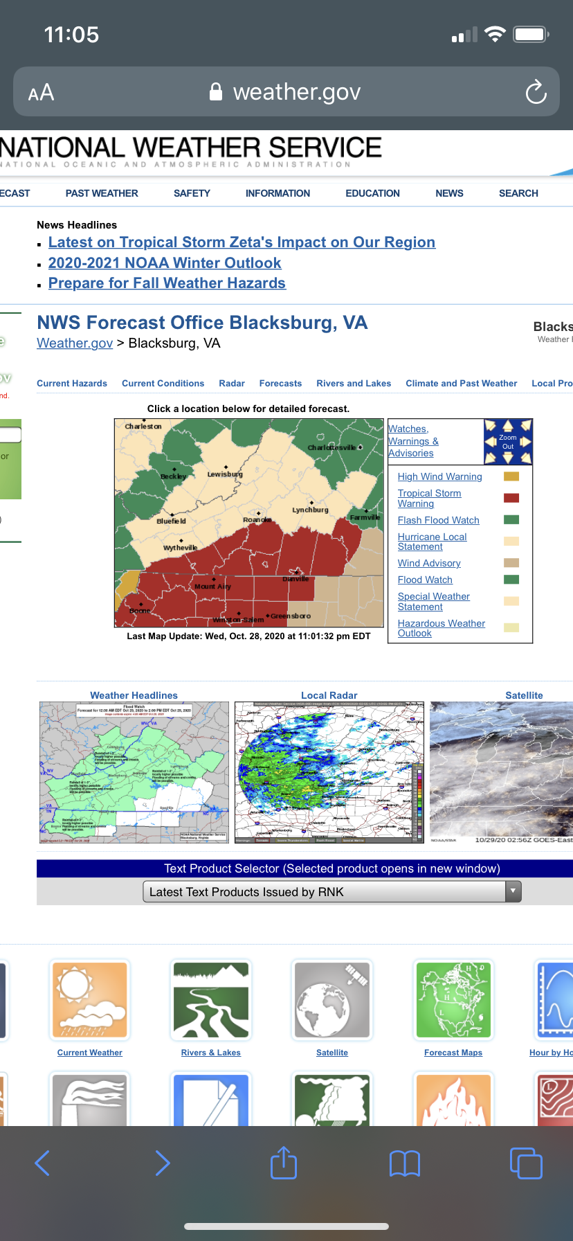
10+ years of living in Roanoke can’t say I ever recall seeing Tropical Storm warnings and local hurricane statement products issued. Pretty wild. Gusts to 47 tomorrow for my area.
-
@CAPE @nj2va @yoda if you guys could choose would you prefer a front loaded or back loaded winter if given the opportunity to pick?
-
I like the positivity!
-
Hey guys! Two questions. 1. Anyone care to guess what some of those cumulonimbi tops are in this ring wrapping around the center? 2. Anyone with aviation knowledge know what the p3 and other weather aircraft are programmed with or what is installed in the cone of the planes to avoid direct lightning strikes or how it is “safe” and I use that word laughing flying into something like this?
-
My sister is in Summerville and is saying there are sirens everywhere. Luckily they are ok
-
Debris field on the super res velocity on radar scope is unreal. Can’t get a hold of my sister either as it’s 15 miles from them now ugh..
-
Man starting to get worried for my sister who lives in Summerville. No more than 30 miles from Walterboro to her house and that’s not on a direct line. This thing is incredible on the super res velocity.
-
2020 Mid-Atlantic Severe Weather - General Thread
Buddy1987 replied to Kmlwx's topic in Mid Atlantic
Would someone be kind enough to post the NAM and GFS or any type of model output that shows for VA DC etc as to what squall line will look like when it blows through tomorrow morning? Or is there a site I can access that would show this in a better manner than instant weather maps. *I have Pivotal weather as well. That seems to be a bit better wrt svr parameters they offer. -
2020 Mid-Atlantic Severe Weather - General Thread
Buddy1987 replied to Kmlwx's topic in Mid Atlantic
The verbiage on the Day 2 synopsis is concerning considering they go with possible strong tornadoes and an outbreak and mention southern va and areas around. Not sure I’ve ever seen that in the 10 years I’ve lived here myself except maybe one time but the ingredients never came together. -
More I look now more the parameters are the highest I’ve seen in some time for 0-1 helicity being 450-500 on the NAM and winds ripping right above the surface over 60 knots based on the GFS. Temps get close to 70. Question for the pros would be are we looking more at high shear low instability environment or do we have a chance to build up anything before everything comes together.
-
Kind of just starting to acclimate myself to this threat, as Blacksburg has somewhat kept it tepid. Do the ingredients get as far north as VA or is it more NC,SC and the Deep South on this one?
-
Lol honestly if you got 10 and I got 4 I def wouldn't complain one bit the way this winter has gone. Let's see what Icon has to say here.
-
Question is though is it typical NAM bias to over amp these things?
-
Kinda playing catchup here but really only thing I40 north in my opinion can hope for is either some over amplification or some southeast aided flow. Dry air is going to be a contender with a 1043 parked to the west of us.
-
Anybody have the 18z Canadian? There is one correct?
-
Mid January/Mid February Medium/Long Range Discussion
Buddy1987 replied to WinterWxLuvr's topic in Mid Atlantic
I'm in JI camp. Give me the heavier rates and marginal cold and I'll take my chances at least out this way for some heavy meatballs. -
Mid January/Mid February Medium/Long Range Discussion
Buddy1987 replied to WinterWxLuvr's topic in Mid Atlantic
Good pickup JI. 540 line looks to stay se of 81 corridor at minimum. Problem is GGEM has low much further east of MYR than GFS at around the same juncture. Something to keep an eye on. -
Mid January/Mid February Medium/Long Range Discussion
Buddy1987 replied to WinterWxLuvr's topic in Mid Atlantic
Cant get a better track than that in late Jan from MYR to east of RIC. Depressing with temps