Buddy1987
-
Posts
4,511 -
Joined
-
Last visited
Content Type
Profiles
Blogs
Forums
American Weather
Media Demo
Store
Gallery
Everything posted by Buddy1987
-
I’m going on vacation to Downeast Maine beginning 1/19 and I see at the end of the GFS run it has a system diving into the Plains. This has been a period that I’ve been watching closely, just because of travel worries and it has consistently for a good month plus shown the 19th-21st as a potential from our area northward. Another thing to watch down the line here.
-
Yea down in ROA. Im ok with the RGEM/GFS runs at 0z. 2-4/3-6 ordeal wouldn’t hear a complaint from me.
-
Yea I was just more or less basing it on the confluence over the Midwest and the slight amplification of the precip shield that developed over northwestern MS (just to add my two cents )
-
GFS going to be north?? Confluence looks less potent at 60
-
I agree my friend! Looks awesome
-
This is first I’m following it in earnest. Can anyone explain as to what is enhancing a n/s clipper from what I’m gathering?
-
Well.. at least temps will be a little more forgiving with this system, after a complete dud down this way with todays storm. We maybe got 2” and that was on top of elevated surfaces. Better than nothing of course but nonetheless disappointing.
-
2021-2022 Fall/Winter Mountains Thread
Buddy1987 replied to BlueRidgeFolklore's topic in Southeastern States
Rather uneventful for my direct area as Disc alluded to. Last hour really saved us as it absolutely ripped ginormous dendrites. Got about 2” on the car. Roads/Driveway just wet. -
2021-2022 Fall/Winter Mountains Thread
Buddy1987 replied to BlueRidgeFolklore's topic in Southeastern States
Roads caving about 5 miles north of me. Just started ripping fatties here -
2021-2022 Fall/Winter Mountains Thread
Buddy1987 replied to BlueRidgeFolklore's topic in Southeastern States
Big dud so far up in ROA. No accumulation although this was about the time it was supposed to start/turn over. Temp down to 33.8 dp 31 -
2021-2022 Fall/Winter Mountains Thread
Buddy1987 replied to BlueRidgeFolklore's topic in Southeastern States
Welp that deflated the tire LOL. Both know at this point sooner we can flip the better chance we have of higher totals. Sometimes I’ve been happily surprised, other times I’ve woken up to see 37 and rain so time will tell. Appreciate the thorough analysis. -
2021-2022 Fall/Winter Mountains Thread
Buddy1987 replied to BlueRidgeFolklore's topic in Southeastern States
GOOD LORD! Where is @Disc 7.1” in 3 hours for Blacksburg, 5.7” out my way.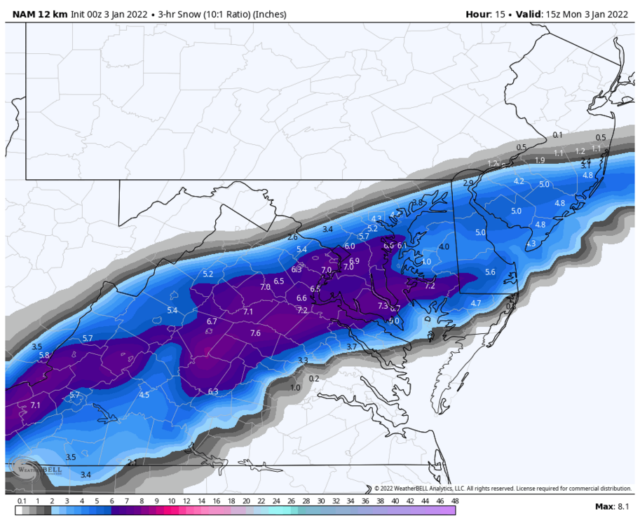
-
2021-2022 Fall/Winter Mountains Thread
Buddy1987 replied to BlueRidgeFolklore's topic in Southeastern States
The upslope SE flow with the negative tilt commencing is just going to pile up massive amounts of pwats right against the mountains. Storms like these is why we track. Only thing literally missing is a slower system -
2021-2022 Fall/Winter Mountains Thread
Buddy1987 replied to BlueRidgeFolklore's topic in Southeastern States
Absolute classic snow bomb with the low traversing right through central NC, at least for this neck of the woods. This same type of setup produced 2ft of snow up this way back in 2011. -
2021-2022 Fall/Winter Mountains Thread
Buddy1987 replied to BlueRidgeFolklore's topic in Southeastern States
-
2021-2022 Fall/Winter Mountains Thread
Buddy1987 replied to BlueRidgeFolklore's topic in Southeastern States
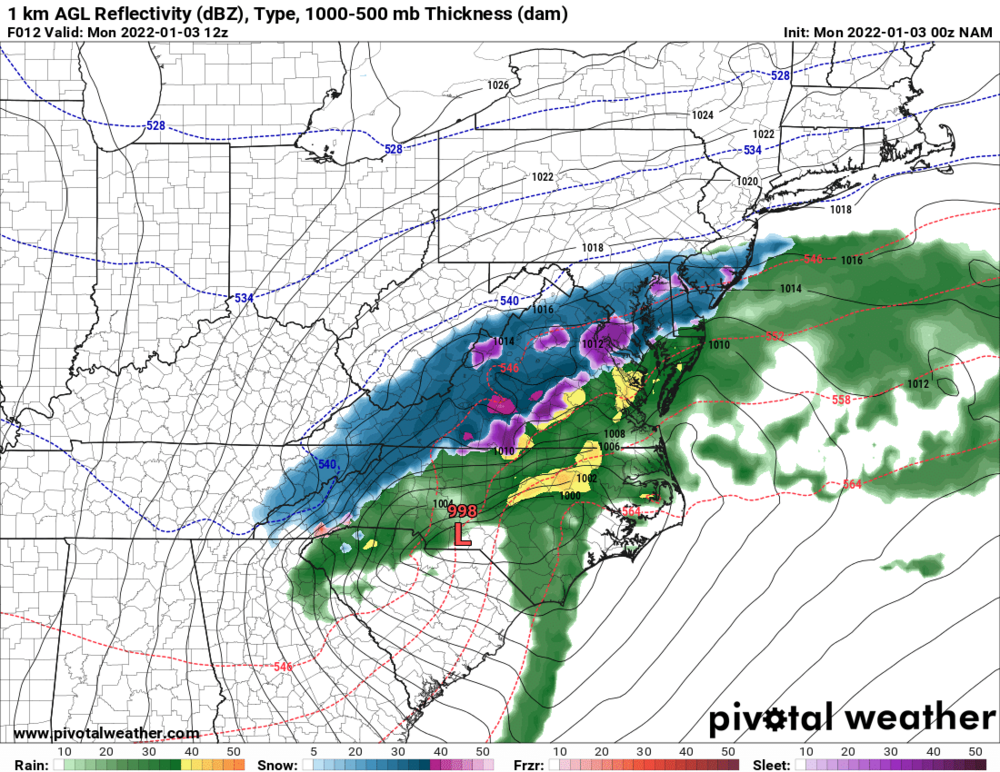
Man oh man that deform band from like hour 7 until 14, specifically on 0z NAM 12k and then continuing on north/northwest is going to mean serious business from Smokies into western NC mountains and up into the SWVA empire and then onto central VA. The rates are just going to be silly. Every model has some form or semblance of this. -
Temp dropping quickly. Down 9 degrees from no more than 90 min ago. 54.1/50.4
-
@psuhoffmanjust emailed you for zoom link.
-
2021-2022 Fall/Winter Mountains Thread
Buddy1987 replied to BlueRidgeFolklore's topic in Southeastern States
I didn’t see personally but correct me if I’m wrong that’s a sign of weakening, which is good for our next system and the amplification process etc. -
2021-2022 Fall/Winter Mountains Thread
Buddy1987 replied to BlueRidgeFolklore's topic in Southeastern States
Holy sh*t! It nearly tripled the amount up this way from 5.1 to that! Dang and ps I didn’t want to jinx the TS word but with dynamics like this it’s full send it -
Waking up to WSW feeling like…

-
2021-2022 Fall/Winter Mountains Thread
Buddy1987 replied to BlueRidgeFolklore's topic in Southeastern States
Canadian having issues with thermal setup on 850/precip map. There is going to be some insane mega rates in here. -
Canadian is hauling a** comparing it to 12z. Going to be some mega rates with this one.
-
2021-2022 Fall/Winter Mountains Thread
Buddy1987 replied to BlueRidgeFolklore's topic in Southeastern States
I am worried about a huge sleet event however even up this way with warm air flooding the mid levels. But I am not complaining one bit. Either way it’s some type of frozen precip -
This is incredible to see this transpiring with 2022 technology. 80’s/90’s sure I could see it. I’m speechless