wx2fish
-
Posts
2,487 -
Joined
-
Last visited
Content Type
Profiles
Blogs
Forums
American Weather
Media Demo
Store
Gallery
Everything posted by wx2fish
-
Yeah its dicey, definitely want the thumpier solutions with big lift for 3-4 hours
-
I think the producers with sealed vacuum systems it makes sense to try and capitalize on it. Always a risk vs reward for gravity/open air systems. Taps could dry out and lose the end of the season
-
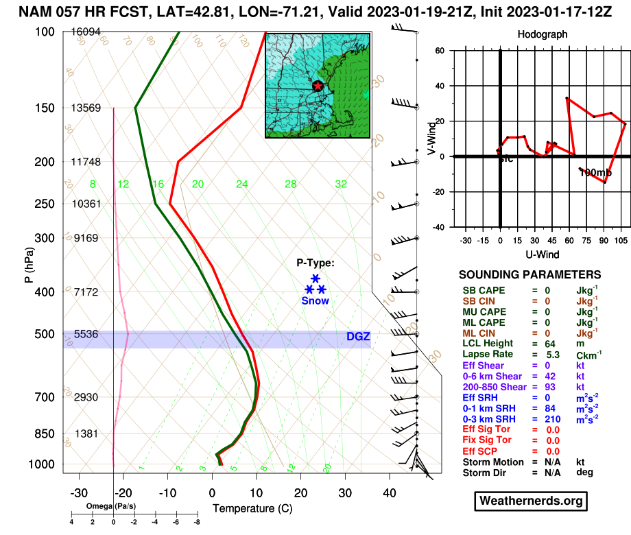
I think it goes over the FZDZ or snizzle right into Central NH for a bit once the mid-level dryslot punches through. The DGZ completely dries out, then resaturates by late-morning/midday Friday.
-
Nice thump on the nam with the first batch down to maybe route 2-ish, and especially closer to the NH border on north.
-
Nam looks a touch cooler for those on the fringes
-
EPS mean looks like it tracks over SE MA/Cape for Sun/Mon
-
What a bomb on the euro
-
What a weenie run for Stowe.
-
Pretty much over my head. It's a bomb though, big snows in NNE
-
A quick glance, but the euro looks a touch colder than 6z. Seems to have a little better lift, which might be helping.
-
Ukie looks like a big hit for the berks into CNE at 144hr
-
Riding the line that run. So borderline from the sfc up past 850. Gonna want a saturated DGZ with lift given that look. I'm in the "proceed with caution" crowd for us south of MHT. I'm not totally selling the first round, but there's not a ton of wiggle room.
-
12z NAM will definitely be a bump north with the mid levels, esp @850. Still fairly cool at the sfc
-
6z euro/nam looked pretty good down into northernmost mass. Gfs is a little warmer/north
-
It's almost useless at this range but the nam is pretty cold at 84hr.
-
Warm nose is centered around 850 on the soudnings and gets pretty warm, esp pike south on the 12z stuff. So, I think latitude will be in play too, and of course things could always shift always back north some. The 850 0 line, along with sfc Ts are probably a good approx R/S line for this one.
-
Picking back up in the Rockingham band. Great flakes
-
Yeah the last few gfs runs have been hitting that inverted trough type setup that blossoms as the upper level support approaches. Prolongs precip into Friday
-
That forecast gets some hourly high res influence in the short term (IBM Graf), so it can sometimes align with radar trends.
-
There was a wicked wedge up there around 925. Probably quite a bit of sleet contamination overnight into this morning. Temps also get kinda borderline today to max accretion across Downeast ME.
-
Id sell an inch, but there could be some more snow/sleet showers as the stuff off PWM tries to rotate southwest. Mesos show it to varying degrees, but it should be weakening.
-
Airmass is crappy in front of it, but yeah verbatim the euro has the freezing line extending into N MA for a good chunk of precip. I'm not expecting a whole lot, but worth watching the runs today for SNH, esp elevated areas.
-
2.5". Still snowing pretty good.
-
Picked up over 1" in the last hour when that band rotated through. Back down to light snow. 1.7" so far
-
Pounding in this band rolling through Rockingham County