wx2fish
-
Posts
2,631 -
Joined
-
Last visited
Content Type
Profiles
Blogs
Forums
American Weather
Media Demo
Store
Gallery
Everything posted by wx2fish
-
Fake damage, fake cold, fake snow...atleast he's consistent
-
Them to South Nashua just oblitered
-
MHT -2.5 CON -2.8
-
Even MHT looks like a lock to finish JJA BN, and I'm still convinced it's running warm. Atleast give me some sun. I've had about 15 minutes in the past 3 days.
-
Really training along the NH seacoast right now.
-
The 2023 Lawn, Garden, Landscape Party Discussion
wx2fish replied to Damage In Tolland's topic in New England
Just had the entire lawn stripped, regraded, loamed and seeded. Seed went down on Monday and it's popping pretty good. A little early, but given the pattern decided to go for it. -
Today just evaporating on the nam and hrrr. Best rains might be in NNE with late day storms.
-
12z 3k nam is another 5-6" for NE MA
-
The 2023 Lawn, Garden, Landscape Party Discussion
wx2fish replied to Damage In Tolland's topic in New England
Some of the pines are so loaded here they have that droopy iced up look from a distance -
I almost bought tickets for last night, but didn't pull the trigger. Now glad I didn't. I can see both sides, but didn't he refund a show in the past for losing his voice? That would set a similar precident, granted this was a stadium show with alot more people.
-
July has arrived ... the Meteorologically defined mid summer month
wx2fish replied to Typhoon Tip's topic in New England
My last 3 July's are 11", 1.5", 9" so far this year. As wet as its been I'm still not up to 2021 yet. -
MHT probably got more .15" in the past 10 minutes
-
Remnant circulation went almost overhead. Had a quick G30+ as it moved through.
-
July has arrived ... the Meteorologically defined mid summer month
wx2fish replied to Typhoon Tip's topic in New England
Last summer was better. Way less cloud cover and rain around here. I'm not a big gardener so ill take stein over mildew. -
July has arrived ... the Meteorologically defined mid summer month
wx2fish replied to Typhoon Tip's topic in New England
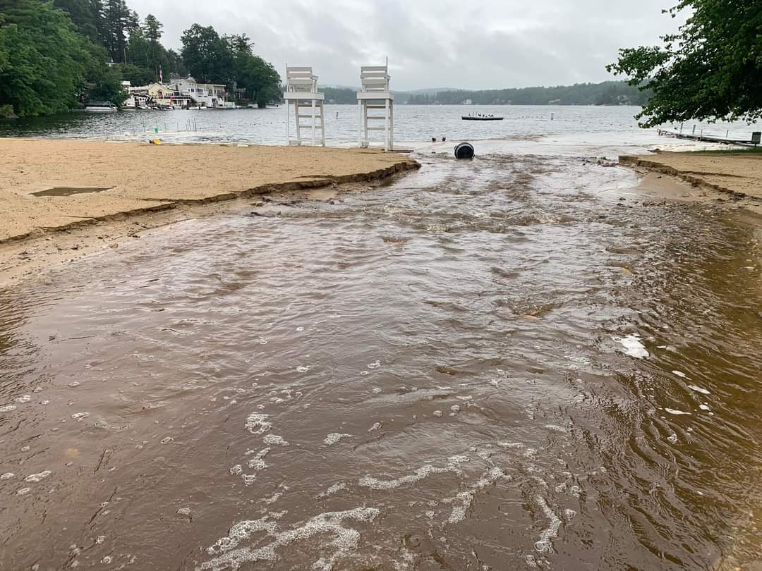
He got the town beach.

-
July has arrived ... the Meteorologically defined mid summer month
wx2fish replied to Typhoon Tip's topic in New England
3.35" in the stratus. Davis went a little wild at 3.60". Just what we needed after a 6" month. -
July has arrived ... the Meteorologically defined mid summer month
wx2fish replied to Typhoon Tip's topic in New England
Been pretty nuts. Lots of washouts and ponding. Even if the Davis went a little wild, radar estimates are over 3" now in the general area. -
July has arrived ... the Meteorologically defined mid summer month
wx2fish replied to Typhoon Tip's topic in New England
My davis may hit 3". I have a stratus to check when it's done. Sometimes the Davis seems to go a little wild in heavy rates. It's usually fairly close in lighter rains -
July has arrived ... the Meteorologically defined mid summer month
wx2fish replied to Typhoon Tip's topic in New England
What a deluge in this MA/NH border band. Davis hitting 3-4"/hr rates -
July has arrived ... the Meteorologically defined mid summer month
wx2fish replied to Typhoon Tip's topic in New England
Just meant MHT would go from -1.9 to -2.5 if you exclude the first 2 days of the month. But yeah, the biggest departures were definitely front loaded in either direction. -
July has arrived ... the Meteorologically defined mid summer month
wx2fish replied to Typhoon Tip's topic in New England
The first 2 days of the month were also 93-95. Helped pull up the negatives a little. -
It's pushing 1SM at the first lake now, probably less. About as smokey as I've seen it.
-
I'm right on the First CT Lake and it's been getting worse. Probably around 3SM now. Starting to get tough to see across the lake.
-
I'm up in Pittsburg. Heavy heavy smoke today
-
Thanks, I suspected it was running warm. Still putting up a -3 for June too.