JC-CT
-
Posts
18,191 -
Joined
-
Last visited
Content Type
Profiles
Blogs
Forums
American Weather
Media Demo
Store
Gallery
Everything posted by JC-CT
-
Earth's axial tilt as it orbits the sun is independent of your opinion of sensible weather outcomes in your backyard. Warm, snowless winters are still winters.
-
What a winter
-
Respect the gulf
-
I wouldn't say we have a great grasp on the amount that chaos factors into it.
-
POT COOKIES
-
I think they mean pot cookies
-
The GFS is about to crazy around the turn of the month, but there is support on the EPS and Euro for a decent ridge out west to form.
-
There actually seems to be a decent pattern setting up in the day 8-10 range. Not super long-range, enough to give the overall 500mb pattern some credence.
-
Don't look at the canadian
-
Maybe some well-timed HP on the GFS for the next one? Another thread the needle
-
I mean, maybe we can get this 200 miles NW and get some CAPE into the region
-
I guess if you really wanted to do that to yourself - There is another strong ULL out in the Pacific about halfway between HI and AK that ejects some energy into the CONUS after our main wave. We've had storms ruined at the last minute by a kicker shunting them east, it's always possible this follow-up wave comes in at a strength/orientation/timing that is more conductive to acting as a kicker. I wouldn't bet anything on it though.
-
Somebody get this man a cookie, stat.
-
Is that in Ukraine
-
Not me, I'm still working hard and busting my ass to make it snow.
-
Is it really dryslotting if the slp is over our head or even north of us? Plenty of qpf...
-
I did notice that the NAM wants none of this unphased competing vortmax stuff over the midwest/TN valley.
-
Right...yay for getting a faster shit
-
Pretty much, from BOX This Weekend... The latest longer range guidance continues to depict potential for a coastal storm sometime Saturday night into Sunday night, possibly evening into Monday morning. Considerable uncertainty remains on the exact track and timing of the various components of this system, which is not all that unusual this time of year. There is rather high confidence we will see a period of measurable precipitation. Confidence is much lower on the timing and precipitation type details. Took a consensus/ensemble mean approach to smooth over the less predictable details. That pattern suggest more of a rain/snow mix across southern New England, instead of a big snowstorm for everyone. Snow more favored across the interior, especially at night. Both options remain possibilities, however. There is some blocking expected to our north, so this could be a slow- moving coastal storm. It may be Monday morning before this low pressure moves offshore.
-
I take it back, it was right after
-
He stopped it right before the best storm
-
Yeah there's that
-
But it's not blue...
.thumb.png.300d5ca1e32d01d04b6eebc019c1a4f9.png)
-
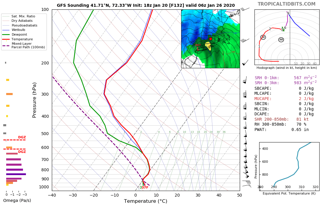
I'm selling him being at 36F at the surface while the entire column from 925 up is below freezing. Hard sell. Even borderline for me, verbatim.

-
Well there is energy in both streams that are in play, it looks like maybe the shortwave currently off the coast of Baja wants get out ahead?


.png.87718e37b0e36485d35b0969ba020af6.png)