metagraphica
-
Posts
2,176 -
Joined
-
Last visited
Content Type
Profiles
Blogs
Forums
American Weather
Media Demo
Store
Gallery
Everything posted by metagraphica
-
 EXPENSIVE week incoming.
-
January 25-26th, 2026 Final Storm Totals
metagraphica replied to The 4 Seasons's topic in New England
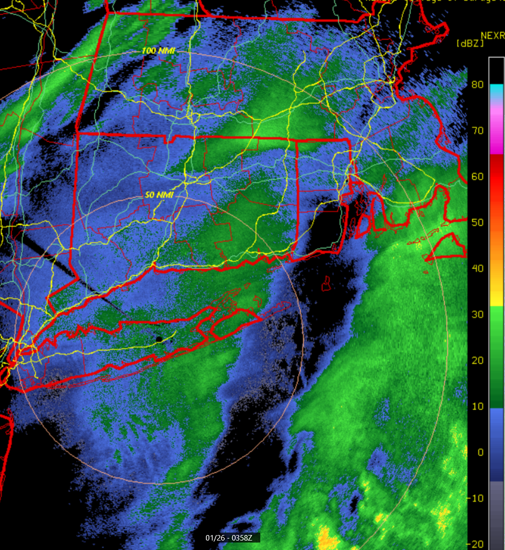
15.1" total. Although looking at radar we might get some light snow later this evening. 33.2" for the season so far. -
15.1 total for yesterday and whatever little bit we got overnight. Flurries for most of the morning. We'll see if we can pull of another inch or so later today. Radar looking good.
-
Nice band building in after the dryslot shot through. All snow again.

-
Very similar to what I have. 7" and 7.5" were my two measurements with a 14" depth at 8:30. Been full on sleet since 9pm.
-
Waffling between sleet, snow and sleet snow mix. Heavy sleet while I was out clearing the board and getting measurements 10 minutes ago. Back to a mix just now. 7.5" new 14.5" total. Current depth 14". Warmed up to 20 degrees now.
-
Other than a very brief period of tiny ice pellets mixed with snow around 4:30 we've been all snow up here. (just over the border from East Lyme in Salem)
-
4.5" new. 11.5" total @ 4pm. Went out and shoveled part of the driveway. I hate getting old.
-
30+ dbz now. Vis down to 1/8th or less. Hoping it doesn't start pinging soon.

-
https://i.imgur.com/9S7SLwx.mp4
-
Definitely think we'll see lot's of mid-20's for totals. Maaaaaybeee a 30 burger somewhere.
-
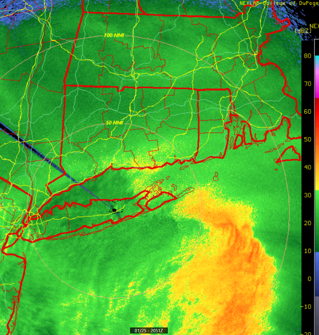
1st board clearing and measurement done at 2:30pm (6 hours since start of precip). 7" inches at that time. 11 degrees. Puking snow. 1/4 mile visibility or less.
-
Must be your mobile. Looks perfectly normal on my PC.
-
Snow started about 20 minutes ago. Everything white already.
-
F*ck!!!!
-
“Cory’s in LA! Let’s MECS!” Jan. 24-26 Disco
metagraphica replied to TheSnowman's topic in New England
That'll be right on my doorstep. We'll see what it does. Still looking forward to a big 12" here. -
“Cory’s in LA! Let’s MECS!” Jan. 24-26 Disco
metagraphica replied to TheSnowman's topic in New England
1.3" at ~12/1 ratio. I'll take it. -
“Cory’s in LA! Let’s MECS!” Jan. 24-26 Disco
metagraphica replied to TheSnowman's topic in New England

-
“Cory’s in LA! Let’s MECS!” Jan. 24-26 Disco
metagraphica replied to TheSnowman's topic in New England
It's gonna snow.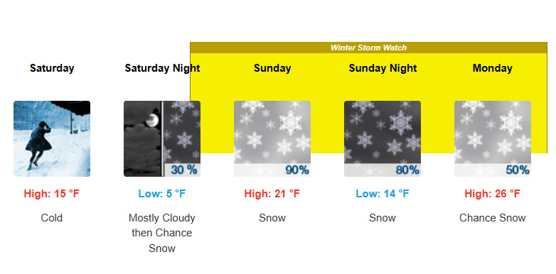
-
January 2026 regional war/obs/disco thread
metagraphica replied to Baroclinic Zone's topic in New England
At least today is 44. Not looking forward to 40 days and 40 nights of BN and snow. Feels like 2015 walking in the door. -
“Cory’s in LA! Let’s MECS!” Jan. 24-26 Disco
metagraphica replied to TheSnowman's topic in New England
"And so it begins." -
January 2026 regional war/obs/disco thread
metagraphica replied to Baroclinic Zone's topic in New England
It's gonna snow. Currently 0 degrees IMBY. Fookin' cold.