

metagraphica
-
Posts
1,667 -
Joined
-
Last visited
Content Type
Profiles
Blogs
Forums
American Weather
Media Demo
Store
Gallery
Everything posted by metagraphica
-
Fantastic! Warm and dry Spring day. 61/22.
-
0.0" depth. Down 4" from peak depth.
-
As interesting as it would be to see PF's Mount Mansfield stake make a run at a record depth, this polar vortex needs to GTFO! I'm ready for an early spring.
-
Meanwhile down on the shore KGON jumped from 37 to 50 in 18 minutes.

-
Interesting obs right now. 55 at Montauk. Still only 37 at GON. Can't imagine that happens too often.
-
When is that 40+ degree air coming in? Still rotting at 33/32 with heavy rain showers blasting through. At least the power is back on. Left the generator hooked up for when it goes out overnight with the high winds.
-
Pretty sure Neversource is caught with their pants down. Haven’t seen hardly any of the early morning outages get cleared from the outage map so far. Just keep seeing more and more get added. 4+ hours so far. 33/32 with drizzle. .
-
Hit 32 a little after midnight but then back down to 30 and now sitting at 31 with pouring rain. Looks to be about a quarter inch of ice on everything. And, of course, my power went out right around 6:35am. FML. .
-
32 and rain here. Changed over in the last hour. KGON up to 34. Manage to get 1.5" of snow, graupel and pellets before change over. Snow was a weird texture most of the evening. Clumps of needles mixed with white pellets, so despite strong radar returns it never amounted to much depth.
-
That's what I'm afraid of. With the frozen ground the rain is going to have no where to go except to pool in my yard, basement, etc...
-
38/36 currently. Melt in progress.
-

South shore Obs/Nowcast for Feb 11-12 light snow
metagraphica replied to Sey-Mour Snow's topic in New England
1.4" in Salem. FYI... -
South shore Obs/Nowcast for Feb 11-12 light snow
metagraphica replied to Sey-Mour Snow's topic in New England
Nice 1.4" refresher. -
I see mid/upper 40's. Can I get a 50?
-
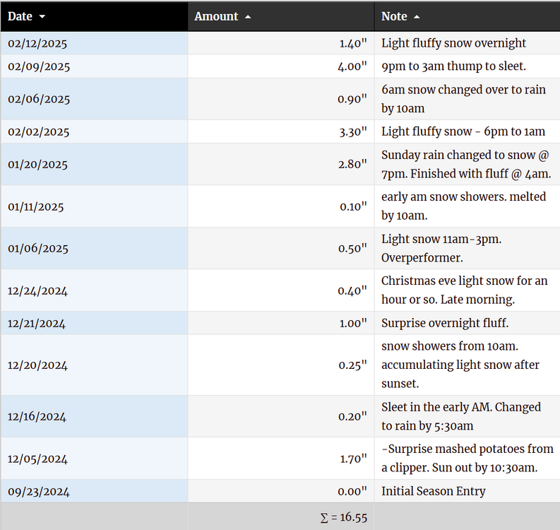
16.55" total so far. Slightly behind last year. Ahead of 22-23.
-
This reflectivity depiction looks remarkably similar to what we just had this past Saturday/Sunday. (no idea if the 500mb is similar though)
-
4.0 Final here.
-
A few pingers mixing in with light to moderate snow. 3.8"
-
Currently 30/18 - gotta saturate that column. I'm thinking 6 or 7 inches IMBY.
-
Gotta love this place.
-
Tracking February 6. Light to moderate event potential
metagraphica replied to Typhoon Tip's topic in New England
I'd put it at 0.9" here in Salem. Never made it to an inch before changing over. Currently 36 with drizzle and fog. Just a nasty day all around. -
Tracking February 6. Light to moderate event potential
metagraphica replied to Typhoon Tip's topic in New England
Had just under an inch, but sleet/frzdz now. Temp jumped up to 32 in the past 30 minutes. -
Tracking February 6. Light to moderate event potential
metagraphica replied to Typhoon Tip's topic in New England
WWA posted URGENT - WINTER WEATHER MESSAGE National Weather Service New York NY 309 PM EST Tue Feb 4 2025 CTZ005>008-NJZ002-004-103-105-107-NYZ067>070-051100- /O.NEW.KOKX.WW.Y.0004.250206T0900Z-250206T1800Z/ Northern Fairfield-Northern New Haven-Northern Middlesex-Northern New London-Western Passaic-Eastern Passaic-Western Bergen-Western Essex-Western Union-Orange-Putnam-Rockland-Northern Westchester- 309 PM EST Tue Feb 4 2025 ...WINTER WEATHER ADVISORY IN EFFECT FROM 4 AM TO 1 PM EST THURSDAY... * WHAT...Mixed precipitation expected. Total snow and sleet accumulations up to two inches and ice accumulations up to one tenth of an inch. * WHERE...Portions of southern Connecticut, northeast New Jersey, and southeast New York. * WHEN...From 4 AM to 1 PM EST Thursday. -
Yeah, past 45 minutes have been roaring. Stuff banging around outside. Nice gust to 44 at KGON. edit: BDL and HFD with big gusts too.
-
Sunday Evening/Night Light snow event Disco/Obs
metagraphica replied to Sey-Mour Snow's topic in New England
3.3" light and fluffy. Super easy to shovel this morning.


