

Windspeed
-
Posts
4,611 -
Joined
-
Last visited
Content Type
Profiles
Blogs
Forums
American Weather
Media Demo
Store
Gallery
Everything posted by Windspeed
-
 Well the micro-vortex is the tiny eye we observed with Hagibis. Really this phenomenon is no different than your average microcane or small hurricane eyewall in general, it just takes a very low shear environment + very high maximum potential intensity w/ high TCHP to get something like a Hagibis or Wilma; and even still, the aformentioned type of micro-vortex may still not occur. Otherwise, outer banding influences in the formative stages usually starves off or dissipates a smaller vortex before MPI can be achieved. Usually the intensification phase of the entire tropical cyclone's broader core cuts off or diverts outer low level convergence rather quickly away from a tiny interior vortex, if it happens to exist, while a larger eye or concentric band takes over. This is usually prior to the system even becoming a hurricane or typhoon. It's just a really chaotic and unpredictable process, at least until the main eyeband or core has consolidated, to know how large or small the dominate vort will be. In short, there really isn't a way to model the chaotic nature of such a phenomenon. It is rather part luck on how small and aligned an MCS-induced mid-level vort is in conjunction to the low level vort underneath. If that can resolve and the MPI is sky high, a small vort can become dominant and remain that way through rapid intensification all the way into the sub-900s hPa. But it's really a crapshoot to know the probability of such occurring. Sometimes the original vort max is just larger and remains that way.
 -
Radar confirms that Super Typhoon Hagibis did not actually make landfall on Anatahan Island. The southern periphery of the island got scraped by the core, but the worst conditions of the inner boundary of the eyewall missed just offshore. Again, good example how satellite imagery can be deceiving as it looked like a direct hit in the posts above. Angle of sensor, parallax and lat/long postion of eye is important.
-
Rare is a better term. I mentioned some others above: Pam, Patricia, Wilma, Gilbert and Allen all had similar structures. There have been a number of others that developed a super intense >5nm micro-vortex eyewall within a much larger banded concentric envelope. Still, it's not something we see with regards to such extreme sub 890 hpa estimated intensities on a yearly basis. Think perhaps once every 5-10 years globally within the satellite era.
-
Yes, it was inhabited prior to volcanic unrest. The caldera has been active in recent times with a VEI-4 eruption in 2003. Anatahan is a desolate place that nobody has returned to. I should also say that based on angle of satellite and parallax, it may look like a landfall, but we'll need to confirm it with the radar beam out of the N. Marianas. The base of the tiny 3nm wide vortex may actually be missing south of Anatahan though it looks like a direct hit on the island. Edit: Sorry for edits, Tapatalk is being annoying and lagging posts atm.
-
Well-formed small vortex in the right place at the right time. Nearly all requirements for RI and MPI met at once. Strong banding around such a small vortex will eventually halt this round but there will likely be reintensification after ERC with a larger eye. Having said that, based on sat estimates, peak intensity has been achieved. At this time there isn't much off structurally in comparison to Patricia or Wilma. The eye is doing a trochoidal wobble that may slingshot it right over the island -- a possible sub 900 hPa hit of you've ever seen one.
-
If there is a silver lining, it's that due to the low soil moisture content and dry airmass in place, humidity has been low in the upper Tennessee Valley. So it's been a dry heat for us. The nights have been very comfortable. Now, of course, for the Piedmont, coastal plain/fall line and areas east and south I am sure it's been miserable. That's not much of a silver lining because obviously we're in a drought. Fortunately we're well past growing season for most crops. My lawn is basically dead and brown. Have not bothered mowing in three weeks. Not even weeds are having any of this...
- 179 replies
-
- 2
-

-
- record heat
- transition
- (and 4 more)
-
Ridiculous...
- 179 replies
-
- 3
-
-
- record heat
- transition
- (and 4 more)
-
- 179 replies
-
- 3
-
-
- record heat
- transition
- (and 4 more)
-
McLean's Town, one of the communities in eastern Grand Bahama. It's pretty much what you would expect.
-
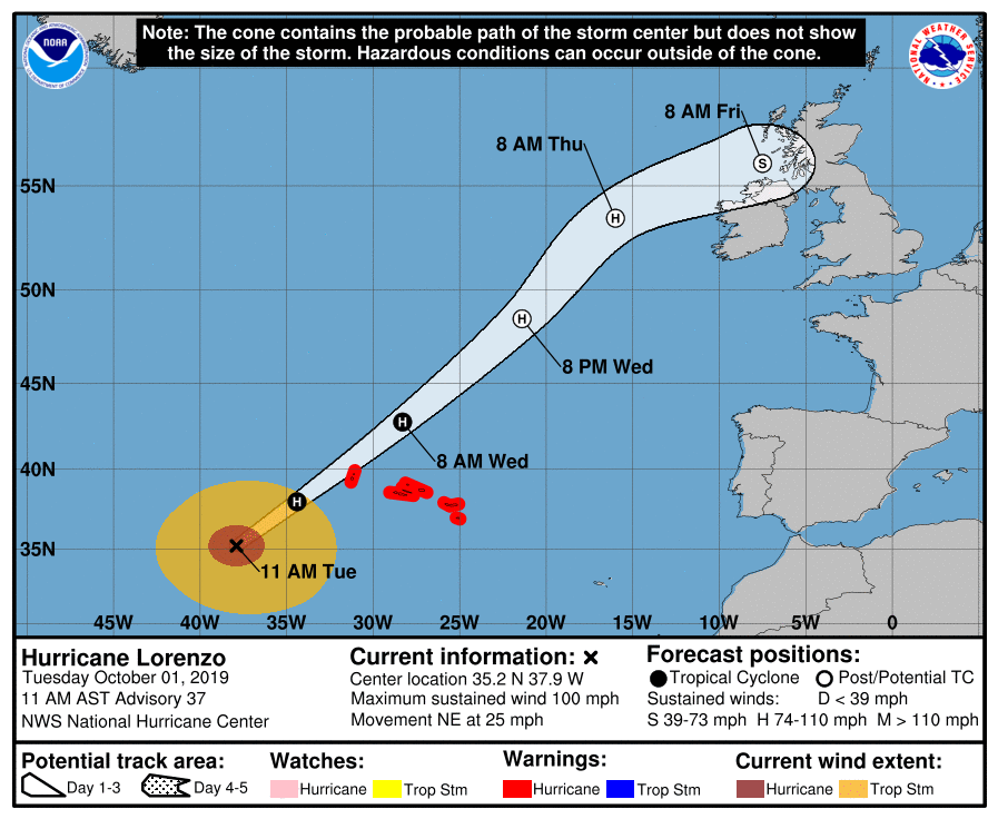
Lorenzo's eye crossed 2 degrees of longitude in less than 5 hours. It's moving at nearly 25 mph now and that forward motion continues to increase.
-
723 WTNT43 KNHC 011454 TCDAT3 Hurricane Lorenzo Discussion Number 37 NWS National Hurricane Center Miami FL AL132019 1100 AM AST Tue Oct 01 2019 Lorenzo remains a well organized hurricane this morning as it heads toward the Azores. The eye has made a reappearance in infrared satellite imagery, and the cloud tops associated with the surrounding ring of convection have cooled. The advisory intensity remains 85 kt, which is the consensus of the latest objective and subjective satellite intensity estimates that range from 77 to 90 kt. Lorenzo is expected to maintain its intensity today, but it will be moving over progressively colder waters and into an area of increasing shear, which should cause gradual weakening by Wednesday. The global models show the hurricane merging with a frontal zone, and becoming extratropical in about 36 hours. The extratropical low should weaken in a couple of days while it moves near Ireland and Great Britain, and then it is forecast to dissipate over Europe by 96 hours. Lorenzo is moving northeastward at 22 kt. The hurricane should continue to accelerate northeastward ahead of a mid-latitude trough over the central Atlantic during the next day or two. After that time, the cyclone is predicted to decelerate and turn east-northeastward or eastward within the low-level westerly flow. The global model guidance is in excellent agreement through the first 36-48 hours, and has also come into somewhat better agreement on the eastward turn later in the period. The updated NHC track has been adjusted southeastward at 72 hours, but still lies north of the multi-model consensus. An additional southward and eastward adjustment of the post-tropical cyclone's track near Ireland and the United Kingdom may be necessary in future advisories. Lorenzo is producing huge seas over the north Atlantic. Full information on the High Seas Forecasts can be found at the Ocean Prediction Center under AWIPS header NFDHSFAT1, WMO header FZNT01 KWBC, and online at ocean.weather.gov/shtml/NFDHSFAT1.php. The UK Met Office also has information in High Seas Forecasts issued by under WMO header FQNT21 EGRR and on the web at http://www.metoffice.gov.uk/public/weather/marine-high-seas/ Key Messages: 1. Lorenzo is expected to bring hurricane and tropical storm force winds to the Azores beginning tonight, and these conditions will continue into Wednesday. Hurricane and Tropical Storm Warnings are in effect for the Azores. 2. Swells generated by Lorenzo have spread across much of the North Atlantic, and are affecting the east coast of the United States, Atlantic Canada, the Bahamas, portions of the Greater and Lesser Antilles, and portions the coast of Europe. These swells will produce life-threatening surf and rip currents. FORECAST POSITIONS AND MAX WINDS INIT 01/1500Z 35.2N 37.9W 85 KT 100 MPH 12H 02/0000Z 38.0N 34.4W 85 KT 100 MPH 24H 02/1200Z 42.8N 28.3W 75 KT 85 MPH 36H 03/0000Z 48.5N 21.4W 70 KT 80 MPH...POST-TROP/EXTRATROP 48H 03/1200Z 53.5N 16.0W 65 KT 75 MPH...POST-TROP/EXTRATROP 72H 04/1200Z 56.0N 7.5W 45 KT 50 MPH...POST-TROP/EXTRATROP 96H 05/1200Z...DISSIPATED $$ Forecaster Brown
-
All known category 5 hurricanes whether by operational, post-analysis or historical reanalysis have made landfall at minimal hurricane intensity or stronger in the Atlantic basin. If Lorenzo makes landfall over Corvo or Flores islands in the Azores archipelago, that streak will continue. Best track has it just missing them for now. A slight deviation east is needed for any official landfall.
-
2019 Atlantic Hurricane Season
Windspeed replied to AfewUniversesBelowNormal's topic in Tropical Headquarters
MJO has moved into a suppressive phase. But we'll see where everything lines up in about 10 days. In the meantime it should be quiet. -
Upper tropospheric temperatures are cooling as Lorenzo gains latitude. There is also the deep layer trough moving in. I suspect both enhancements are countering the drop in SSTs, though Lorenzo is still over sufficient heat content to support a Cat 2. The structure has improved in so much it should at least maintain intensity for the next day until asymmetric transition begins.
-
-
Tennessee Valley 2019 Fall Speculation/Forecasting
Windspeed replied to AMZ8990's topic in Tennessee Valley
Thanks for ruining my day, Jeff. lol...- 574 replies
-
- 4
-

-
- early winter
- leaves changing
- (and 3 more)
-
2019 Atlantic Hurricane Season
Windspeed replied to AfewUniversesBelowNormal's topic in Tropical Headquarters
Such development is very typical of the pattern. The fantasy storm is developing out of a SW Caribbean-Central American surface trough/gyre, not entirely different from Nate in '17 or Michael in '18. Essentially westward propagating tropical waves move into contact and interact with said gyre, amplifying low-level convergence. All you need is a decent upper level high in place and voila. Also steering currents and place of cyclogenesis is critical, of course; and some monster storms have developed out of these features over the years: Mitch, Otto, Wilma, Kate, Michael being the most notable. Hopefully anything that does develop remains weak or doesn't go through one of the aforementioned major hurricane landfall scenarios. -
-
It's official....Category 5 Lorenzo. Astonishing. 000 WTNT63 KNHC 290207 TCUAT3 Hurricane Lorenzo Tropical Cyclone Update NWS National Hurricane Center Miami FL AL132019 1010 PM AST Sat Sep 28 2019 ...LORENZO STRENGTHENS INTO A CATEGORY 5 HURRICANE... Recent satellite data indicate that Lorenzo has continued to rapidly strengthen to an extremely dangerous category 5 hurricane with maximum sustained winds near 160 mph (260 km/h). This increase in intensity will be reflected in the forecast issued at 11 pm AST (0300 UTC). SUMMARY OF 1010 PM AST...0210 UTC...INFORMATION ---------------------------------------------- LOCATION...24.1N 45.0W ABOUT 1410 MI...2270 KM SW OF THE AZORES MAXIMUM SUSTAINED WINDS...160 MPH...260 KM/H PRESENT MOVEMENT...N OR 360 DEGREES AT 10 MPH...17 KM/H MINIMUM CENTRAL PRESSURE...925 MB...27.31 INCHES $$ Forecaster Brown/Latto
-
Ridiculous....
-
lol...
-
To say Lorenzo is impressive in the Satellite Era would be a one hell of an understatement.
-
Anybody else noticing this? Lorenzo is bombing again. Holy crap, Batman...
