

Windspeed
-
Posts
4,611 -
Joined
-
Last visited
Content Type
Profiles
Blogs
Forums
American Weather
Media Demo
Store
Gallery
Everything posted by Windspeed
-
Whooooo!!! Dog days are kicking in early boys! [emoji91][emoji91][emoji91]
-
Late July into the first week of August just might be the kickoff. Signs of a favorable MJO coming into play. Easterly winds will dominate the tropical Pacific region, reinforcing La Niña; at the same time, due to a robust standing wave over the Western Indian Ocean and East African highlands, convection should continue to propagate westward with persistent wave breaking, which will feed tropical waves into Eastern Atlantic and MDR:
-
JMA on board for an active Aug-Oct throughout the Atlantic Basin and MDR.
-
The proverbial calm before the storm?...
-

2020 East & Central Pacific Hurricane Season
Windspeed replied to jgf's topic in Tropical Headquarters
The lateness for our first EPAC hurricane is moving up the historical record. -
The naming of Winter storms has always been controversial due to unwarranted exemplification of ETs/mid-latitudinal storms, their frequency of occurrence, and hype that overwhelmingly isn't required from a human impact and safety standpoint. The naming of Tropical Cyclones, on the other hand, is entirely warranted due to those same phenomenon. We name them because they can be inherently dangerous. Sure, some are just a maritime nuisance. Also, sure, with better RS technology, better satellite resolutions and data gathering, we classify TCs that likely wouldn't even get noticed several decades ago. But sticking to the rules of what gets classified, it would be silly to keep them unclassified merely because they are weak, less substantial/impactful events, or even subtropical. We name TCs for important reasons, hard to argue against that. But we also need to stick to the rules. If a system meets the criteria, it gets classified, period. I realize the tongue-in-cheek on the off-topic here. But it's worth reminding and pointing out why NOAA/NHC handles TC classifications the way they do, and also why private companies naming mid-latitudal ETs is ridiculous and of little credence beyond attention generation and money for their service platforms. It's hardly a matter of public safety and science. Major differences in mission strategy and purpose here.
-
Another healthy wave south of the Verdes. Easterlies are still a bit lopsided towards the 700 hPa level. But the wave train continues. Eventually easterly trades are going to better align as Azores ridging takes its seasonal build/shift westward into an ECONUS WAR/SER; we already have ENS support for strong interior CONUS 600 dm heights incoming; and if these waves continue training, ITCZ wave breaking and an axii is inevitably going to close off at the surface and stack. The vigor in the WAM and ITCZ needs to be paid attention. We are mere weeks away from modeled increasing MDR favoribility. If that happens sooner, expect one of these waves to develop into our first MDR TC before August.
-
Special Message from NHC Issued 9 Jul 2020 20:17 UTC NHC will initiate advisories on Tropical Storm Fay, located just east of North Carolina, at 5 pm EDT. 000 WTNT31 KNHC 092055 TCPAT1 BULLETIN Tropical Storm Fay Advisory Number 1 NWS National Hurricane Center Miami FL AL062020 500 PM EDT Thu Jul 09 2020 ...RECONNAISSANCE AIRCRAFT FINDS TROPICAL STORM FAY HAS FORMED JUST OFF THE COAST OF NORTH CAROLINA... ...EXPECTED TO BRING HEAVY RAINFALL AND GUSTY WINDS TO PORTIONS OF THE MID-ATLANTIC COAST AND SOUTHERN NEW ENGLAND... SUMMARY OF 500 PM EDT...2100 UTC...INFORMATION ---------------------------------------------- LOCATION...35.5N 74.9W ABOUT 40 MI...65 KM ENE OF CAPE HATTERAS NORTH CAROLINA ABOUT 195 MI...310 KM S OF OCEAN CITY MARYLAND MAXIMUM SUSTAINED WINDS...45 MPH...75 KM/H PRESENT MOVEMENT...N OR 360 DEGREES AT 7 MPH...11 KM/H MINIMUM CENTRAL PRESSURE...1005 MB...29.68 INCHES WATCHES AND WARNINGS -------------------- CHANGES WITH THIS ADVISORY: A Tropical Storm Warning has been issued from Cape May New Jersey northward to Watch Hill, Rhode Island, including Long Island and Long Island Sound. SUMMARY OF WATCHES AND WARNINGS IN EFFECT: A Tropical Storm Warning is in effect for... * Cape May New Jersey to Watch Hill Rhode Island including Long Island and Long Island Sound A Tropical Storm Warning means that tropical storm conditions are expected somewhere within the warning area within 36 hours. For storm information specific to your area, including possible inland watches and warnings, please monitor products issued by your local National Weather Service forecast office. DISCUSSION AND OUTLOOK ---------------------- At 500 PM EDT (2100 UTC), the center of Tropical Storm Fay was located near latitude 35.5 North, longitude 74.9 West. Fay is moving toward the north near 7 mph (11 km/h). A northward to north- northeastward motion at a faster forward speed is expected over the next couple of days. On the forecast track, the center of Fay is forecast to move near the mid-Atlantic coast on Friday, and move inland over the northeast United States on Saturday. Data from an Air Force Reserve reconnaissance aircraft indicate that maximum sustained winds are near 45 mph (75 km/h) with higher gusts. Some slight strengthening is forecast tonight and Friday. Weakening should begin after the center moves inland on Saturday. Tropical-storm-force winds extend outward up to 140 miles (220 km) primarily to the east and southeast of the center. The latest minimum central pressure reported by reconnaissance aircraft is 1005 mb (29.68 inches). HAZARDS AFFECTING LAND ---------------------- Key messages for Fay can be found in the Tropical Cyclone Discussion under AWIPS header MIATCDAT1 and WMO header WTNT41 KNHC. RAINFALL: Fay is expected to produce 3 to 5 inches of rain along and near the track of Fay across the mid-Atlantic states into southeast New York and southern New England. These rains may result in flash flooding where the heaviest amounts occur. WIND: Tropical storm conditions are expected to first reach the coast within the warning area on Friday and spread northward through the warning area Friday night. NEXT ADVISORY ------------- Next intermediate advisory at 800 PM EDT. Next complete advisory at 1100 PM EDT. $$ Forecaster Brown
-
Good thread on current anomalous upper tropospheric temperature profiles that may persist into the heart of the Atlantic hurricane season. Generally, cooler upper profiles aid in colder cloudtops and more intense convection. May also aid in upper divergence for 400-200 hPa anti-cyclones.
-
[emoji91][emoji91][emoji91]
-
The wave I posted above when it rolled off Africa is still making its way across the western MDR at a low latitude. It's nothing special, there may be some weak mid-level vorticity. It also isn't the sharpest of wave axii. But it has a favorable upper environment and if convection can coalesce to tighten vorticity or close off a surface low, could be interesting in the southern Antilles and deep Caribbean later this week.
-
The MCV accociated with the old boundary draped off the ECONUS might be forming an LLC under the current MCS complex that went up this evening. Note the circular pattern of the lightning near the highest cloud tops. Possible curved banding forming might be the beginnings of an LLC and we may get a named system out of this sooner than later if it holds together.
-
Fairly healthy wave axis with an MCS mid-level vort max south of the Verdes. Who knows if it will persist long with the SAL locked in to its NW. But interesting nonetheless. 12Z ECMWF does have a solution or two that closes off a surface low but there's negligible model support beyond that.
-
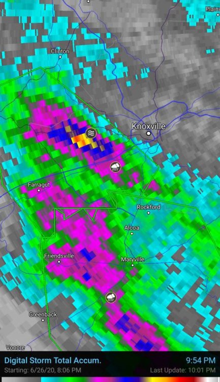
TN valley heavy rain/flooding week of whenever
Windspeed replied to janetjanet998's topic in Tennessee Valley
-
Classic La Niña taking shape. Questions remain on strength and coverage, especially in 3.4, but it is no doubt kicking in at this point. I suspect even a moderate La Niña would be a safe call, but still can't rule out a --ENSO either.
-
That particular model animation shows Azore's ridging below the 700 hPa layer of the atmosphere backing down over the eastern subtropical Atlantic. Surface-to-mid level pressures weaken slightly, retreating poleward. This eases low-level easterlies off Africa, which, in turn, limits SAL propagation westward off Africa. Additionally the ITCZ would become less suppressed south and gain some latitude within that pressure regime. This would help increase instability along the MDR, with better low-level convergence for convection, especially if the MJO is in a favorable phase aloft. Tropical wave tracks would also gain some latitude with the decrease in pressure heights, and be able to tap into moisture feed from the ITCZ. We generally see this pattern of strong Azores ridging back down in August, not early July. Typically a beefy late Spring to middle Summer eastern Atlantic Azores ridge is why we generally see SAL and too amped a low-level easterly jet to favor any MDR development. That, and upper level shear and vorticity is not yet favorable. At any rate, the pattern in the animation above may coincide with a favorable MJO [see below] and a relaxation of upper level wind shear across the Caribbean and lower MDR as well.
-
-
If SAL plumes continue to be lifted and break away into the easterly jet during the potential favorable MJO phase over the Atlantic, I am sure it would still have a negative effect on environmental conditions for cyclogenesis. But we have seen cyclogenesis occur with waves that were interacting with SAL in the past. It really just depends on location of a hypothetical wave axis versus the most hostile dry airmass and propagation of moisture flux out of the ITCZ. That's a remains to be seen kind of thing. Who knows...
-
Plumes of SAL dry airmass and aerosols riding the easterly jet should suppress activity for a few weeks at least. It will moderate with time as the ITCZ and individual waves begin to gain some latitude July-August.
-
Looks like AOML's OHC and TCHP maps are ingesting RS data correctly now. Still a vast spread of TCHP for mid-June, but way more realistic.
-
-
Loving it!
- 186 replies
-
- 1
-

-
- tennessee river valley
- wind
- (and 4 more)
-


