

Windspeed
-
Posts
4,611 -
Joined
-
Last visited
Content Type
Profiles
Blogs
Forums
American Weather
Media Demo
Store
Gallery
Everything posted by Windspeed
-

2020 East & Central Pacific Hurricane Season
Windspeed replied to jgf's topic in Tropical Headquarters
Hurricane Douglas cranking away in the EPAC. Looks like is on its way to becoming a major. May threaten Hawaii as a TS down the road. -
-
Invest91L has been designated. This has a decent chance of TCG in the central-to-NW GOM as conditions become more favorable. At this time there is still mid-to-upper level shear imparting over the western portion of the wave axis. But that should shift more easterly into the forecast period and allow some time for a potential low to stack. Not certain of any significant intensification but regardless, moisture fetch into very warm GOM SSTs could bring flash flooding rains into LA/Texas.
-
-
We may still have some bouts with a PV streamer, possible TUTT and some shear dependant on timing and positioning during the onset of an uptick in activity, aside from whatever 99L does here in the coming week.
-
Well 10-14 days is when I thought things would kick up. The current surprise MDR system is just an example of how you can still get activity in a mediocre and typically unfavorable environment. Yes, the timing convectively-coupled Kelvin moving out of the EPAC into GOM/WCARIB next week could be critical to 99L (potential Gonzo), etc.; however, the middle-to-upper MDR is still quite hostile. 99L just got lucky with its very low latitude with TCG here. We'll see how it all plays out.
-
New ASCAT. Vortex signature looks even better than last night. At this point, I'd be surprised TAFB didn't pull the trigger in the next hour.
-
Looks like a depression to me. Especially with that ASCAT pass last night confirming the closed low. All it needed was sustained convection and a bit more organization. Interesting how even a quiet stretch with most meh environmental conditions can still produce surprises. But 99L is an especially strong wave born out of a favorable environmental bubble thanks to the WAM and ITCZ boundary. Looks like if things continue, we'll get a NS. Questions remain if it can become anything substantial in the long term / Caribbean. It still has to deal with a lot of unfavorable possibilities.
-
Well then...
-
Considering that ASCAT pass, if we get any sustainable convection over that center, we'll probably get a classification. Clearly there is a closed low. Perhaps it doesn't survive the potential hostile environment in a few days, but it may still get named. Interestingly, this feature might spell trouble with the Western Caribbean next week. The favorable coupled Kelvin may be timing just right off to extend east off of Central America by then.
-
-
New paper by NOAA/OAR/AOML on the relationship between the Madden-Julian oscillation (MJO) and rapid intensification of tropical cyclones. Important Conclusions: 1. Rapid intensification events and the MJO tend to move with each other from west to east across the hemisphere suggesting a relationship between the two. 2. Rapid intensification is most likely to occur when the MJO is neither stormy and wet nor sunny and dry near the tropical cyclone. 3. The addition of information about the MJO does not improve forecasts of rapid intensification. This is likely because the information about the MJO is already available in the forecast models in a different form. Klotzbach (2012), in their seminal study on the relationship between RI in the Atlantic and the MJO, found that RI is four times more likely during the active MJO phase than during the inactive phase. The current study extends this work to the Central and East Pacific and tests whether the MJO may have predictive capability in current forecast schemes. All RI events in the north/western hemisphere along with the two commensurate RMM modes (Wheeler and Hendon 2014) are compiled from 1974 to 2015. The events are compiled into 20-degree-wide bins, and the mean values in each bin show that RI events and MJO events tend to move in tandem with each other from west to east across the hemisphere. Unlike in the Klotzbach (2012) study, the MJO is not generally in the most active convective phase in the region when RI occurs. Though the mean magnitudes are small, the differences between many bins are statistically significant. However, the addition of this information to statistical RI forecasting schemes does not significantly improve forecasts from SHIPS-RII, possibly because the MJO is not related to RI itself, but instead to cyclogenesis, a necessary precursor to RI, or due to the large scatter in the RMM values. Though the results here show a relationship between the MJO and RI events in the hemisphere, they do not show improvements to current operational RI-prediction models. Despite this, other techniques, such as those based upon machine learning or other artificial intelligence algorithms, might be useful to pursue in the future. Paper can be obtained here. Some additional thoughts of my own. Though clearly a favorable MJO or strong coupled Kelvin can help induce tropical cyclone genesis via an existing MCS, disturbace, wave, etc., there is clearly other factors at play with respect to an existing strong convectively coupled Kelvin and an already established TC going through RI. It may even be possible that a strong coupled Kelvin could create too much surrounding convection and competing micro regions of convergence that might limit low-level feed or interfere with the main vortex of an established TC. Also, since this paper focused on how currently existing RI models do not seem to benefit from additional MJO- Kelvin data, though an unfavorable MJO phase might deter RI, a favorable coupled-Kelvin doesn't necessarily increase existing parameters for RI of a potential TC. Essentially, though a convectively-coupled 200 hPa vorticity wave does greatly establish much better support of TCGs, it does not necessarily help in their RI phase if already mature, and that a neutral phase of the MJO might be the most conducive for RI of an existing TCG.
- 46 replies
-
- 1
-

-
- historical tropical cyclones
- hurricanes
- (and 3 more)
-
AL90 in the NW GOM looks too sheared over the potential weak circulation due to strong southeasterly flow. It's not got a lot of time remaining over water.
-
-
Hrmm...
-
2020 East & Central Pacific Hurricane Season
Windspeed replied to jgf's topic in Tropical Headquarters
As this intense convectively coupled Kelvin wave traverses over the EPAC, one would imagine some kind of TCG occurring there in the coming week. We shall see... -
RE: A potential switch is currently crossing the central into EPAC. A very intense convectively coupled Kelvin wave. This will be making its way over the Atlantic Basin in the 10-14~ day range. Surprisingly there are no signs of blossoming activity in mid-to-long range modeling yet, but that could easily change. Something to keep an eye on..
-
Meh...
-
It came off the lower 48 on a SSE track off the coast. Yes, you're correct, the feature is not moving SSE now. More S to SSW on a long bend into the southern periphery of building heights to the NW. It also needs to pulse up new convection relatively soon or the possibility of generating a LLC vort max will fade. The MCV may very well dissipate. At any rate, it was worth the mention. We've seen these little systems develop often enough after rolling off the lower 48 and SE.
-
An MCS moved SSE off of the ETX/LA coast into the NW GOM. It does have a weak MLC. This feature will turn SW, WSW and then W into the Central or Southern Texas coastline in about 36-48 hrs. So not a lot of time to develop; that being said, if convection persists and a low level vort can develop, there is potential for a TC to form prior to landfall. The upper pattern is favorable enough. At least something to keep an eye on...
-
-
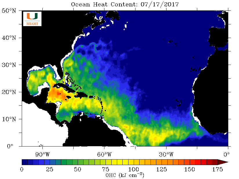
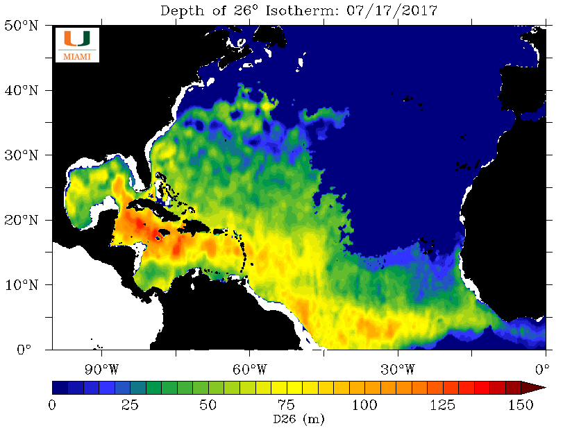
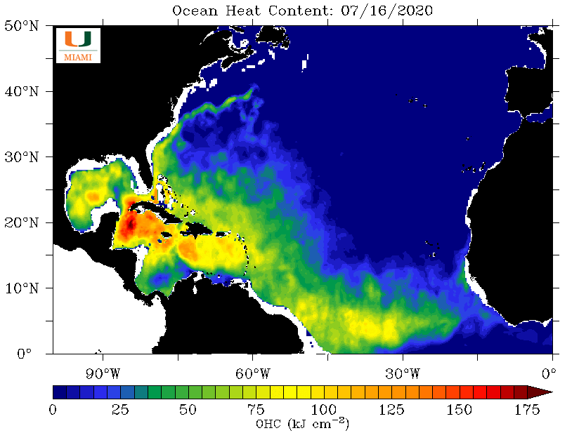
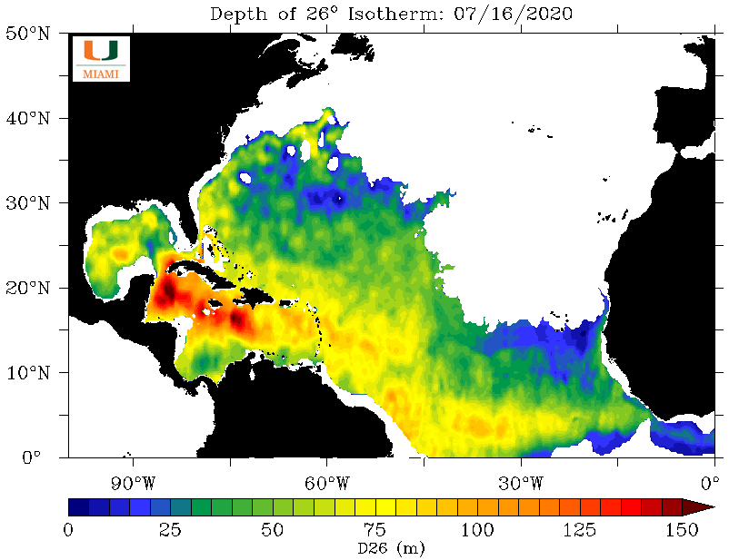
Current Atlantic oceanic heat potential compared to 2017, the last hyperactive season on record. Obviously heat potential and depth of 26ºC isotherm is only part of the equation. You need an anomalously favorable atmosphere and steering pattern. That being said, if the atmosphere over the Atlantic Basin does become more favorable in the coming weeks, the basin does look primed. July, 17th, 2017: Current: Now the question remains what atmospheric patterns will be in place for the last half of the Atlantic Hurricane season? 2017 had a relatively neutral ENSO but a positive AMO. NAO trended positive and IOD trended negative by September when all hell broke lose. Interestingly, a similar scenario may be unfolding by then but with an actual negative ENSO in place. We do not have a full blown negative ENSO yet, but it is trending that way.
-
-
Vertical profiles for most of the Caribbean and MDR are on point right now for TC support, however, SAL in the mid-to-lower levels and sinking air is keeping things quiet in the short-term. This is an ominous sign for when more favorable 200 mb support and 900 to 500 hPa lift begins to creep in by August however. I do expect things to go active and ramp up in a hurry when they do.

