Windspeed
-
Posts
4,611 -
Joined
-
Last visited
Content Type
Profiles
Blogs
Forums
American Weather
Media Demo
Store
Gallery
Everything posted by Windspeed
-
Uhm... This may get classified in short order. May not do anything crazy on a forecasted NW track into marginal waters and a more stable airmass. Still pretty suggestive ASCAT:
-
The vortex was devoid of convection for long enough time that 30kt winds likely were not mixing down below 960 hPa. So it wasn't really premature on their part. However, as these things sometimes can do, convection has reformed near maximum vorticity. Could they reclassify it? The system is still sheared, though it looks like the southerly mid-to-upper flow may have backed down some. It's about to pass the dateline and out of the NHC/CPHC/TAFB responsibility. JTWC may pick it up if the trend continues. It would also be renamed if it reintensified into a TS. This should turn NW and then N around an retreating ridge and head off into the northern Pacific, regardless.
-
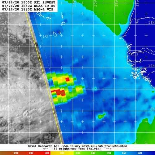
The current AEW southeast of Cabo Verde has a vigorous and compact mid-level vortex. Though 92L was a larger and perhaps more impressive wave, it struggled maintaining any MCS with its mid level vort and failed to genesis before reaching a more hostile environment in the MDR. This wave on the other hand may do better entering the MDR if it can concentrate convection and close itself off at the surface. It certainly looks decent at the moment.
-
Interestingly the new AEW near the CVs has decent model support for short-term TCG.
-
Douglas got guillotined...
-
I am not confident of eyewall interaction with the islands now. Yes the mid-level vortex is slightly tilted north of the low-level vortex, but the convection within the eye band looks like it may miss Oahu entirely if just clip Laie. It's possible that the mid-to-upper southerly flow is nudging the core more WNW besides causing shear. Edit: I should clarify the main islands. If the core were to somehow survive, it should cross the smaller Hawaiian Leeward Islands and atolls. I don't think it will manage that feat as a hurricane, surely not!
-
Truly remarkable...
-
Earlier in the thread, I doubted this would maintain hurricane intensity all the way into landfall, even with just gradual weakening. Douglas has surprised me to still have 80 kt sustained surface winds at its current location. That being said, it does look like the mid-level vortex is starting to tilt with increasing SSW directional flow above 500 hPa. I don't know, it's going to be a close shave to see if the islands get hurricane force gusts at sea level. Surely along volcanic peaks and ridges, but I feel like the biggest threat here could come from intense westerly orographic ascent producing flash flooding and debris flows. Not downplaying strong minimal cane/TS force gusts by any means if that is how it plays out. Definitely in rare event territory for Maui, Lanai, Molokai and Oahu. Hopefully enough significant weakening will lesson impacts by the time the llc reaches for Kauai.
-
-
-
In case anyone is curious, the next named "I" storm, Isaías, is pronounced "ee-sigh-ee-us". It's the Spanish name for Isaiah submitted by Argentina to the WMO.
-
Our new Cape Verde disturbance has been designated Invest 92L.
-
This is banter'ish, but is it really? lol...
-
NHC isn't playing around with the large wave / disturbance near the Verdes. Developmental chances already up to 40%. We'll probably have a cherry tomorrow. ZCZC MIATWOAT ALL TTAA00 KNHC DDHHMM Tropical Weather Outlook NWS National Hurricane Center Miami FL 200 PM EDT Fri Jul 24 2020 For the North Atlantic...Caribbean Sea and the Gulf of Mexico: The National Hurricane Center is issuing advisories on Tropical Storm Gonzalo, located less than 500 miles east of the southern Windward Islands. The National Hurricane Center is also issuing advisories on Tropical Storm Hanna, located over the western Gulf of Mexico a little more more than 200 miles east of Corpus Christi, Texas. 1. A tropical wave located about 300 miles south-southeast of the Cabo Verde Islands continues to produced an area of cloudiness and disorganized showers and thunderstorms. The disturbance is expected move westward across the tropical Atlantic during the next several days, and some gradual development of this system is possible by early next week when it reaches the western tropical Atlantic. * Formation chance through 48 hours...low...near 0 percent. * Formation chance through 5 days...medium...40 percent. Forecaster Stewart
.jpg.4df00c6dcf87e009fec31afe00cc7978.jpg)
-
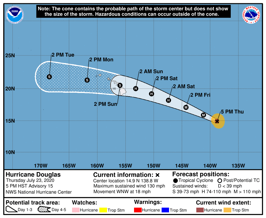
About to find out what a powerful hurricane can do with marginal ~25°C SSTs but good divergence aloft. I am going to say nothing too surprising. Douglas should continue a weakening trend from here on out. The upper trop temps aren't really cold enough to maintain high enough lapse rates to support the eyewall of a hurricane, much less a major, over the cooler body of water east of the islands. Douglas will probably have enough heat flux transport to weaken slowly versus rapidly though. Still, doubt it reaches the islands as a Cat 1.
-
The next AEW exiting the coast already had a large wave breaking sharp axis, but now with deep convection associated with a strong MCS embedded within its inverted surface trough. This is the wave the EPS and ECMWF op runs have been consistently developing the past few days into a formidable TC. I'd say based on appearance, that's looking ever more likely. It will still have some dry air established to its north in pockets across the subtropical Atlantic, but the easterly SAL burst is way out ahead of it and may not be as much a factor. Also, the moisture envelope with this wave is quite large. If TCG occurs in the MDR this weekend into early next week, this would be Isaias. The "I" storms are frequently in the historical record as being Cape Verde or deep MDR systems east of the Antilles, but generally well into September. Here we may very well experience an "I" storm in July of 2020, yet it will not break the mold. As the Euro would have it, our next TC might end up being a powerful long-tracking Cape Verde hurricane. Obviously, not to count chickens before they hatch as even if a very advanced AEW, it's still just a low-embedded wave that could flop and not get named. Nah, who am I kidding? This thing is a beast...
-
Looks like they've brought down intensity a tick upon island interaction. I think this is more realistic way to go with the intensity forecast. It could very well hold onto enough organization to be a strong TS but I have a hard time with keeping it a hurricane after traversing such cool water and a more stable air mass. 000 WTPZ43 KNHC 240243 TCDEP3 Hurricane Douglas Discussion Number 15 NWS National Hurricane Center Miami FL EP082020 500 PM HST Thu Jul 23 2020 Douglas remains a well organized hurricane in visible and infrared satellite imagery. The 15-nmi-wide eye remains very distinct and the surrounding cloud tops have cooled since the previous advisory. Although not evident in conventional satellite imagery, a recent AMSR-2 microwave satellite image showed evidence of concentric eyewalls. Subjective Dvorak T-numbers from TAFB and SAB are 6.0 (115 kt) and recent UW/CIMSS ADT estimates have been creeping upward, and now also close to T6.0. Based on these estimates, the initial wind speed has been raised to 115 kt, making Douglas a category 4 hurricane on the Saffir-Simpson Hurricane Wind Scale. Douglas has likely reached its peak intensity as it will be moving over cooler SSTs during the next day or so. Although the predicted track of the hurricane will bring it over warmer waters when Douglas approaches the Hawaiian Islands, vertical shear is forecast to increase at that time. This is expected to result in continued gradual weakening, however Douglas is forecast to be near hurricane strength when it moves close to Hawaii. Despite the slight increase in the initial intensity, the updated NHC wind speed forecast is unchanged from the previous advisory through 36 hours, and then follows the intensity consensus guidance thereafter. Douglas continues moving quickly west-northwestward or 295/16 kt. The hurricane is forecast to remain on this heading with some slight reduction in forward speed during the next day or so as it remains to the south of a large mid-level ridge. After that time, Douglas is forecast to turn westward to the south of another strong mid-level ridge the is predicted to build well north of the Hawaiian Islands later in the weekend. The new NHC track forecast is very similar to the previous advisory and lies just south of the various consensus aids out of respect of the ECMWF and its ensemble mean which lie along the southern edge of the track envelope. Key Messages: 1. Douglas is expected to move near or over portions of the Hawaiian Islands this weekend, and there is an increasing chance that strong winds, dangerous surf, and heavy rainfall could affect portions of the state beginning Saturday night or Sunday. Interests on the Hawaiian Islands should continue to monitor the progress of Douglas and the official forecasts as they evolve over the next few days. Watches could be issued on Friday. FORECAST POSITIONS AND MAX WINDS INIT 24/0300Z 14.9N 138.8W 115 KT 130 MPH 12H 24/1200Z 15.9N 141.2W 110 KT 125 MPH 24H 25/0000Z 17.1N 144.3W 100 KT 115 MPH 36H 25/1200Z 18.2N 147.4W 90 KT 105 MPH 48H 26/0000Z 19.2N 150.4W 75 KT 85 MPH 60H 26/1200Z 20.0N 153.2W 65 KT 75 MPH 72H 27/0000Z 20.5N 156.0W 60 KT 70 MPH 96H 28/0000Z 21.3N 161.8W 50 KT 60 MPH 120H 29/0000Z 21.8N 168.5W 45 KT 50 MPH $$ Forecaster Brown
-
Interesting thread on MJO phase 1 and 2 inter-seasonal as it relates to Atlantic Basin hurricane seasons. Note 2020...lol:
-
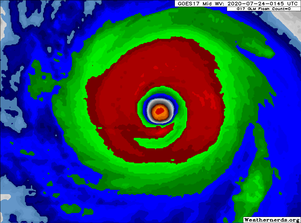
You can even pick up on the ERC underway from colorized WV. Note the developing moat. This would be much easier to see during the day with visible satellite. But it's easy enough to see on WV colorized IR.
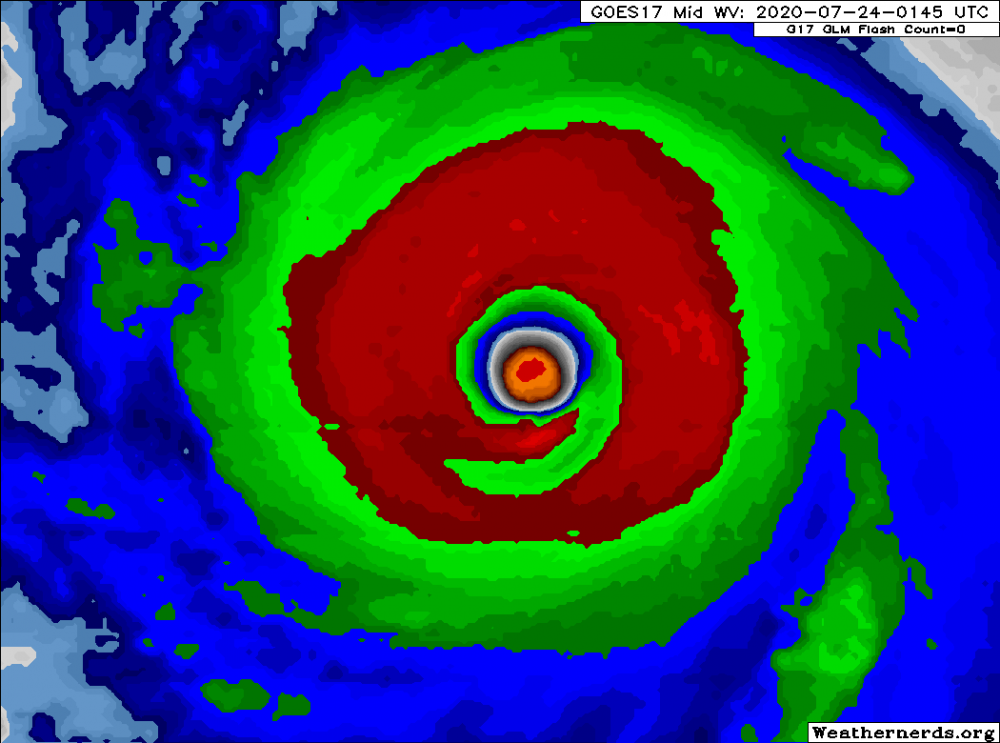
-
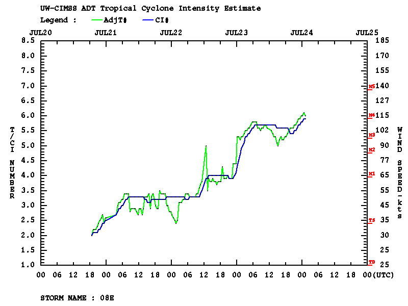
ADT supports the upgrade. It may not hold Cat 4 intensity long however as MW does show a concentric eyewall feature and an ERC is likely underway.
-
Looks like Douglas will be a Category 4 on the next advisory.
-
SSTs dip to 25°C east of the Big Island. If Douglas takes a more bending track back at the islands with a greater gain in latitude, I have doubts this will reach the islands as a hurricane. At least that is hurricane force at sea level. A strong TS is possible if the circulation winds down slowly. Interestingly, the top of Mauna Kea would be an interesting place to experience Douglas, as much higher winds in the 600 hPa level could produce hurricane force sustained. Mauna Kea is nearly 14k ft./4.2 km high around 614 mb mean.
-
Impressive..