

Windspeed
-
Posts
4,611 -
Joined
-
Last visited
Content Type
Profiles
Blogs
Forums
American Weather
Media Demo
Store
Gallery
Everything posted by Windspeed
-
¯\_(ツ)_/¯ I do know that with such a small and well defined surface vortex this has likely been a TC for ~12 hours, perhaps yesterday evening. But maybe it was too small to get picked up by the earlier ASCAT, though the most recent scans missed.
-
Gotcha! We should now have Nana.
-
So close...
-
Recon is finding westerlies. They appear to have missed south of the potential vortex and are still in the process of locating it. They'll need to make another pass but closer to Jamaica.
-
AF307 is almost in 99L. We'll know what we're dealing with soon enough. I still think winds on the north side will be strong enough to classify as a named storm if they find a closed vortex.
-
Jamaica is not yet near any potential vorticity maximum. Do better. As for the other comment, you have beaten the point to death. The season is a disappointment for you and a complete bust. We get it. Got it. 10-4. Affirmative. You going to make 15 more posts whining about it instead of actually contributing something useful?
-
Donut think we're gonna have a TD16. The Caribbean disturbance will be classified a tropical storm upon recon finding a closed vortex. Jamaica is experiencing TS force winds.
-
That's about as sexxy a tropical wave as you're ever gonna see...
-
Eh excuse me, sir, you were thinking the same thing I was. Everything is good.
-
Right, but the person was asking why it wasn't showing up on the "main" models. That range is of course ensemble territory. It's all good WX-Double-O-7.
-
Gurus trying figure out the pattern for peak into late September.
-
Every season we watch these TC influenced amplifications occur. They can cause big shifts in mid-to-long range modeling for our portion of the northern hemisphere. When strong typhoons enter into the polar jet at just the right motion and angle it can really buckle and amplify wave patterns downstream. Generally adiabatic cooling of moist equatorial airmasses can release some potent kinetic energy, increasing flow rates and strong waves within the jet stream that may lead to strong amplified trough versus ridge patterns across North America and the N. Atlantic. Likewise, intense Atlantic hurricanes do the same for Europe and N. Asia. We can already see hints of a such a setup in the mid-to-long range with an amplified Central Canada / N. High Plains trough vs a strong amplified NW Atlantic / Canadian Maritimes ridge.
-
Recon found a closed circulation in 90L but the wind obs are rather weak, around 20-25 kts at best. The circulation does have organized banding in the low-level cloud field, but considering that convection is still rather unimpressive overall at present, NHC may hold off on classification for now. It'll be close.
-
Interesting thread on downstream pattern in the mid-to-longe range. Possible TUTT developing over the central Atlantic that would support suppression of CV and MDR development; however, caveats with strong Canadian Maritimes ridging (this has been touched upon the last few days) in place. Essentially anything weak due to the negative influences of shear and subsidence that survives to 60ºW could potentially move into a more favorable environment; furthermore with a block in place, this would increase risk to the SE and ECONUS as systems would be driven between to two large scale synoptic features. Plenty of time to watch this evolve. Interestingly, the EPS and GEFS ensembles still show a ramp up in MDR activity the second week of September and peak. I'd imagine anything far east would be steered into the central Atlantic but anything that remains weak would slip under a rather strong NW Atlantic Ridge in such a pattern.
-
ZCZC MIATWOAT ALL TTAA00 KNHC DDHHMM Tropical Weather Outlook NWS National Hurricane Center Miami FL 200 PM EDT Mon Aug 31 2020 For the North Atlantic...Caribbean Sea and the Gulf of Mexico: 1. A broad area of low pressure associated with a tropical wave over the central Caribbean Sea has changed little in organization since yesterday, and satellite-derived winds indicate that there is no closed circulation. However, environmental conditions are expected to gradually become more conducive for development, and a tropical depression is likely to form during the next couple of days while the system moves westward at 15 to 20 mph. Interests in Jamaica, Honduras, Belize, Guatemala and the Yucatan peninsula should monitor the progress of this disturbance. * Formation chance through 48 hours...high...70 percent. * Formation chance through 5 days...high...80 percent. 2. An area of low pressure is located about 135 miles southeast of Wilmington, North Carolina. This system continues to become better organized, and a tropical depression is expected to form later today or tonight while the system moves northeastward, near but offshore of the southeastern coast of the United States and then away from land. An Air Force Reserve Hurricane Hunter aircraft is en route to investigate the system. * Formation chance through 48 hours...high...90 percent. * Formation chance through 5 days...high...90 percent. 3. A tropical wave is expected to emerge off the coast of Africa in a day or two. Gradual development of this system will be possible through the end of the week while it moves slowly westward over the far eastern tropical Atlantic Ocean. * Formation chance through 48 hours...low...near 0 percent. * Formation chance through 5 days...low...30 percent. Forecaster Blake
-
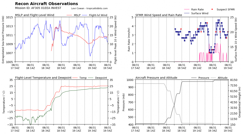
AF305 is en route to 90L and should reach the system around 3 PM EDT. Should have a better idea of what's going on at the surface. Recon is scheduled for 99L tomorrow if deemed necessary.
-
-
@ldub23 be out in the Atlantic MDR like...
-
 Category 3, 110 kts, Typhoon Maysak is approaching the islands of Kumejima, Japan, in the Okinawa prefecture. It might intensify a little more to become a Category 4 by landfall. James Reynolds is there documenting.
 -
Likewise visible also suggests 90L has a closed low level circulation. Just needs increased convection to get classified though recon could find winds sufficient for a TD sooner. This probably gets a name by tomorrow.
-
Visible suggests a better surface circulation than last night. Still needs better centralized convection to get a vort to ramp up however 99L is likely nearing classification. Perhaps by 5 pm?
-
-
Despite its fast motion, 99L appears to be organizing the past few hours. There is curved banding in the south and east envelope with convection. Near the center of the broad circulation, convective pulsing is percolating. This should help tighten a vorticity maximum and TD15 should get classifed soon thereafter by this evening. I think this does develop and makes landfall as a named storm. It is hauling through. If it can develop by this evening, it will have a shot at hurricane intensity prior to landfall, otherwise it may run out of time.
-
Seriously, if something significant does advance west out if the MDR, that has ECONUS landfall written all over it.


