

Windspeed
-
Posts
4,611 -
Joined
-
Last visited
Content Type
Profiles
Blogs
Forums
American Weather
Media Demo
Store
Gallery
Everything posted by Windspeed
-
Ensembles and operationals into the mid-range are hinting at an outbreak in the MDR. Two to three long-tracking hurricanes, especially given any left-behind stalls would increase seasonal ACE substantially regardless of any land threats. We'll definitely have to watch for anything that might remain shallow and develop near 60°W with the amplified NW ridge could capture and drive a potential system into the Antilles, Bahamas or ECONUS. And as[mention=9730]WxWatcher007[/mention] allluded to, could be a surprise in the GOM and potential threat with an amplified pattern in place.
-
000 WTNT41 KNHC 030252 TCDAT1 Hurricane Nana Discussion Number 8 NWS National Hurricane Center Miami FL AL162020 1000 PM CDT Wed Sep 02 2020 After the center of Nana nearly became exposed during the late afternoon, a new burst of convection developed near and to the south of the center which has resulted in strengthening this evening. Very recently received data from an Air Force Reserve reconnaissance aircraft has indicated that Nana has become a hurricane. The plane has measured a peak 700-mb flight-level wind of 72 kt to the north of the center, and peak SFMR winds of 62 kt earlier this evening. These data support an initial intensity of 65 kt, making Nana the fifth hurricane of the 2020 Atlantic basin hurricane season. Since Nana should make landfall along the coast of Belize within the next several hours, little additional strengthening is expected before the center crosses the coast. Rapid weakening will occur after landfall, and the new 12 through 36 hour intensity forecast reflects this. The low-level center is likely to dissipate over mountainous terrain within 48 hours, if not sooner. Nana is moving just south of due west at about 265/14 kt. A low- to mid-level ridge to the north of Nana should keep it moving on a west-southwestward motion during the next day or so. The guidance enveloped has shifted slightly southward and the new NHC track forecast has been adjusted accordingly. KEY MESSAGES: 1. Hurricane conditions and a dangerous storm surge will spread onshore along portions of the coast of Belize within the Hurricane Warning area through early Thursday. 2. Tropical storm conditions are expected in the tropical storm warning areas in Belize, the Bay Islands, Guatemala, and the Yucatan Peninsula of Mexico through early Thursday. 3. Heavy rainfall with isolated maximum amounts as high as 8 to 12 inches could result in flash flooding in Belize, Guatemala, and portions of southeastern Mexico and the Yucatan Peninsula. FORECAST POSITIONS AND MAX WINDS INIT 03/0300Z 17.0N 87.5W 65 KT 75 MPH 12H 03/1200Z 16.8N 89.2W 50 KT 60 MPH...INLAND 24H 04/0000Z 16.4N 91.6W 30 KT 35 MPH...INLAND 36H 04/1200Z 16.0N 93.9W 20 KT 25 MPH...POST-TROP/REMNT LOW 48H 05/0000Z...DISSIPATED $$ Forecaster Brown
-
 Ugh... https://www.theguardian.com/world/2020/sep/03/typhoon-maysak-ship-with-43-crew-and-nearly-6000-cattle-missing-off-japan
 -
lol... No, that would be unwise since they are legitimate tropical climatologists. Hugging operational model outputs isn't how long-range forecasting works. It isn't particularly great for debating long-range on a tropical message board either. But I digress...
-
In a nutshell, mid-range modeling has sucked this year for upper pattern features. Look at this GFS shear forecast when 99L (pre-Nana) was developing in the eastern Caribbean and tell me what you see and do not see? Edit: Might help if I post the right image. At any rate, it's probably unwise to bank on smaller upper anticyclonic features versus larger regional upper ridging. You can easily get burned when a small upper trough or pinched PV is underdone. Clearly the northerly shear was underdone in this case when trying to figure out potential setup three days in advance for 99L versus just having an overall larger / regional upper 200 hPa ridge. Even those don't always go perfectly. See: Laura with strong backflow upper convergence on the TC as it moved south of the Cuban shoreline. The following image is from 12z Sunday.
-
Last recon showed northerly shear had encroached and broken down Nana's core. New strong convection is going up over the center, but it will have to rebuild a new core against the ongoing shear for intensification to occur. The shear is forecast to drop this afternoon and the system still does have time to stack prior to landfall, but it would need to pull of some impressive restructuring to be anything stronger than a minimal hurricane at landfall.
-
Actually, EXTP pressure was 998.7 so there has been some strengthening. Let's see what the next pass shows.
-
Yeah, only flight level winds. Which if anything doesn't show much in the way of intensification from earlier.
-
That should have been km not nm. But yeah.. I don't necessarily disagree. It has an intact core though. Shear will lessen as time goes on. If anything, the vorticity maximum may be larger than what recon found earlier. The sheared CBs may be stretching the vortex and expanding it some.
-
CAPPI is not the best radar at 240km though. It's missing shallow core convection at that distance. That cyan ring looks concerning even if the SW eyewall has the big CBs right now that are being easterly sheared. At any rate, we'll have recon soon.
-
000 WTNT41 KNHC 012055 TCDAT1 Tropical Storm Nana Discussion Number 3 NWS National Hurricane Center Miami FL AL162020 500 PM EDT Tue Sep 01 2020 Although convection has waned somewhat since the previous advisory due to mid-level dry air entrainment, Nana still has enough deep convection over and surrounding the low-level center to keep the intensity at 45 kt. Upper-level outflow has continued to improve, with the associated anticyclone becoming more symmetrical. Another reconnaissance mission is scheduled for this evening. The initial motion estimate is 275/16 kt. There are no significant changes to the previous track forecast or reasoning. A pronounced deep-layer to the north of Nana is forecast to remain intact and even build westward over the next few days, keeping Nana moving in a general westward direction for the next 36 hours or so. Thereafter, the aforementioned ridge is expected to build west-southwestward across southern Mexico, driving the cyclone west-southwestward as well across northern Central America. The new NHC forecast track is similar to the previous advisory track, and lies close to a blend of the simple consensus models TVCN and GFEX, and the corrected- consensus models NOAA-HCCA and FSSE. The current northeasterly 15 kt of vertical wind shear and dry air intrusions should inhibit development for next 24 hours or so. However, the GFS and ECMWF models both forecast the shear to gradually decrease during the next 48 hours, becoming near 5 kt by 36 hours. The lower vertical shear, coupled with the already impressive outflow pattern, sea-surface temperatures of 29.5-30.5 deg C, and a moistening mid-level environment should allow for gradual strengthening for the next 24 hours, followed by more significant intensification thereafter, which will continue right up until landfall occurs. The NHC official intensity forecast is a blend of the simple consensus intensity model IVCN, and the corrected-consensus models NOAA-HCCA and FSSE. A Tropical Storm Warning and Tropical Storm Watch have been issued for the southern portion of the Yucatan Peninsula and the Caribbean Sea coast of Guatemala, respectively. KEY MESSAGES: 1. Tropical Storm Nana is now forecast to be a hurricane as it approaches the coast, and interests in Honduras, Guatemala, Belize, and Yucatan should closely monitor the progress of this storm. Strong winds, dangerous storm surge and very heavy rainfall causing flash flooding are becoming more likely from Nana. FORECAST POSITIONS AND MAX WINDS INIT 01/2100Z 16.8N 79.3W 45 KT 50 MPH 12H 02/0600Z 17.1N 81.5W 50 KT 60 MPH 24H 02/1800Z 17.3N 84.7W 55 KT 65 MPH 36H 03/0600Z 17.2N 87.3W 65 KT 75 MPH 48H 03/1800Z 16.9N 89.4W 45 KT 50 MPH...INLAND 60H 04/0600Z 16.5N 91.7W 20 KT 25 MPH...POST-TROP/REMNT LOW 72H 04/1800Z...DISSIPATED $$ Forecaster Stewart
-
lol... We got Omar. 000 WTNT45 KNHC 012048 TCDAT5 Tropical Storm Omar Discussion Number 5 NWS National Hurricane Center Miami FL AL152020 500 PM EDT Tue Sep 01 2020 Satellite images show that the system remains sheared with a bursting pattern on satellite, occasionally exposing the center, and a large area of curved bands in the southeastern quadrant of the circulation. Almost all of the subjective and objective Dvorak estimates, along with SATCON values, are between 35 to 40 kt, and the lower number is chosen as the initial wind speed since scatterometer data suggests 30 to 35 kt. This makes Omar the 15th named storm of the 2020 Atlantic hurricane season, and is the earliest 15th storm on record, besting the previous mark by about a week from Ophelia of 2005. Any chance for strengthening should end by tomorrow afternoon due to greatly increasing shear, and weakening is likely to commence by then. The persistence of the shear should cause the cyclone to decay into a remnant low in about 48 hours, if not sooner. No significant changes were made to the previous forecast, which is near the model consensus. The initial motion remains east-northeast or 065/13 kt. The cyclone is being steered by the northern side of the subtropical ridge, which is forecast to cause a similar motion through tomorrow and an eastward turn late week due to the orientation of the ridge. The only notable change to the forecast is a slow down at long range in most of the guidance, probably due to a shallow system no longer feeling the stronger deep-layer winds, so the NHC track prediction follows suit. The remnant low should dissipate in 4-5 days. FORECAST POSITIONS AND MAX WINDS INIT 01/2100Z 35.3N 71.5W 35 KT 40 MPH 12H 02/0600Z 36.1N 69.4W 35 KT 40 MPH 24H 02/1800Z 36.7N 66.7W 35 KT 40 MPH 36H 03/0600Z 37.2N 63.9W 30 KT 35 MPH 48H 03/1800Z 37.2N 61.1W 25 KT 30 MPH...POST-TROP/REMNT LOW 60H 04/0600Z 37.0N 59.2W 25 KT 30 MPH...POST-TROP/REMNT LOW 72H 04/1800Z 37.0N 57.4W 25 KT 30 MPH...POST-TROP/REMNT LOW 96H 05/1800Z 39.5N 53.0W 25 KT 30 MPH...POST-TROP/REMNT LOW 120H 06/1800Z...DISSIPATED $$ Forecaster Blake
-
Ruh roh, Raggy...
-
Big CB going up near the center.
-
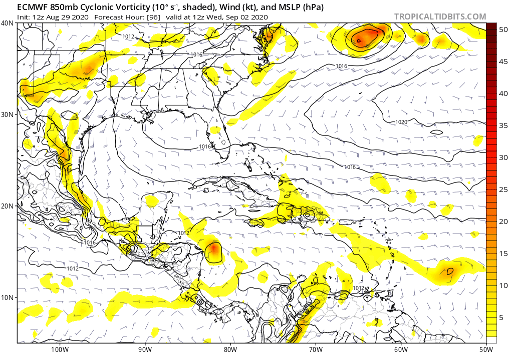
A system just north of the Antilles with that amplified ridge coming down looks fun.
-
AF308 will be taking off momentarily and should reach Nana in by 1630z. Should have new data for the 5PM update. Will be interesting to see how that tiny vortex is holding up against moderate easterly shear.
-
Something is bound to develop out of the extending WAM on steroids by the end of the week. Might get a long-tracker to slip by the TUTT before it amplifies. Way too early to know how that plays out.
-
Oh finally Mr. Euro decides to show...
-
Based on the last VDM and forward motion, the low-level vortex should be right under that symbol in this image. There is stronger convection going up just on the NW side. But it definitely needs to wrap to get more of a CDO look.
-
Thanks! And my apologies for questioning the validity, I just saw that the mission was over and could only pull the old one upon refresh. https://www.nhc.noaa.gov/text/MIAREPNT2.shtml
-
I thought AF307 was finished with their mission? You sure that isn't an old VDM?
-
lol.. 6nm. This reminds me of Iris back in 2001.
-
Yeah this thing likely ends up Hurricane Nana before landfall. Already well-defined core with 60 kt flight level winds and 50 kt SFMR.


