

Windspeed
-
Posts
4,738 -
Joined
-
Last visited
Content Type
Profiles
Blogs
Forums
American Weather
Media Demo
Store
Gallery
Everything posted by Windspeed
-
Southern around to northeastern semicircle of the eyeband is going bananas on GLM flash count over the past 20 minutes. Great time for one more pass.
-
RE:@Superstorm93 The second image here shows some intense mesos embedded in Delta's tiny eyewall.
-
It was classified a 40 MPH tropical storm at 8 AM EDT yesterday. It's been in rapid intensification / deepening ever since.
-
113 kt not far above the surface on that last dropsonde in the southern semicircle. This is probably a major by 11 AM EDT.
-
Just as an FYI, a statute mile is 1.15 nm. So 5 miles to nm is 5.75 and just rounding to 6nm. That being said, small eyewalls will fluctuate based on micro perturbations of strong meso bursts. That can morph and fluctuate the eyeband a nm or two even when small over short periods of time. Larger eyes do the same but it's obviously less noticeable due to larger diameter and area. Next recon could hypothetically find an even smaller eyewall on next mission, however, it has been reported open in portions of the band. It wouldn't surprise me if it expands a little as deep convection keeps bursting. Again, these small eyewalls are chaotic and futile to predict.
-
You can plainly see the small 6-8nm eye is merely obscured by high cirrus. That should clear out as the day progresses. This is a very small eyewall though. It's a little tough to forecast internal structural changes with such a tiny eye. An intense convective burst could even widen the eyeband and the eye could get larger without a traditional ERC. We've seen eyes get larger without an ERC. But 24 hrs is a long time when you have a rapidly intensifying core. MW doesn't reveal strong enough concentric banding for a new much larger eyewall to yet form. So really, Delta could very well make a run at Cat 5 prior to a NE Yucatán impact. It should still be a compact hurricane and core regardless of eyeband fluctuations.
-
Referring to TCG, not intensity, with respect to the globals. Underdone intensity with regards to initial intensity guidance. But that's no big deal. The big deal is failure by the ECMWF repeatedly this year to resolve TCG until it's already occurring.
-
Delta was classified a tropical depression at 11 PM EDT last night and upgraded to a 40 MPH tropical storm at 8 AM EDT this morning. That we are at hurricane intensity in less than 24 hours with a closed eyewall is pretty ominous. It's quite possible that Delta was already a TS prior to TD classification last night, regardless, this is signifantly fast cyclogenesis [emoji3591] hurricane. It looks like Delta is likely going to shame the initial intensity guidance from the past few days as well. Also, it's one thing for the ECMWF to missed TCG (yet again) on a system that remains weak or even low-end hurricane. But this is really just very poor global modeling right now seeing as how we're about to watch a intense major hurricane unfold in a climatologically favored region and timescale. Not even any of its ensembles had a major. #2020things
-
Cozumel had a 15.4 foot surge during Wilma and an 18.6 foot surge was recorded along the NE Yucatán coast during Gilbert for comparison. They can get a high surge in that region with a large hurricane.
-
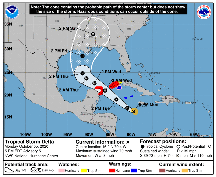
Brown typed a novel. Forecasting a major hurricane now. Track also shifted west towards NE Yucatán. 000 WTNT41 KNHC 052055 TCDAT1 Tropical Storm Delta Discussion Number 5 NWS National Hurricane Center Miami FL AL262020 500 PM EDT Mon Oct 05 2020 Visible satellite imagery shows that the convective banding of Delta has continued to quickly improve since this morning. The primary convective band now wraps entirely around the center, with what appears to be a banding-type eye feature occasionally noted. There are some dry slots between the convective bands but those appear to be gradually filling in. A NOAA Hurricane Hunter aircraft currently collecting data in the storm environment found peak SFMR winds of 55 kt during its first pass through the center from northwest to southeast. The plane also reported a minimum pressure of 983 mb, much lower than previously estimated. The aircraft also observed an 18 nmi-wide-eye that was open to the west-northwest. Assuming that there are stronger winds yet to be sampled in the northeastern quadrant, the initial intensity has been raised to 60 kt. Delta is situated within a very conducive environment for strengthening. The storm will be moving over SSTs of 29-30 degrees Celsius and the vertical wind shear is forecast to remain 5 kt or less while Delta traverses the northwestern Caribbean. These conditions are expected to allow for rapid strengthening over the next 24 to 36 hours. The SHIPS Rapid Intensification Index gives a better than 50 percent chance of a 35-40 kt increase in wind speed over the next 24 hours. The NHC intensity forecast follow suit by calling for rapid intensification over the next day or so, and Delta is forecast to be a major hurricane when is passes near or over the northeastern portion of the Yucatan peninsula. Once the storm reaches the central Gulf of Mexico in 60-72 hours, increasing southwestern vertical wind shear and cooler shelf waters over the northern Gulf are likely to result in some reduction in wind speed as the system nears the northern Gulf coast. Although there is still significant uncertainty regarding Delta's intensity when it nears the northern Gulf coast, it is becoming increasing likely that the system will pose a significant wind and storm surge threat to a portion of that area. The center has jogged southward again this afternoon, which appears to be primarily due to the system organizing rather than a true storm motion. The initial motion estimate remains an uncertain 275/7 kt. Delta should begin moving west-northwestward this evening, and a west-northwestward to northwestward motion around the southwestern portion of a deep-layer ridge to its northeast is expected over the next couple of days. The more southward initial position and more ridging over the eastern Gulf of Mexico has resulted in a significant westward shift in the track envelope through the first 60-72 hours. The NHC has been adjusted in that direction, and this has required the issuance of a Hurricane Warning for the northeastern portion of the Yucatan peninsula of Mexico. After 72 hours, a mid- to upper-level trough is forecast to develop over Texas which should cause Delta to turn northward and then north-northeastward toward the northern Gulf Coast. Although the track forecast has not changed much during the latter portion of the period, there is more cross-track spread in the model guidance than before, which has increased the uncertainty regarding potential landfall and the timing of Delta's approach to the northern Gulf Coast. Key Messages: 1. Dangerous storm surge and hurricane conditions are expected within portions of the northern Yucatan Peninsula of Mexico and are possible in extreme western Cuba beginning Tuesday night, and a Hurricane Warning is in effect. 2. Heavy rainfall will affect portions of Jamaica, the Cayman Islands, western Cuba and the northern Yucatan Peninsula during the next few days. This rainfall could lead to significant flash flooding and mudslides. 3. Tropical storm conditions are expected in portions of the Cayman Islands beginning tonight or early Tuesday, and a Tropical Storm Warning is in effect. 4. Delta is forecast to approach the northern Gulf Coast late this week as a hurricane. While there is large uncertainty in the track and intensity forecasts, there is an increasing risk of dangerous storm surge, wind, and rainfall hazards along the coast from Louisiana to the western Florida Panhandle beginning Thursday night or Friday. Residents in these areas should ensure they have their hurricane plan in place and monitor updates to the forecast of Delta. FORECAST POSITIONS AND MAX WINDS INIT 05/2100Z 16.2N 79.4W 60 KT 70 MPH 12H 06/0600Z 17.1N 80.9W 75 KT 85 MPH 24H 06/1800Z 19.0N 83.5W 95 KT 110 MPH 36H 07/0600Z 21.0N 86.2W 105 KT 120 MPH 48H 07/1800Z 22.6N 88.7W 105 KT 120 MPH 60H 08/0600Z 23.7N 90.6W 105 KT 120 MPH 72H 08/1800Z 24.8N 91.5W 95 KT 110 MPH 96H 09/1800Z 28.5N 91.5W 85 KT 100 MPH 120H 10/1800Z 33.0N 89.0W 40 KT 45 MPH...INLAND $$ Forecaster Brown
-
Recon is heading N now but I am uncertain if they're actually finished with the mission or are going to try for another pass. Edit: Well they've dropped back down to operational altitude so I guess they figured out the issue and are resuming reconnaissance.
-
But we have Space Force to fund!
-
VDM.
-
Damn... NOAA3 is having issues. They're circling but have reported they are finished with the mission. No NE-SW pass.
-
Gamma recon previously scheduled for tonight is canceled and that flight is diverted to Delta.
-
Recon just made a wonky 360° loop and circled. Hope they aren't having issues.
-
There's a cold pool of water just north of Cancun year-round mostly do to micro-climate trades there. It only extends north 50-100 miles. That and some land interaction would halt intensification. It might regain major intensity in the central GOM for a time. Again, this is hypothetical IF it crossed the NE Yucatán. But really the best chance for Cat 4/5 is going to be if Delta undergoes RI through Wednesday prior to traversing land or in the channel.
-
This could be a Cozumel/Cancun strike, yes. And a powerful one at that. I am aggressive on initial maximum intensity by the Yucatán Channel regardless if it strikes the NE Yucatán or skirts through.
-
Damn...
-
Recon going to get there right when a strong convective burst is going up. Should be at operational altitude in about 30 minutes.
-
Oh that's really a bad track for post-Laura recovery. Long way to go though.
-
Oh, hello ECMWF. So kind of you to join us.
-
The 12z GFS has backed off on stronger shear over the N. GOM. That doesn't mean it won't come back on the next run. That being said, there is a possibility that an intense Delta might not be rapidly weakening due to shear versus just leveling off and slowly weakening upon landfall. The SSTs around 26-26.5°C several hundered miles south of the coast will definitely halt intensification or start a weakening trend, but if Delta is hauling ass northward and at Cat 3 to 4 intensity, there is a chance it could still be a major at landfall if the weakening trend starts off slowly.
-
11 AM EDT discussion. I do think they're underdoing maximum intensity. After recon data is returned this afternoon, I'd imagine they'll bump up the forecasted intensity to a Category 3 on the 5 PM. We'll just have to wait and see how organized the vortex is per recon. ZCZC MIATCDAT1 ALL TTAA00 KNHC DDHHMM Tropical Storm Delta Discussion Number 4 NWS National Hurricane Center Miami FL AL262020 1100 AM EDT Mon Oct 05 2020 The convective structure of Delta has continued to improve this morning. Earlier microwave data and early-light visible satellite imagery showed that the center of the tropical cyclone re-formed farther south within the area of deep convection. Since that time, banding has continued to increase around the southern and eastern portion of the circulation, and a small CDO-like feature has formed. The intensity has been set at 40 kt, which is a blend of the subjective Dvorak estimate from TAFB and objective satellite intensity estimates from UW/CIMSS. A NOAA Hurricane Hunter aircraft is scheduled to investigate the tropical storm this afternoon, which should provide a better assessment of the cyclone's intensity, structure, and wind field. With the earlier center re-formation, the initial motion estimate is a somewhat uncertain 280/6 kt. Delta is expected to resume a west-northwestward motion later today. A northwestward heading around the southwestern portion of a deep-layer ridge should begin tonight or Tuesday, and that general motion with some increase in forward speed is expected to continue through 60-72 hours. After that time, a broad mid- to upper-level trough is forecast to develop over the south-central United States, which should weaken the western portion of the ridge and cause Delta to turn northward toward the northern Gulf Coast. After day 4, Delta should begin to accelerate north-northeastward or northeastward ahead of the aforementioned trough. The new NHC track forecast has been adjusted to the south and west of the previous advisory during the first couple of days, primarily due to the recent center re-formation and more southward initial position. After that time, the NHC track is not much different than the previous forecast and lies near the center of the tightly clustered dynamical model envelope. Delta is forecast to traverse very warm waters over the northwestern Caribbean Sea and be in a very low vertical wind shear environment during the next couple of days. These conditions should allow for significant strengthening during that time, and the NHC intensity forecast is at or above the various intensity aids. It is somewhat surprising that the intensity aids were generally a little lower this cycle, but the expected low shear and SHIPS rapid intensification index support the higher than climatological rate of intensification. After 72 hours, increasing southwesterly shear and the cooler shelf waters over the northern Gulf are likely to induce some weakening later in the period. The updated NHC intensity forecast calls for a faster rate of intensification over the next 48-60 hours, but is similar to the previous advisory thereafter. Key Messages: 1. Tropical storm conditions are expected in the Cayman Islands beginning late today or tonight, and a Tropical Storm Warning is in effect. 2. Dangerous storm surge and hurricane conditions are expected in portions of western Cuba by Tuesday afternoon, and a Hurricane Warning is in effect. 3. Heavy rainfall will affect portions of Jamaica, the Cayman Islands, and western Cuba during the next few days. This rainfall could lead to significant flash flooding and mudslides. 4. Delta is forecast to approach the northern Gulf Coast late this week as a hurricane. While there is large uncertainty in the track and intensity forecasts at these time ranges, there is an increasing risk of dangerous storm surge, wind, and rainfall hazards along the coast from Louisiana to the western Florida Panhandle. Residents in these areas should monitor the progress of Delta and check for updates to the forecast during the week. FORECAST POSITIONS AND MAX WINDS INIT 05/1500Z 16.4N 78.6W 40 KT 45 MPH 12H 06/0000Z 17.1N 79.6W 50 KT 60 MPH 24H 06/1200Z 18.7N 81.7W 60 KT 70 MPH 36H 07/0000Z 20.8N 84.3W 75 KT 85 MPH 48H 07/1200Z 22.8N 86.8W 85 KT 100 MPH 60H 08/0000Z 24.6N 89.1W 90 KT 105 MPH 72H 08/1200Z 26.0N 90.7W 90 KT 105 MPH 96H 09/1200Z 28.8N 91.1W 85 KT 100 MPH 120H 10/1200Z 33.1N 88.2W 40 KT 45 MPH...INLAND $$ Forecaster Brown NNNN
-
There is virtually no upper tropospheric influence from Gamma now as it is devoid of convection reaching mid-to-upper levels. Therefore, the more dominate upper ridge axis is likely to take over upper wind flow. Delta should be in a low shear environment as it traverses the NW Caribbean towards the channel. Additionally Delta's own intense convection is squashing what remains of the small PV feature. I think the TC models were overdoing Gamma's influence or there is convective feedback issues with what they are modeling as a TC north of the Yucatan when in reality it is just a low level wind / steering feature now with no influence on mid to upper heights.


