-
Posts
4,734 -
Joined
-
Last visited
Content Type
Profiles
Blogs
Forums
American Weather
Media Demo
Store
Gallery
Everything posted by Windspeed
-

2022 Atlantic Hurricane season
Windspeed replied to StormchaserChuck!'s topic in Tropical Headquarters
Well we need the AEW to spawn a surface low before I get too excited, but obviously if we do see genesis out of this, the modeled potential is worth the superlatives. It appears the Atlantic got tired of the whining and woke up. If this and a few other systems pan out, we should push ahead of normal climatological ACE into an active season. But unless the Caribbean goes bonkers in October, I am pretty confident we won't eek out a hyperactive season at this point. Here a nice tweet describing the setup for the potential future TC into the Caribbean. -
I thought there would be some lag time post exit of landmass for reintensification. Perhaps atleast 6-10 hours of ocean time. I mean this was a trek over the DR, even if the core remained over the lowlands. But I was considering the mountainous terrain impeding some of its low-level inflow into the core. Uhhh... that appears to be a big negatory, slappy. Fiona looks like it is about to experience some explosive deepening.
-
When modeling consensus and ensembles miss the mark, it just is what it is. Goes to show that tropical surface lows are still sometimes tough to nail even in the shorterm.
-
Ongoing onslaught of the back feeder bands continue. Daytime heating and instability may unfortunately increase low-level convective feed/fetch, so this sadly looks to continue throughout the day until Fiona can gain some distance. No way to paint the situation but dire at this point.
-
Agreed. I think most had expected a more northerly component to the WNW motion by this point. It's still drifting west of guidance, if subtle, having implications to shorterm intensification tonight when it clears the DR landmass. Low level inflow will be hindered more if it cannot gain some latitude. So a gradual decline intensity until it is east of Turks and Caicos seems logical now.
-
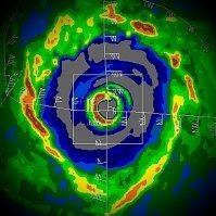
This is a good distance away from the NOAA radar tower in PR, so the returns from the beam are weak, but you can still easily make out the eye. Punta Cana was very likely near or in the northern eyewall this morning. They're now in the back/behind the right-front quadrant as Fiona is moving away. Fiona's structure is pretty amazing right now considering the core is entirely over land. Though this part of DR is lowlands and the outer circulation is still getting feed off the Carribean. Impressive, still.
-
If not for the close proximity of mountainous terrain and land interaction in general, Fiona would be closing in on major hurricane intensity tonight. This is no longer the appearance of a struggling hurricane. Outflow is excellent. Towers firing in the eyewall. It likely will not do anything too crazy since it will crossing over NE DR, but it certainly looks like Fiona will eventually become an intense hurricane near to or just east of the Turks and Caicos tomorrow. Perhaps a bit of recovery time depending on how long it takes to clear DR. But the atmospheric envelope looks primed.
-
That beast trough is so strong it may very well capture and phase Fiona into New Foundland, perhaps even Nova Scotia. Good take is that though Fiona may get intense, it may miss Bermuda cleanly to the west.
-
Most recent radar derived estimate...
-
Josh may have a little nasty encounter with the eyewall if he stays put as the core may take on a more WNW/NW vector soon as the vortex is clearly getting stacked and should feel the deep layer motion. Really this jog should be temporary given structure.
-
The eyewall looked to be reorganizing the past few hours on radar prior to the hiatus in update about 30 minutes ago. No surprise that the CDO is taking off again with a notable hot tower in progress on satellite. Likely due to intense convection wrapping around the northern semicircle of the vortex. It appears Fiona is strengthening again.
-
More or less drifting S of W but this may just be a temporary stall. Unfortunately the slow movement is still a nightmare situation with an intense band still crossing right over the heart of PR. Not a small band either. Just insane echoes continue over the island, on and on....
-
Looks like the inner core has weakened somewhat, likely due to land interaction and some disruption from the terrain, as the eye has filled in partially. Makes little difference as these training bands remain the biggest impact.
-
Looks like TJUA/NOAA's WSR-88D has gone down. Was really hoping it would stay online to estimate these absurd totals, which have already topped 15+ near the tower. Edit: Came back online. Latest images...
-
Unfortunately the slow and steady angle of approach is pretty much a worst case scenario from a flooding perspective. The core has only clipped the higher terrain, it is not weakening. But it's driving the southerly feed of moisture off the Carribean right over the island, with orographic enhancement. Maria was horrible and I don't want to say Fiona will eclipse that in impacts. But it may outperform even Georges from a flooding event. This is looking really bad.
-

2022 Atlantic hurricane season whining/banter
Windspeed replied to GaWx's topic in Tropical Headquarters
We don't have a CONUS major hurricane so season canceled. [emoji849] -
Are you saying done deal as in no US hit? PR is the US. Your angle there sounds like you were focusing on the CONUS. At any rate, Fiona is crawling and the worst of the hurricane (heavy precip) is going to drag prolonged over the heart of the island. Those folks are hurricane hardened, but flash flooding is always worrisome to life and infrastructure. Could see some nasty totals and a mudslide threat.
-
I mean even now the mid level canopy/circulation is already tilted to the E/ENE of the low level vorticity maximum. A strong persistent convective envelope has allowed TCG to occur way in advance of modeling, hence now the TD. But it's going to be a prolonged struggle. It has certainly surprised already, but the same environment may keep it at best a weak TS until it reaches the northern Antilles.
-
Shear may also impart track adjustments if the upper level vector is southwesterly. I'd stay it's not a horribly confident track position for the DR/Haiti at this stage. I'd be more inclined to see some slight poleward adjustments if the LLC gets tugged north of west downstream. Of course that relies on there being persistent deep convection. Long way to go. May be over the DR or might get tugged slightly north of the GAs. Patience will be a virtue watching this track verify.
-
Not expecting anything in the short-to-midrange. Really just need to survive as a disturbance and get better dynamics after the wave breaking event. There may be some pretty good dynamics to enhance whatever 96L is / wave near the GA or just north of it. This means a lot of boring watching until next week. I think this could be a player if it's positioned well at that time. Specifically this setup. Any tropical surface low under that is going to intensify: This is borderline long range however. So really how and when those upper dynamics set up is a huge ?. ECMWF is actually faster at kicking out the TUTT. So all we can do is watch how modeling evolves and if there is a disturbance in the vicinity, if that would be 96L or something behind it.


