

Windspeed
-
Posts
4,461 -
Joined
-
Last visited
Content Type
Profiles
Blogs
Forums
American Weather
Media Demo
Store
Gallery
Posts posted by Windspeed
-
-
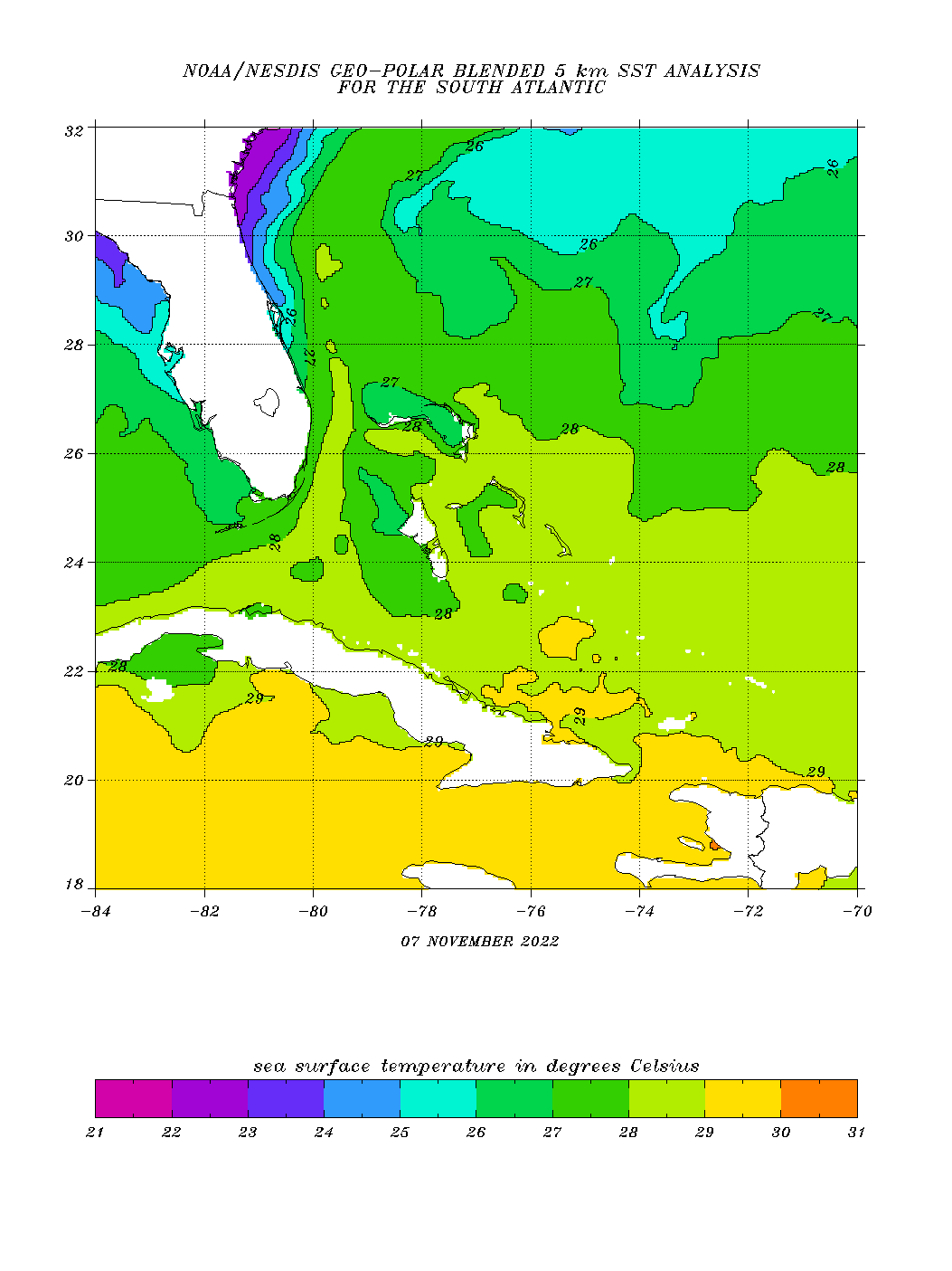
Good for discussion, but I think dry air entrainment was a bigger factor yesterday through this morning. Upper tropospheric temperatures are cooler therefore 26-27°C OHC can be quite sufficent for evaporate induced strong lapse rates to drive convection. We've seen strong late hurricanes in the middle of the Atlantic Basin over relatively moderate SSTs, even around the 26°C threshold as that threshold can drop several degrees based on upper environmental conditions. In other words, if Nicole can mix out the dry air, I do not think the moderate SSTs will be as big a deterrent for strengthening this evening. The Bahama landmasses are also not very big with respect to being a deterrent for strengthening as well. Perhaps for already intense hurricanes or stalled ones there, yes. But not one with a fairly decent relative forward motion. I do think Nicole will become a hurricane tonight despite the small interactions with land and the moderate SSTs if the core can be successful at mixing out the southerly fetch of a dry airmass. We shall see.There was a relatively cool eddy Nicole passed over yesterday evening - 26-27c isotherm. My thinking is this was a big contributor to rapid warming of the convection. And that’s been validated by the big changes today while atmospheric conditions are largely the same.
-
 2
2
-
-
Nice little reminder about cold pool aloft and tropopause cloud top temperatures. Convection is never going to look as impressive as a hurricane at the same latitude from June into October. Cloudtops simply don't reach those heights or get as cold as previous months from a tropical surface low. Doesn't mean you can't get a strong hurricane as long as core convection is organized.
-
4
-
-
A region of favorable divergence and low shear aloft will be available to this system if the core placement cooperates. The GFS may look overdone on intensity, but there is an actual scenario that this could be a decent hurricane. Again, the track has to unfold and position with a region of cold pool aloft and low shear. The SSTs are plenty warm enough to sustain intensification even as a major hurricane, though obviously that is a low probability as the core may be inland over the peninsula before it could max out. A purely tropical strong TS to Cat 1 hurricane is certainly looking more and more likely versus a hybrid system now however. The system should at least have some length of time for it to organize as such prior to interaction with land.
-
1
-
-
Pretty decent improvement over the past few hours. Eye is starting to clear out on visible. Running out of time though.

-
Upgraded to Hurricane Lisa per 7AM CDT advisory package. Still plenty of time for this to keep intensifying prior to landfall. A category 2 seems possible.
-
Martin has formed a clear and distinct eye. Deep convection aided by cold pool upper tropospheric temperature forcing over the past few days has allowed 25°C SSTs to remain sufficiently warm enough to fuel high lapse rates. We should have a rare November day with two simultaneous hurricanes in the Atlantic Basin.

-
1
-
-
Meh, negligible at best. Merely background noise.Slight change in the HWRF from last run
-
1
-
 1
1
-
-
A good example of why satellite can sometimes be deceiving. Roslyn is still an intense hurricane. Despite the eye being overcast with cloud debris, the eyewall is still very much intact and should have destructive impacts through landfall. Note the extreme lightning GLM data. Structure is still solid.
-
That's nearly a pattern flip. Notice the WAR appear out if nowhere versus previous runs. New Foundland low gone. May be a flook or something to watch for upcoming runs.Huge shift west this last one after an east trend
-
Yes. There may also be an outer band consolidating into an outer eyewall, but it apparently is not organized enough to prevent Rosslyn's small eyewall from continued rapid intensification. Most likely a Cat 4, perhaps upper Cat 4 at the moment with an impressive satellite presentation. Inevitably there will be weakening prior to landfall either due to structural changes or increasing shear but at least for the moment, Rosslyn is a beast.
Perfect cat 4 micro cane based on current satellite
.
-
Long range 12z GFS op is up to some Caribbean shenanigans...
-
1
-
-
-
Yeah I busted on this one big time though clearly the potential was there, the thing just took forever and a day to get the low-level structure aligned with the prolonged intense mid-level vortex / convective pulses. A lot of this was probably due to the duration of land interaction with Venezuela as the broad low was organizing. But fortunately for Nicaragua, the RMW did not tighten until just prior to landfall. Additionally, though globals were slow to intensify and suggested intensification only just prior to landfall, I lack much enthusiasm that it was due to detailed modeling of the low-level structure and land interaction, and they would have failed to show RI beyond if or if not structural issues persisted. Again, the ingredients were there, sometimes loose structure of a broad low-level envelope with multiple vorticy maximums gets in the way.
-
4
-
-
-
Seems to be the case. Shear is just being too much of a deterrent for allowing Julia to resolve surface structural issues. Gonna bust hard on this one it seems. Would need RI to be occurring now. Starting to look unlikely.Northerly Wind Shear is limiting Julia from being stronger, likely a good thing for Central America barring any unexpected organization. -
Still expecting Julia to rapidly intensify today. Despite its initial structural issues at the surface, I do not think it will take long for intensity to ramp up quickly once the eyewall is established. There are hints of this on radar. Again, sure, time is limited over water, but it may have just enough time to peak at a high intensity prior to any first ERC. I think Julia landfalls as a major and depending on how rapidly, even a Cat 4 is still possible once rapid intensification is underway. I think we tend to be conservative and for good measure, as intensity forecasting remains difficult. But ventilation is certainly good enough to get the job done despite 10 kts of shear. I'm going to call 105-110 kts into the Nicaraguan coastline in the early AM hours of Sunday.

-
2
-
-
Recon is funky. It's as if the LLC is repositioning again.
-
Boy how things can rapidly change. Unfortunately, Julia is going to be an intense hurricane before it reaches Nicaragua. Two major changes: 1) Recon has found that the LLC has relocated under the very dense/deep -80°C formative CDO. 2) The mid-level circulation is now stacking with a slight tilt, but shear has abated significantly in the past 9 hours. With these developments and the quickly organizing core, I fully expect Julia to become a major hurricane, and perhaps even peaking at Category 4 prior to landfall. Too much time left over 29-30°C SSTs and fast enough motion to get the most out of available OHC.

-
2
-
-
Missfired into the seasonal thread. Shear vector is pivoting easterly. New strong convection should now wrap the LLC. At any rate, BOOOM!!!

-
1
-
-
Nice thread...
-
Agree with Andy here that bands holding position north of the exposed center indicates shear is dropping fast, perhaps to around 10 kts. So the exposed center may be temporary as a remnant region of suppression where higher shear values earlier blew off/broke down mid level vorticity. Likely slow restructuring today and then as soon as a core is built this evening, more significant intensification should ensue.
-
1
-
-
Hilarious, no sooner than I posted that impressive hot tower above that did look like an eye band (core) forming... *splOOOOpF* The entire column collapses due to some northerly mid level shear. So this is likely to be a gradual process unless a core can establish sooner than later.

-
1
-
-
Per 12z ATCF Best Track, this is now TS Julia, pending NHC following suite at the 11AM package.
-
1
-
-
This should be Julia on the next advisory package. Very intense hot tower going up right adjacent to the center that looks to be a formative eastern eyeband. You can make the outline based on GLM lightning data, which is pretty neat. This thing is about to go off.

-
2
-
Hurricane Nicole
in Tropical Headquarters
Posted
Best radar presentation yet. More symmetrical eyewall, though not fully closed ATM. The W to SW semicircle however is looking better organized and currently raking Grand Bahama, which should be ongoing for a while this afternoon with current motion.